
Côté Gold Mine Project
Environmental Assessment Report
Document Reference Number: 27

April 2016
Cover photo credited to IAMGOLD Corporation.
© Her Majesty the Queen in Right of Canada, represented by the Minister of Environment and Climate Change, (2016).
Catalogue No: En106-150/2016E-PDF
ISBN : 978-0-660-04947-2
This publication, with the exception of the cover photo and all figures, may be reproduced in whole or in part for non-commercial purposes, and in any format, without charge or further permission. Unless otherwise specified, you may not reproduce materials, in whole or in part, for the purpose of commercial redistribution without prior written permission from the Canadian Environmental Assessment Agency, Ottawa, Ontario K1A 0H3 or info@ceaa-acee.gc.ca. The copyrights for the cover photo and all figures are owned by IAMGOLD Corporation. You may not reproduce the cover photo and figures, for non-commercial or commercial purposes, without prior written permission from IAMGOLD Corporation.
This document has been issued in French under the title: Projet de mine d'or Côté - Rapport d'évaluation environnementale
Executive Summary
IAMGOLD Corporation (the proponent) is proposing the construction, operation, decommissioning, and abandonment of the Côté Gold Mine Project (the Project), which includes an open pit gold mine, an on-site metal mill and four structures for diverting water, located 20 kilometres southwest of the community of Gogama in northeastern Ontario.
The mine and metal mill would have an ore production capacity and an ore input capacity, respectively, of 60 000 tonnes per day, with a life of approximately 15 years. The four water course realignment structures would have the capacity to divert 14 271 500, 15 695 800, 17 994 500, and 13 286 000 cubic metres of water per year.
The Canadian Environmental Assessment Agency (the Agency) conducted an environmental assessment of the Project in accordance with the Canadian Environmental Assessment Act, 2012 (CEAA 2012). The Project is subject to CEAA 2012 because it involves activities described in the schedule to the Regulations Designating Physical Activities as follows:
- item 6: the construction, operation, decommissioning and abandonment of a new structure for the diversion of 10 000 000 cubic metres per year of water from a natural water body into another natural water body;
- item 16 (b) : the construction, operation, decommissioning and abandonment of a new metal mill with an ore input capacity of 4000 tonnes per day or more; and
- item 16 (c) : the construction, operation, decommissioning and abandonment of a new rare earth element mine or gold mine, other than a placer mine, with an ore production capacity of 600 tonnes per day or more.
The proponent entered into a voluntary agreement with the Ontario Ministry of the Environment and Climate Change to subject its project to the requirements of Ontario's Environmental Assessment Act. The Agency and the Province of Ontario conducted the federal environmental assessment and Ministry Review of the proponent's individual environmental assessment cooperatively to the fullest extent possible.
This environmental assessment report (the Report) summarizes the assessment conducted by the Agency, including the information and analysis on the potential environmental effects of the Project considered, and the Agency's conclusions on whether the Project is likely to cause significant adverse environmental effects, after taking into account the implementation of mitigation measures. The Agency prepared the Report with expert advice from federal authorities —Environment and Climate Change Canada, Fisheries and Oceans Canada, Natural Resources Canada, Transport Canada and Health Canada—and provincial ministries—the Ontario Ministry of the Environment and Climate Change, the Ontario Ministry of Northern Development and Mines, the Ontario Ministry of Natural Resources and Forestry, and the Ontario Ministry of Tourism, Culture and Sport. Furthermore, the Report was informed by comments submitted throughout the environmental assessment process by Aboriginal groups and the public.
The Agency analyzed environmental effects on areas of federal jurisdiction in relation to section 5 of CEAA 2012, including: fish and fish habitat; migratory birds; current use of lands and resources for traditional purposes by Aboriginal peoples; health and socio-economic conditions of Aboriginal peoples; physical and cultural heritage; and any structure, site or thing that is of historical, archaeological, paleontological or architectural significance for Aboriginal peoples. The Agency also assessed effects related to changes to the environment that are directly linked or necessarily incidental to federal decisions that may be required for the Project by Environment and Climate Change Canada, Fisheries and Oceans Canada, Transport Canada and Natural Resources Canada. The assessment also considered transboundary effects, in relation to direct greenhouse gas emissions.
The Report outlines several potential or established Aboriginal or treaty rights held by First Nations and Métis that could be potentially affected by the Project, including hunting, trapping, fishing, plant harvesting, navigation by traditional travel routes, and the use of sites and areas of cultural importance for the exercise of rights.
The main potential adverse environmental effects from the Project in relation to section 5 of CEAA 2012 are:
- effects on fish and fish habitat from loss and alteration of habitat, changes to water levels and flows, and potential surface water contamination;
- effects on migratory birds and species at risk due to vegetation clearing, habitat loss and fragmentation, sensory disturbances (i.e. artificial light, sound and human presence) and vehicle collisions;
- effects on the health of Aboriginal peoples due to fugitive dust and airborne contaminants;
- effects on traditional land use for hunting, trapping, fishing, plant harvesting, and navigation by traditional travel routes;
- effects on Aboriginal physical and cultural heritage, and structures and sites of historical and archaeological importance; and
- effects, that are directly linked or necessarily incidental to federal decisions, on other ecological components of the environment (e.g. wetlands and species reliant on riparian habitat) and socio-economic conditions (e.g. canoeing, licensed bear hunting, trapping and bait harvesting).
Mitigation measures will be implemented to prevent or reduce potential adverse effects of the Project. The Agency has identified mitigation measures and follow-up program requirements for consideration by the Minister of Environment and Climate Change in establishing conditions as part of the Decision Statement under CEAA 2012. Conditions accepted by the Minister of Environment and Climate Change would become legally binding on the proponent if the Minister ultimately issues a Decision Statement indicating that the Project may proceed.
The Agency, in selecting key mitigation and follow-up measures, was informed by the proponent's commitments, expert advice from federal authorities and provincial ministries, and comments from Aboriginal groups and the public. Key mitigation measures include implementing an offsetting plan for serious harm to fish, managing effluent and surface water quality including by limiting seepage from the tailings management facility, avoiding vegetation clearing during migratory bird core nesting periods, minimizing emissions of fugitive dust and airborne contaminants, minimizing effects of environmental changes caused by the Project on traditional land and resource uses, providing access to land to the extent that it is safe and protective of health, protecting archaeological artifacts, and avoiding disturbances to active eagles' nests.
The Report outlines comments received from Aboriginal groups related to environmental effects. The effects identified include increased pressure on resources and the potential for reduced access to hunting, trapping, fishing, plant harvesting, and cultural areas of importance. Aboriginal groups also commented on changes to water quality and quantity, potential contamination of fish and other wildlife resources along with the associated health impacts. Aboriginal groups expressed concern that the proponent's construction timeline is not set and there is the potential for Aboriginal peoples' use of the area to change before the Project proceeds.
The Agency endeavoured to select key mitigation and follow-up measures to address effects on Aboriginal peoples which would also serve as accommodation of potential impacts on potential or established Aboriginal or treaty rights. In relation to the uncertainty regarding the timing of project commencement, the Agency recommends, for inclusion in the Minister's Decision Statement, a condition that would require the proponent to ensure that its actions in meeting the conditions set out in the Minister's Decision Statement are informed by the best available information, including Aboriginal traditional knowledge. This would include proponent consultation with Aboriginal groups throughout project implementation and public reporting on how it considered the best available information in its actions. To further address potential impacts on current uses and existing or potential rights, the Agency also recommends, for inclusion in the Minister's Decision Statement, that the proponent be required to develop and implement a traditional land and resource use follow-up program, in consultation with Aboriginal groups. These conditions combined will enable Aboriginal groups to have opportunities to provide up-to-date information about their use of the area on a continuous basis throughout all phases of the Project, to inform the proponent's actions in meeting the other conditions. The Agency is of the view that the Project's potential impacts on potential or established Aboriginal or treaty rights have been adequately identified and appropriately mitigated or accommodated for the purpose of decision-making under CEAA 2012.
Public comments received were largely focused on impacts to fish and aquatic life. The Agency has identified key mitigation measures that address adverse effects on fish and fish habitat.
The Agency concludes that the Project is not likely to cause significant adverse environmental effects, taking into account the implementation of key mitigation measures.
Table of Contents
- Executive Summary
- Table of Contents
- List of Tables
- List of Figures
- List of Abbreviations and Acronyms
- Glossary
- 1 Introduction
- 2 Project Overview
- 3 Consultation Activities and Advice Received
- 4 Purpose of the Project and Alternatives Considered
- 5 Geographical Setting
- 6 Predicted Changes to the Environment
- 7 Predicted Effects on Valued Components
- 7.1 Fish and Fish Habitat
- 7.2 Migratory Birds
- 7.3 Aboriginal Peoples – Current Use of Lands and Resources for Traditional Purposes
- 7.4 Aboriginal Peoples – Health and Socio-Economic Conditions
- 7.5 Aboriginal Peoples – Physical or Cultural Heritage, and Effects on Historical, Archaeological, Paleontological or Architectural Sites or Structures
- 7.6 Other Effects Related to Federal Decisions
- 8 Other Effects Considered
- 9 Impacts on Potential or Established Aboriginal or Treaty Rights
- 9.1 Potential or Established Aboriginal or Treaty Rights in the Project Area
- 9.2 Potential Adverse Impacts of the Project on Potential or Established Aboriginal or Treaty Rights
- 9.3 Proposed Accommodation Measures
- 9.4 Issues to be Addressed During the Regulatory Approval
- 9.5 Issues Outside the Scope of the Environmental Assessment Process
- 9.6 Agency Conclusion Regarding Impacts to Aboriginal or Treaty Rights
- 10 Conclusions and Recommendations of the Agency
- 11 Appendices
- Appendix A: Environmental Effects Rating Criteria
- Appendix B: Summary of Environmental Effects Assessment
- Appendix C: Proposed Watershed Changes
- Appendix D: Proposed Water Management Systems
- Appendix E: Summary of Aboriginal Consultations
- Appendix F: Mitigation measures, monitoring and follow-up proposed by the proponent
- Appendix G: List of Key Mitigation Measures, Monitoring and Follow-Up Considered by the Agency
- Appendix H: Changes to Water Bodies for Which a Federal Decision may be pursued by the Proponent
- Appendix I: Summary of Comments on the Draft Environmental Assessment Report
List of Tables
- Table 1-1: Valued components selected by the Agency
- Table 1-2: Decisions pursuant to other federal legislation that may be required before the Project can proceed
- Table 1-3: Local and regional study areas
- Table 2-1: Project activities
- Table 6-1: Selected substances with maximum concentrations above water quality guidelines within the initial effluent mixing zone in the lower basin of Neville Lake
- Table 6-2: Habitat types and estimated habitat loss for the mine site as it relates to the available habitat in the associated terrestrial biology study areas
- Table 7-1: Riparian stream and lake habitat loss and gain, prior to application of offsetting plan
- Table 7-2: Potential sources of contaminants on water quality and its predicted effect on fish
- Table 7-3: Predicted loss of suitable migratory bird habitat caused by the Project
- Table 8-1: Predicted species at risk suitable habitat loss
- Table 8-2: Potential physical changes from accidents and malfunctions
- Table 8-3: Potential effects on valued components from accidents and malfunctions
- Table 8-4: Unique prevention, mitigation, monitoring, follow-up and emergency response measures proposed for selected accidents and malfunctions
- Table A-1: Definitions and limits used to assign levels of effect for each rating criterion
- Table A-2: Definitions and limits used to assign the magnitude of an effect for each effect assessment indicator
- Table A-3: Proponent's decision tree for determining overall significance of a residual effect
- Table C-1: Proposed watercourse realignments
- Table C-2: Proposed retention dams
- Table F-1: Environmental change mitigation measures, monitoring and follow-up activities
- Table F-2: Valued component mitigation measures, monitoring and follow-up activities
- Table F-3: Accidents and malfunctions mitigation measures, monitoring and follow-up activities
List of Figures
- Figure 1-1: Aquatic biology local and regional study areas
- Figure 1-2: Terrestrial biology local and regional study areas
- Figure 2-1: Project location
- Figure 2-2: Project components
- Figure 5-1: Local watersheds and existing water flow directions
- Figure 7-1: Overview of traditional knowledge and traditional land use study regional and local aquatic study areas preliminary site plan footprint
- Figure 7-2: Overview of traditional knowledge and traditional land use study regional and local terrestrial study areas preliminary site plan footprint
- Figure C-1: Existing local watershed boundaries and flow directions within the Mollie River and Mesomikenda Lake subwatersheds
- Figure C-2: Anticipated local watershed boundaries and flow directions within the Mollie River and Mesomikenda Lake subwatersheds, including retention dams and watercourse realignments that will be in place from the end of construction until the open pit is filled at the end of stage 1 of the abandonment phase
- Figure C-3: Anticipated local watershed boundaries and flow directions within the Mollie River and Mesomikenda Lake subwatersheds, including retention dams and watercourse realignments that will be in place at the end of stage 2 of the abandonment phase.
List of Abbreviations and Acronyms
- CEAA 2012
- Canadian Environmental Assessment Act, 2012
- ha
- hectare
- km
- kilometre
- m
- metre
- m³/y
- cubic metres per year
- the Agency
- Canadian Environmental Assessment Agency
- the Project
- Côté Gold Mine Project
- the proponent
- IAMGOLD Corporation
- the Report
- Environmental Assessment Report
- the Minister
- Minister of Environment and Climate Change
Glossary
- A-weighted
- The frequency weighting that correlates measured sound pressure levels to the response of the human ear to noise.
- Abandonment phase
- The phase of the Project that occurs after decommissioning activities have been completed. This phase is divided into two stages: stage 1 will last until the open pit is filled with water; stage 2 will be the final stage of rehabilitation that will commence after the open pit is filled. Referred to as the post-closure phase in the proponent's Environmental Impact Statement.
- Acid rock drainage
- Some rocks, typically those containing an abundance of sulfide minerals, when exposed to water and air can release water which is more acidic than the natural surrounding environment. Often associated with metal leaching.
- Construction phase
- The phase of the Project during which physical activities are undertaken in connection with vegetation clearing, site preparation, and building or installation of any component of the Project, prior to operations.
- Contact water
- Water which has come into contact with mine site components and their associated infrastructure.
- Cyanidation
- A technique for extracting gold from low-grade ore, using a chemical reaction that involves a solution of cyanide.
- Decommissioning phase
- The phase of the Project after commercial production has permanently ceased, during which project infrastructure related to operations is removed and rehabilitation of the mine site begins. Referred to as the closure phase in the proponent's Environmental Impact Statement.
- Effluent
- An effluent – hydrometallurgical facility effluent, milling facility effluent, mine water effluent, tailings impoundment area effluent, treatment pond effluent, seepage and surface drainage, treatment facility effluent other than effluent from a sewage treatment facility – that contains a deleterious substance (as defined in subsection 1(1) of the Metal Mining Effluent Regulations).
- Environmental Impact Statement
- The document prepared by the proponent that identifies and assesses the environmental effects of the Project, and the measures proposed to mitigate those effects, in accordance with the Environmental Impact Statement Guidelines provided by the Agency.
- Environmental Impact Statement Guidelines
- A document prepared by the Agency that identifies the requirements for the preparation of the Environmental Impact Statement. This document specifies the nature, scope and extent of the information required from the proponent for the Project.
- Leaching
- A chemical process for the extraction of valuable minerals from ore. Also, a natural process by which groundwater dissolves minerals, thus leaving the rock with a smaller proportion of some minerals than it contained originally.
- Lentic
- Water bodies or features that contain still waters, such as ditches, ponds, marshes and lakes.
- Littoral
- The near shore areas of water bodies.
- Local study area(s)
- A study area boundary that corresponds to the area(s) where most effects as a result of the Project are expected to occur. The proponent defined a local study area for each environmental discipline. Refer also to "regional study area".
- Lotic
- Water bodies or features that contain flowing waters, such as channels, creeks, streams and rivers.
- Metal leaching
- The release of metals from rocks exposed to water and air, which can increase the concentrations of these metals in contact water. Often associated with acid rock drainage.
- Mine rock
- Rock which does not contain any minerals in sufficient concentration to be considered ore, but which must be removed in the mining process to provide access to the ore.
- Mine site
- The geographic area overprinted by mining-related project components (e.g. open pit, tailings management facility, mine rock area, ore stockpiles, polishing pond, processing plant). Refer also to "property boundary" and "project footprint".
- Mine Waste
- The waste products generated from mining activities, which includes overburden, mine rock, low grade ore, and tailings.
- Operation phase
- The phase of the Project during which commercial production takes place.
- Overburden
- Material overlying the ore deposit, including rock as well as soil and other unconsolidated (loose) materials.
- Particulate matter (PM10)
- Particles with diameters of 10 micrometres or less.
- Fine particulate matter (PM2.5)
- Particles with diameters of 2.5 micrometres or less.
- Property boundary
- The extent of lands for which the proponent will control surface access. Refer also to "mine site" and "project footprint".
- Project footprint
- The geographic area overprinted by mining-related project components at the mine site, and the transmission line alignment. Refer also to "mine site" and "property boundary".
- Process water
- Water that is added to the crushed ore during extraction of gold at the ore processing plant.
- Regional study area(s)
- A study area boundary that takes into account baseline conditions across an area that extends beyond the local study area to capture all potential effects and to support effects predictions at a regional scale. The proponent defined a regional study area for each environmental discipline. Refer also to "local study area".
- Riparian
- The areas of lands adjacent to streams, rivers, lakes and wetlands, where the vegetation and soils are strongly influenced by the presence of water.
- Self-sustaining/self-sustainability
- The degree to which ecosystems, populations or communities can support themselves without external assistance.
- Tailings
- The mixture of ore material, water, and residual chemicals left over after gold is removed from ore in the ore processing plant. Solid material in tailings is usually the size of sand grains or smaller.
- Transmission line alignment
- Refers to the transmission line and corridor.
- Valued component
- Biophysical or human features of the environment that have importance due to their roles in the ecosystem and the worth people place on them.
1 Introduction
1.1 Purpose of the Environmental Assessment Report
IAMGOLD Corporation (the proponent) is proposing the construction, operation, decommissioning, and abandonment of the Côté Gold Mine (the Project), which includes an open pit gold mine, an on-site metal mill and four structures for diverting water, located 20 kilometres (km) southwest of the community of Gogama in northeastern Ontario.
The mine and mill would have an ore production capacity and an ore input capacity, respectively, of 60 000 tonnes per day, with a life of approximately 15 years. The four water course realignment structures would have the capacity to divert 14 271 500, 15 695 800, 17 994 500 and 13 286 000 cubic metres of water per year (m³/y).
The purpose of the Environmental Assessment Report (the Report) is to summarize the assessment conducted by the Canadian Environmental Assessment Agency (the Agency), including the information and analysis considered, and the Agency's conclusions on whether the Project is likely to cause significant adverse environmental effects, after taking into account the implementation of mitigation measures.The Agency will provide the Report to the Minister of Environment and Climate Change for consideration in reaching her CEAA 2012 decisions on the significance of any adverse environmental effects of the Project and in establishing conditions for inclusion in the Decision Statement.
1.2 Scope of Environmental Assessment
1.2.1 Environmental assessment requirements
The Project is subject to the Canadian Environmental Assessment Act, 2012 (CEAA 2012) because it involves activities described in the schedule to the Regulations Designating Physical Activities. Specifically, the Project includes the construction, operation, decommissioning and abandonment of a new gold mine, metal mill, and four new structures to divert water from a natural water body into another natural water body. These meet the descriptions and thresholds set out in 6, 16(b) and 16(c) of the schedule to the Regulations Designating Physical Activities.
Based on the project description submitted by the proponent on March 15, 2013, the Agency initiated a screening of the Project to determine if an environmental assessment was required. On March 26, 2013, the Agency invited the public and Aboriginal groups to provide comments on the Project and its potential environmental effects. On May 10, 2013, the Agency determined that an environmental assessment of the Project was required and the environmental assessment was officially initiated on May 13, 2013. On July 9, 2013, the Agency issued the Environmental Impact Statement Guidelines to identify the nature, scope and extent of information required from the proponent.
Cooperative environmental assessment requirements
The proponent entered into a voluntary agreement with the Ontario Ministry of the Environment and Climate Change to subject its project to the requirements of Ontario's Environmental Assessment Act, and undertook a provincial individual environmental assessment. The proponent conducted environmental studies and sought input from Aboriginal groups and the public to address both federal and provincial requirements. The Agency and the Province of Ontario conducted the federal environmental assessment and Ministry Review of the proponent's individual environmental assessment cooperatively to the fullest extent possible. This included working closely on the technical review and sharing key information.
In consideration of section 5 and subsection 19(1) of CEAA 2012, the following factors were considered in the environmental assessment:
- the environmental effects of the Project, including environmental effects of malfunctions or accidents that may occur in connection with the Project and any cumulative environmental effects that are likely to result from the Project in combination with other physical activities that have been or will be carried out;
- the significance of those effects;
- comments from the public;
- mitigation measures that are technically and economically feasible and that would mitigate any significant adverse environmental effects of the Project;
- the requirements of the follow-up program in respect of the Project;
- the purpose of the Project;
- alternative means of carrying out the Project that are technically and economically feasible and the environmental effects of any such alternative means;
- any change to the Project that may be caused by the environment;
- transboundary effects, including in relation to direct greenhouse gas emissions; and
- species listed under the Species at Risk Act that may be affected by the Project.
In addition to public comments, the Agency also considered comments from Aboriginal groups, including community knowledge and Aboriginal traditional knowledge pursuant to subsection 19(3) of CEAA 2012.
1.2.2 Selection of valued components
Valued components are biophysical or human features of the environment that have importance due to their roles in the ecosystem and the worth people place on them. The valued components selected by the Agency are presented in Table 1-1.
In accordance with subsection 5(1) of CEAA 2012, the environmental assessment considered the significance of the potential adverse environmental effects on environmental components that are within federal jurisdiction, including:
- effects on fish and fish habitat;
- effects on migratory birds;
- effects on Aboriginal peoples of any change that may be caused to the environment on the current use of lands and resources for traditional purposes, health and socio-economic conditions, physical and cultural heritage, or any structure, site or thing that is of historical, archaeological, paleontological or architectural significance.
Several federal decisions pursuant to other legislation may be required for the Project to proceed (Table 1-2). Therefore, in accordance with subsection 5(2) of CEAA 2012, the environmental assessment also considered:
- changes that may be caused to the environment that are directly linked or necessarily incidental to any federal decisions pursuant to other legislation; and
- effects of any changes that may be caused to the environment, referred above, on health and socio-economic conditions, physical and cultural heritage, or any structure, site or thing that is of historical, archaeological, paleontological or architectural significance.
| Valued Component | Rationale |
|---|---|
| Effects identified pursuant to subsection 5(1) of CEAA 2012 | |
| Fish and fish habitat | The loss and alteration of fish habitat and potential loss of fish associated with watercourse realignments, and the potential for disturbance to fish spawning from blasting of the open pit, impedance of fish passage from changes in water flow, and the potential of fish contamination or mortality from changes in water quality. |
| Migratory birds | The potential for incidental killing or harming of birds and eggs (e.g. from the action of clearing terrestrial vegetation and wetlands, and changes to water levels around ground-level nests), the loss and fragmentation of suitable habitat, new sensory disturbances (i.e. artificial light, sound and human presence), and increased vehicle collisions. |
| Current use of lands and resources for traditional purposes by Aboriginal peoples | Changes in the availability of, and access to, lands and resources for traditional plant harvesting, hunting, trapping, fishing, and changes to navigable canoe routes. |
| Health and socio-economic conditions of Aboriginal peoples | The potential for contamination of fish, drinking water and other country foods due to changes in water and air quality, exposure to air contaminants and noise, and changes to the availability of, and access to resources used for commercial purposes. |
| Physical and cultural heritage, and any structure, site or thing that is of historical, archaeological, paleontological or architectural significance for Aboriginal peoples | The potential for disturbance or loss of, and changes in access to, cultural heritage resources and sites of archaeological importance. |
| Effects identified pursuant to subsection 5(2) of CEAA 2012 | |
| Other ecological components of the environment and socio-economic conditions | The loss or alteration of water bodies associated with federal decisions may cause potential adverse environmental effects on:
|
| Potential Federal Decision | Project Component, Activity, or Effect |
|---|---|
| * The proponent indicated it intends to pursue the opt-in provision for Transport Canada's review and approval of works in navigable water, where applicable. | |
Fisheries Act
|
Serious harm to fish (including the death of fish or any permanent alteration to, or destruction of, fish habitat) |
Metal Mining Effluent Regulations under the Fisheries Act
|
Use of fish-frequented water bodies for mine waste disposal |
Navigation Protection Act
|
Construction or placement of a ‘work' in, on, over, under, through or across any non-scheduled navigable water for which the proponent requests that the Navigation Protection Act be made applicable |
Navigation Protection Act
|
Ability to dewater any navigable water (not just scheduled waters), or deposit into any navigable water or non-navigable water that flows into a navigable water |
Explosives Act
|
Facilities for the manufacture and storage of explosives |
In addressing federal and provincial environmental assessment requirements, the proponent identified potential effects across many environmental disciplines by analyzing the interactions of the various project components with the physical, biological and human environments. Specific effects assessment indicators (Appendix A) were selected to predict and report on potential changes to the environment as a whole (e.g. dust, noise, water quality, vegetation communities, migratory birds, navigable waters, heritage sites). The Agency reviewed the changes predicted for each of the assessment indicators selected by the proponent, and considered the significance of adverse environmental effects on the valued components outlined in Table 1-1.
The environmental assessment also considered the adverse effects of the Project on wildlife species listed in the Species at Risk Act, their critical habitat and species designated by the Committee on the Status of Endangered Wildlife in Canada.
1.2.3 Spatial and temporal boundaries
Spatial and temporal boundaries define the areas and timeframes within which the Project may interact with the environment and cause environmental effects. Several spatial boundaries are considered in the Report:
- Mine site. The geographic area overprinted by mining-related project components (i.e. open pit, tailings management facility, mine rock area, ore stockpiles, polishing pond, ore processing plant).
- Transmission line alignment. The transmission line and corridor.
- Project footprint. The geographic area overprinted by all project components, including the mine site and transmission line alignment.
- Property boundary. The area where the proponent would control surface access (predicted to extend beyond the mine site components).
- Local study areas. Areas studied for each environmental discipline, which correspond to where most effects are predicted to occur.
- Regional study areas. Areas studied for each environmental discipline, to capture all potential effects and take into account baseline conditions across a broader area to support the prediction of effects at a regional scale.
The local and regional study areas differed for each environmental discipline (Table 1-3). The aquatic and terrestrial biology study areas are illustrated in Figure 1-1 and Figure 1-2.
Temporal boundaries identify when an effect may occur in relation to specific project activities. Generally, these boundaries are based on a single project phase, or a combination of phases, to reflect the timing and duration of project activities that are likely to cause adverse environmental effects on valued components. Four project phases are considered in the Report:
- Construction. When physical activities are undertaken in connection with vegetation clearing, site preparation, and building or installing any component of the Project, prior to operations.
- Operation. When commercial production takes place.
- Decommissioning. After commercial production has permanently ceased, when project infrastructure related to operations is removed and rehabilitation of the mine site begins.
- Abandonment. After decommissioning activities have been completed, and divided into the period during which the open pit is filled with water (stage 1) and final rehabilitation activities after the open pit has filled (stage 2).
| Environmental Discipline | Local Study Area | Regional Study Area |
|---|---|---|
| Air Quality | Extends approximately 5 km from the main project emission sources (e.g. locations of proposed drilling, blasting, transportation, material handling). | Extends approximately 10 km from the main project emission sources. |
| Noise and Vibration | Extends approximately 5 km from the main project noise sources (e.g. locations of proposed blasting, use of heavy machinery, transportation), and 1 km on either side of the transmission line alignment. | Extends approximately 10 km from the main project noise sources and 1 km on either side of the transmission line alignment. |
| Hydrogeology | One general study area, encompassed by local watershed boundaries: the Great Lakes/James Bay Watershed divide along the south and southwest; Upper Mollie River Watershed to the west of the open pit; Mesomikenda Lake to the east; Somme River system associated with Neville Lake Watershed to the north and northwest. | |
| Hydrology, Climate, and Water Quality | Defined by lakes and watersheds in the vicinity and downstream of project infrastructure: Great Lakes/James Bay Watershed divide along the south; the Chester Lake and Bagsverd Lake inflow to the west; Mesomikenda Lake to the east; Somme River system associated with Neville Lake Watershed to the north and northwest. | Extends downstream of mine site to the confluence of the Mollie River and the Mesomikenda Lake outflow, to include the total watershed area upstream of the Minisinakwa Lake Dam monitoring point. |
| Aquatic Biology (Figure 1-1) |
Mine site and downstream water bodies receiving effluent or surface drainage, or that may be affected by watercourse realignments. | Extends downstream of mine site to the confluence of the Mollie River and the Mesomikenda Lake outflow, discharging into Minisinakwa Lake. |
| Terrestrial Biology (Figure 1-2) |
Extends 2 km around the mine site and to the southwest to include Chester Lake, and 1 km from the centerline of the transmission line alignment. | Extends 30 km from the boundary of the Local Study Area, and 2 km from the centerline of the transmission line alignment. |
| Land and Resource Use; Traditional Knowledge and Land Use | Coincident to terrestrial or aquatic biology local study areas. | Coincident to terrestrial or aquatic biology regional study areas. |
| Archaeology and Built Heritage | Extends 2 km around the mine site and 1 km on either side of transmission line alignment. | Extends 30 km around the mine site and 2 km on either side of transmission line alignment. |
| Socio-economics | Includes Gogama and Mattagami First Nation reserve (Mattagami Indian Reservation #71), and a portion of Highway 144 connecting communities to the Project. | Includes Gogama, city of Timmins, city of Greater Sudbury, Unorganized North Sudbury Subdivision and Unorganized Timiskaming West. Includes a portion of Highway 144 connecting the Project with the city of Timmins to the north and city of Greater Sudbury to the south. Also includes the Flying Post First Nation, the Mattagami First Nation, the Brunswick House First Nation, the Matachewan First Nation, and the Métis Nation of Ontario (Region 3). |
Figure 1-1: Aquatic biology local and regional study areas
Source: IAMGOLD Corporation, January 2016.
Figure 1-2: Terrestrial biology local and regional study areas
Source: IAMGOLD Corporation, January 2016.
1.2.4 Methods and approach
To complete its analysis of potential adverse effects on each valued component outlined in Table 1-1, the Agency reviewed various sources of information, including:
- the Environmental Impact Statement submitted by the proponent in May 2014, and amended in February 2015;
- additional information that the Agency requested from the proponent during the review of the Environmental Impact Statement;
- advice from expert federal departments and provincial ministries; and
- comments received from the public and Aboriginal participants.
The Agency assessed the significance of adverse effects on each valued component in accordance with the Agency's Operational Policy Statement: Determining Whether a Designated Project is Likely to Cause Significant Adverse Environmental Effects under CEAA 2012[1]. This included use of the following rating criteria, defined by the proponent for each assessment indicator, to evaluate the predicted levels of effect after mitigation:
- Magnitude is a qualitative or quantitative measure to describe the size or degree of the effect relative to the baseline conditions.
- Extent is the geographic area on, or through, which the effect will occur.
- Duration is the period of time over which the effect will occur.
- Frequency is the rate of occurrence of the effect, or how often it will occur within a given time period.
- Reversibility is the degree to which the effect can be reversed.
The definitions and limits used to assign the level of effect for each rating criterion are presented in Appendix A (Table A-1 and Table A-2). The Agency based its analysis on effects to valued components that are directly linked to changes in the environment.
The Agency assessed the significance of the residual effects on each valued component, taking into account the decision tree used by the proponent (Appendix A, Table A-3). The decision tree combined the level (low, moderate or high) assigned to each rating criterion for each effect. The significance of a residual effect is determined by taking into consideration the mitigation measures and key design features proposed by the proponent and all other measures that the Agency considered appropriate.
Appendix B summarizes the residual effects assessment for all valued components in relation to routine operations during all phases of the Project. The Agency's analysis and conclusions on the significance of adverse environmental effects are presented in Chapter 7.
2 Project Overview
2.1 Project Location
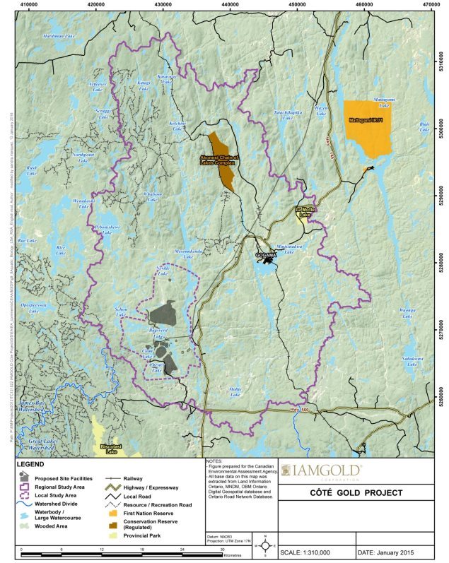
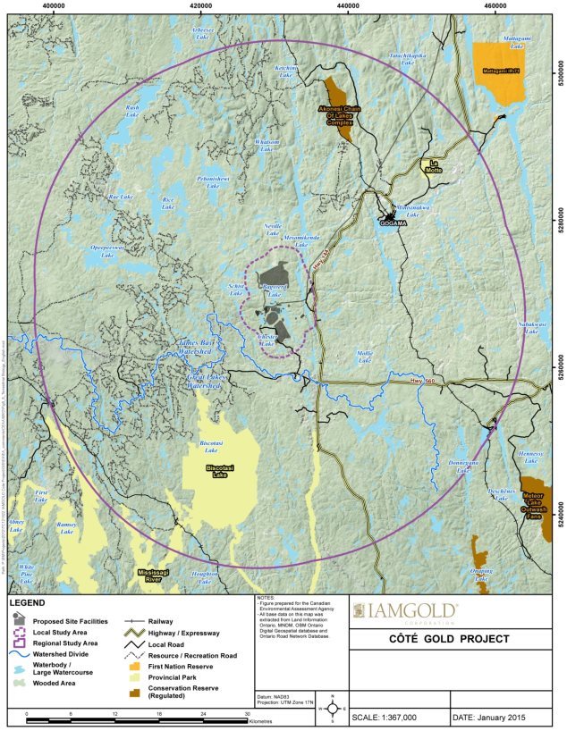
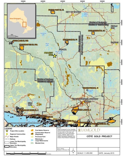
The Project is located in Chester and Neville Townships in the district of Sudbury, northeastern Ontario (Figure 2-1). It is approximately 20 km southwest of Gogama, 40 km south of the Mattagami 71 Reserve, 130 km southwest of Timmins, and 200 km northwest of Sudbury. The Project is also located within the Treaty 9 area of Ontario, known as the James Bay Treaty of 1905-1906, which covers almost two-thirds of northern Ontario.
Figure 2-1: Project location
Source: IAMGOLD Corporation, January 2016.
2.2 Project Components
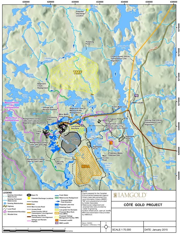
The Project as proposed includes the following components, as depicted in Figure 2-2:
- Open pit. The open pit would be approximately 210 hectares (ha) in surface area, and 550 metres (m) deep. Mining is proposed to occur at an ore production capacity of 60 000 tonnes per day over a 15-year period.
- Mine rock area. Approximately 850 million tonnes of mine rock would be stockpiled. Approximately 20 million tonnes of overburden would also be stored within the mine rock area. The mine rock area height is not predicted to exceed 150 m.
- Low-grade ore stockpile. A low-grade ore stockpile area would be designed to accommodate up to 17.5 million tonnes of low-grade ore. This stockpile would serve for future processing purposes. The proponent does not anticipate leftover stockpiled low-grade ore after the operation phase.
- Ore processing plant. Ore would be crushed, and gold would be recovered by gravity separation and cyanidation. Doré (gold) bars would be produced on-site for shipment offsite. Cyanide in process water would be destroyed in an on-site closed-loop process using sulphur dioxide and air.
- Tailings management facility. Approximately 261 million tonnes of tailings would be stored, in a storage area of approximately 840 ha. The maximum projected dam heights would be 40 to 45 m tall. A reclaim pond would be formed towards the central east end of the tailings management facility, with a minimum capacity of 2.9 million m³/y.
- Retention dams and watercourse realignments. Several retention dams and a total of 7.9 km of watercourses would be built to realign the Mollie River around the proposed open pit, and to realign Bagsverd Creek around the proposed tailings management facility. Four of these proposed watercourse realignments are considered structures used to divert water under CEAA 2012. Côté Lake would be drained. Further details on dams and watercourse realignments are given in Appendix C.
- Water management facilities. A mine water pond would be built near the ore processing plant to store mine water. A polishing pond would be built on the north end of the tailings management facility to store excess mine water from the mine site prior to discharge to the environment. Collection ponds and ditches would be built around the mine rock area, low-grade ore stockpile and tailings management facility. Freshwater would be taken via pipeline from Mesomikenda Lake. Further details on the on-site water management and recycling are given in Appendix D.
- Effluent discharge pipeline. A pipeline would extend from the polishing pond to the final effluent discharge point in Neville Lake, at the outflow of Bagsverd Creek.
- Transmission line alignment. The 230-kilovolt transmission line would consist of three segments, totaling a length of 120 km. The transmission line would connect to the existing Hydro One Network in Timmins at the Porcupine Substation. Approximately 14 km of access roads would be required at points along the transmission line.
- Road development. The existing Sultan Industrial Road, located south of Côté Lake, would be the dedicated main access point to the Project. Chester Access Road, an active forestry haul road managed by a third party and shared with the proponent, would be rerouted around the proposed mine rock area. On-site haul and service roads would be built to link the main Project facilities, further linking to existing access roads.
- Aggregate operations. Approximately 40 million tonnes of non-acid generating mine rock and overburden would be reused as construction materials for, among others, the tailings management facility dams, concrete manufacturing and road construction.
- Associate buildings, facilities and infrastructure. These would include a maintenance garage, a warehouse and administration complex, an accommodations complex, a fuel and lube bay, a sewage plant, areas set aside for construction materials and equipment, and facilities for the manufacturing and storage of explosives.
2.3 Project Activities and Schedule
Key activities associated with the construction, operation, decommissioning, and abandonment of the Project, and schedules anticipated by the proponent, are listed in Table 2-1. Changes to the watercourse realignments and the on-site water management system in each project phase are explained further in Appendix C and Appendix D.
Construction would be able to commence once the federal and provincial environmental assessment processes are complete and the proponent has been issued all applicable approvals and permits. However, the proponent has indicated the start of construction will be dependent on positive project economics and a stable outlook on the value of gold in the global marketplace. The operation phase is predicted to start approximately two years following the commencement of construction, and continue for 15 years. The decommissioning phase is predicted to last for approximately two years. The abandonment phase is predicted to occur in two stages: stage 1, the natural filling of the open pit with water, is anticipated to take between 50 and 80 years; stage 2 would occur after the open pit is filled.
Figure 2-2: Project components
Source: IAMGOLD Corporation, January, 2016
|
Construction Phase |
Operation Phase |
Decommissioning Phase |
Abandonment Phase |
|---|---|---|---|
|
† These activities are discussed in further detail in Appendix C ‡ These activities are discussed in further detail in Appendix D |
|||
|
|
|
Abandonment Stage 1: (50 to 80 years)
Abandonment Stage 2: (following Stage 1)
|
3 Consultation Activities and Advice Received
Public and Aboriginal participation in the environmental assessment provided feedback and information that was considered by the Agency in its analysis. Local and traditional knowledge about the project location was also considered in identifying potential environmental effects.
Advice received from federal authorities and key information shared between the Agency and the Province of Ontario further informed and supported the Agency's review of the Project. The Agency and the Province of Ontario conducted the federal environmental assessment and Ministry Review of the proponent's individual environmental assessment cooperatively to the fullest extent possible. This included participating in joint meetings with some Aboriginal groups and sharing key information received from public and Aboriginal participants throughout the concurrent processes.
3.1 Public Participation
3.1.1 Public participation led by the Agency
The Agency provided four opportunities for the public to participate in the environmental assessment process. The public was invited to comment on:
- whether an environmental assessment is required (March 26, 2013 to April 15, 2013),
- the draft Environmental Impact Statement Guidelines (May 13, 2013 to June 12, 2013),
- the proponent's Environmental Impact Statement (June 2, 2014 to July 2, 2014), and
- the draft Report and potential conditions (February 2, 2016 to March 3, 2016).
Notices of these opportunities to participate were posted on the Canadian Environmental Assessment Registry's Internet site, and individuals and groups who had expressed an interest during earlier phases were notified directly.
Groups participating in the public consultations included the Northwatch Coalition for Environmental Protection, the Mesomikenda Cottagers Association, other community and business organizations, and local residents.
The Agency supported public participation through its Participant Funding Program. Northwatch Coalition for Environmental Protection was allocated $10 406.65 from the program.
During the Environmental Impact Statement review period, the Agency also participated in public open houses with the proponent and representatives from federal authorities and provincial ministries. These public open houses were held in Timmins on June 23, 2014; Greater Sudbury on June 24, 2014; and Gogama on June 25, 2014. These sessions provided opportunities for members of the public to learn and provide comments about the environmental assessment process, the Project and the proponent's Environmental Impact Statement.
Key issues raised by the public during the environmental assessment include:
- changes to water quality and quantity, particularly in Mesomikenda Lake;
- effects on fish and fish habitat, aquatic species, wildlife, birds, species at risk, and vegetation, including terrestrial and aquatic habitat loss and compensation;
- changes to air quality, noise levels, light and visual aesthetics;
- potential for acid rock drainage and metal leaching;
- effects on human health;
- effects on navigation and land accessibility;
- cumulative effects;
- aspects of the mitigation measures and alternatives assessment; and
- proposed mine site management and closure plans.
Comments received from the public are summarized throughout Chapters 6, 7, 8 and the final appendix of this report. All comments received were considered in the finalization of the Report and in the conditions the Agency will recommend to the Minister of Environment and Climate Change in reaching her CEAA 2012 decisions.
3.1.2 Public participation activities organized by the proponent
The proponent engaged local residents from the community of Gogama, and the cities of Greater Sudbury and Timmins. In addition, the proponent consulted other potentially affected or interested stakeholders including local land users, business and community organizations, and government agencies.
Public consultation and engagement activities by the proponent included public notifications, holding numerous meetings, hosting 10 open houses, conducting site visits, maintaining a project website, and developing and issuing plain language materials (e.g. fact sheets and newsletters) to share information and receive feedback about the Project.
3.2 Aboriginal Consultation
3.2.1 Aboriginal consultation led by the Agency
The Government of Canada has a legal duty to consult and, where appropriate, accommodate Aboriginal peoples when the Crown contemplates conduct that might adversely impact potential or established Aboriginal or treaty rights. Aboriginal consultation is also undertaken more broadly as an important part of good governance, sound policy development, and appropriate decision-making. In addition to the federal government's broader obligations with regard to Aboriginal consultation, CEAA 2012 requires that all federal environmental assessments consider any project-related effects on health and socio-economic conditions, physical and cultural heritage, the current use of lands and resources for traditional purposes, and changes to any structure, site or thing that is of historical, archaeological, paleontological or architectural significance.
For the purposes of this environmental assessment, the Agency served as the Crown Consultation Coordinator to facilitate a whole-of-government approach to consultation.
The Agency identified the following Aboriginal groups for consultation based on the Agency's analysis of the potential for the Project to adversely impact potential or established Aboriginal or treaty rights:
- the Mattagami First Nation (represented by Wabun Tribal Council);
- the Flying Post First Nation (represented by Wabun Tribal Council);
- the Brunswick House First Nation;
- the Métis, represented by the Métis Nation of Ontario Region 3 Consultation Committee (the Métis Nation of Ontario);
- the Algonquin Anishinabeg Nation Tribal Council; and
- the Matachewan First Nation [2].
The Agency administers funding from its Participant Funding Program to support Aboriginal participation in the environmental assessment process. Funds were provided to reimburse eligible expenses of Aboriginal groups that participated in the environmental assessment. Four of the above identified Aboriginal groups applied for and received funding through this program (the Mattagami First Nation, the Flying Post First Nation, the Brunswick House First Nation and the Métis Nation of Ontario). In total, the Agency allocated $189 702.04 to support Aboriginal groups' participation in the environmental assessment.
In order to fulfill the Crown consultation obligations, the Agency conducted Aboriginal consultation in an integrated manner with the environmental assessment process. The Agency identified the Mattagami First Nation, the Flying Post First Nation, the Brunswick House First Nation and the Métis Nation of Ontario as groups that are most likely to experience impacts from the Project. The Agency provided opportunities throughout the environmental assessment for dialogue with these groups about their concerns through phone calls, correspondence, and in-person meetings. The Agency provided regular updates to the Aboriginal groups to keep them informed of key developments and to solicit feedback. In addition, the groups were invited to participate in the public consultation opportunities described in Subsection 3.1.1.
Three Aboriginal groups provided considerable comments in written correspondence and oral input at meetings throughout the environmental assessment: the Mattagami First Nation, the Flying Post First Nation, and the Métis Nation of Ontario. In June 2014, the Agency held community meetings and open houses with all three groups, including representatives from the Aboriginal groups, the Agency and the proponent. An additional meeting was held in July 2014 with the Wabun Tribal Council and representatives from the Mattagami First Nation, the Flying Post First Nation and their third-party consultants. These meetings provided an opportunity for members of Aboriginal groups to hear presentations and provide comments on the environmental assessment process and the proponent's Environmental Impact Statement documentation. Subsequent meetings occurred with the Métis Nation of Ontario in February 2015 and August 2015, and with the Wabun Tribal Council in June 2015, to discuss environmental assessment timelines and outstanding concerns. The Agency held in-person meetings with all three groups during the review period for the draft Report and potential conditions.
The Brunswick House First Nation was not able to meet with the Agency throughout most of the environmental assessment phases, but provided some written correspondence. The Agency directly and substantively engaged with the Brunswick House First Nation in an in-person meeting during the review period for the draft Report and potential conditions.
The Agency considered the Algonquin Anishinabeg Nation Tribal Council and the Matachewan First Nation to be less likely to experience impacts from the Project. These groups were notified of key steps in the environmental assessment process and invited to comment; however, no comments were received.
Key issues raised by Aboriginal groups during the environmental assessment include:
- changes to water quality and quantity;
- effects to fish and fish habitat, aquatic species, wildlife, birds, species at risk, and vegetation, including terrestrial and aquatic habitat loss and compensation;
- effects on Aboriginal peoples, including:
- health and socio-economic conditions,
- physical and cultural heritage and archaeological sites, and
- current use of lands and resources for traditional purposes;
- scope of the proponent's impact assessment related to the impacts described above;
- cumulative effects;
- potential for accidents and malfunctions;
- aspects of the baseline studies, methodology, mitigation measures, monitoring and alternatives assessment;
- site management and closure plans; and
- potential changes to baseline conditions in relation to potential delays in project timelines.
Potential effects on Aboriginal peoples are discussed further in Sections 7.3, 7.4, 7.5 and 9. Appendix E contains a summary of comments raised by the Aboriginal groups during the environmental assessment along with the proponent and Agency responses. Comments received during the review of the draft Report and potential conditions are summarized in the final appendix of this report. All comments received were considered in the finalization of the Report and in the conditions the Agency will recommend to the Minister of Environment and Climate Change in reaching her CEAA 2012 decisions.
3.2.2 Aboriginal consultation and engagement organized by the proponent
The proponent engaged all Aboriginal groups identified by the Agency to discuss issues by holding over 45 meetings, hosting eight open houses, conducting five site visits, having an on-site Aboriginal liaison, maintaining a project website, and developing and issuing plain language materials (e.g. fact sheets and newsletters) to share information and receive feedback.
The proponent provided financial support to the Mattagami First Nation, the Flying Post First Nation and the Métis Nation of Ontario to conduct traditional knowledge and traditional land use studies, and to review the Environmental Impact Statement and other environmental assessment documents where appropriate.
3.3 Participation of Federal and Other Experts
Pursuant to section 11 of CEAA 2012, federal authorities in possession of specialist or expert information or knowledge with respect to the Project provided advice in relation to determining whether an environmental assessment was required. Pursuant to section 20 of CEAA 2012, these federal authorities participated in the review of the Environmental Impact Statement Guidelines and the proponent's Environmental Impact Statement, and provided input into the preparation of the Report.
The following federal authorities have regulatory and statutory responsibilities in relation to the Project:
- Fisheries and Oceans Canada: Fisheries Act.
- Environment and Climate Change Canada: Canadian Environmental Protection Act, 1999; Migratory Birds Convention Act, 1994; Species at Risk Act; and the pollution prevention provisions of the Fisheries Act, including the Metal Mining Effluent Regulations.
- Natural Resources Canada: Explosives Act.
- Transport Canada: Navigation Protection Act.
The following federal authorities provided input on each phase of the environmental assessment process based on specialist or expert information or knowledge:
- Fisheries and Oceans Canada: related to fish and fish habitat that are part of, or support, a commercial, recreational or Aboriginal fishery and provisions related to fish passage and flow.
- Environment and Climate Change Canada: related to air quality, method and location of mine waste disposal, effluent discharges related to mine waste management, geochemistry, water quality and quantity, non-aquatic species at risk, migratory birds, meteorology, climate change, and accidents and malfunctions.
- Natural Resources Canada: related to geochemistry and management of mined materials, groundwater quantity and groundwater-surface water interactions.
- Transport Canada: related to navigation.
- Health Canada: related to potential impacts on Aboriginal health related to country food, water quality, noise and air quality.
The Agency and the Ontario Ministry of the Environment and Climate Change conducted the federal and provincial environmental assessment processes cooperatively to the fullest extent possible, which included working closely on the review of technical information, sharing key information received from public and Aboriginal participants, and participating in joint meetings with some Aboriginal groups. The following provincial ministries provided advice to the Agency: Ontario Ministry of the Environment and Climate Change; Ontario Ministry of Northern Development and Mines; Ontario Ministry of Natural Resources and Forestry; and Ontario Ministry of Tourism, Culture and Sport.
4 Purpose of the Project and Alternatives Considered
4.1 Purpose of the Project
The proponent is planning to construct, operate and eventually reclaim an open pit gold mine to produce gold for sale in the global marketplace. The environmental assessment is being undertaken in anticipation of favourable gold prices.
4.2 Alternative Means of Carrying Out the Project
CEAA 2012 requires that every environmental assessment of a designated project take into account the alternative means of carrying out the project that are technically and economically feasible, and consider the environmental effects of any such alternative means. The proponent identified alternatives for major project components, their environmental effects and the rationale for selecting the preferred option.
4.2.1 Alternatives assessment
Mining method
Two options were assessed for ore extraction: open pit and underground mining. Open pit mining was selected because the ore to be extracted is low-grade and widely distributed close to the surface; therefore, underground mining was not considered an economically and technically suitable option.
Open pit mining will result in more disturbances to the terrestrial environment. The proponent proposes to position the mine rock area close to the open pit and build higher stockpiles to minimize the project footprint. Open pit mining generates greater air and noise emissions than underground mining, and potentially greater effects on fish and aquatic habitats, including in this case the dewatering of Côté Lake. However, the proponent has proposed mitigation measures to minimize or prevent environmental effects.
Mine water management system
The proponent focused its assessment on an integrated mine water system, which involves recycling as much water as possible from the mine water pond, reclaim pond, polishing pond and various collection ponds for ore processing purposes. The alternative option of a separate mine water treatment without an integrated water recycling system was not assessed, as it would require taking substantially more freshwater from the natural environment throughout the implementation of the Project.
Mine rock and overburden management
The proponent selected permanent storage and disposal of mine rock and overburden, adjacent to the open pit, as the preferred option for general mine rock and overburden management. A portion of mine rock and overburden would be stockpiled elsewhere for construction or used for final site reclamation activities. The proponent acknowledged that backfilling the mine rock and overburden stockpiles into the open pit at decommissioning would have environmental advantages, but that it is costly for large, single open pits, and would render the Project uneconomical.
Three locations for mine rock and overburden storage were assessed, to the northeast, southeast, and south of the open pit. The proponent selected the location south of the open pit, as it would result in a more cost-effective operating plan due to lower haul distance and would reduce potential effects on Mesomikenda Lake and its neighbouring cottages.
Gold recovery
The proponent addressed various alternatives for gold recovery, including non-cyanide and cyanide recovery methods and combinations of the two. A combination of gravity recovery (non-cyanide) and cyanide leaching was selected to minimize cyanide use while maintaining an economically favourable gold recovery rate. The proponent has indicated that cyanide will be recycled and ultimately destroyed, prior to the discharge of process water from the ore processing plant to the tailings management facility.
Treatment of cyanide at process plant
The proponent assessed three options for treatment of cyanide at the ore processing plant: in-plant cyanide destruction using a sulphur dioxide and air treatment, natural cyanide degradation within the tailings management facility with supplemental hydrogen peroxide treatment, and natural cyanide degradation within the tailings management facility without supplemental hydrogen peroxide treatment. The proponent selected the in-plant sulphur dioxide and air treatment option, as it was found to be the most secure method with lowest environmental risk. The natural cyanide degradation options would increase the risk of cyanide entering the natural environment by seepage from the tailings management facility, wildlife toxicity due to wildlife accessing the tailings management facility, and downstream effects in the event of dam failure or unintended release.
Tailings management
The proponent identified three methods for tailings management deposition: tailings slurry (consisting of 50 percent solid material), thickened tailings (consisting of 60 percent solid material), and paste-thickened tailings (consisting of 68 percent solid material). Tailings slurry was selected because the thickening of tailings, along with the transport of thickened or paste-thickened tailings was considered to be too costly for the quantity of tailings that would be produced by the mine.
Six alternatives for the location of the tailings management facility were assessed, located between 4.5 and 11 km north of the ore processing plant. The preferred location was the closest to the ore processing plant (4.5 km away), thus requiring the shortest pipeline lengths. This alternative also had a good bedrock foundation and a moderate natural bowl feature, thus requiring fewer and lower tailings dams. It also had available capacity for expansion, and was the lowest-cost alternative. An alternative located 7.8 km north of the ore processing plant was the furthest away from potential receptors (i.e. residences), but was found to be technically difficult and too expensive to build. An alternative located 11.0 km from the ore processing plant was considered the most environmentally advantageous, as it would not have required any watercourse realignments; however, it would have provided little natural containment and would have been the most expensive alternative. Three other alternatives were not selected due to their distances from the ore processing plant, required realignments of Bagsverd Creek, and larger costs to build and maintain.
Freshwater supply
The proponent assessed three options for water supply: Mesomikenda Lake, groundwater, and a combination of different water courses and lakes or ponds. It has selected the Mesomikenda Lake as the preferred alternative as this lake is the largest body of water that is located at a relatively short distance from the ore processing plant and is a reliable source of water.
Final effluent discharge point
The proponent assessed two locations for final effluent discharge from the polishing pond: Mesomikenda Lake and Neville Lake at the outflow of Bagsverd Creek. The preferred alternative chosen is the Neville Lake location. Water quality modelling predicted that effects on receiving waters would be slightly lower at this location, resulting in a smaller mixing zone. In addition, no cottagers live along Bagsverd Creek or Neville Lake and no human use has been recorded for these water bodies, so potential or perceived effects to the human environment would be considerably reduced, relative to the Mesomikenda Lake option.
Watercourse realignments
The locations of the necessary watercourse realignments were assessed when selecting alternatives for ore extraction, mine rock management and tailings management. Watercourse realignments would be achieved by a combination of water retention dams and water channels.
The proponent assessed two options for the decommissioning of the watercourse realignments, after the open pit is filled by water: leaving the realigned watercourses in place, or removing the infrastructure that supports the realignments followed by restoring the landscape to pre-project conditions. Leaving the realignments in place in perpetuity would avoid additional disturbance to the environment at the decommissioning or abandonment phases; however, ongoing maintenance and monitoring may be required. Removal of the realignments would be costlier and cause additional disturbance to the environment, but would allow for natural (pre-mining) watershed surface drainage patterns to be re-established. The proponent selected a combination of the two options, which would allow the re-establishment of general pre-mining watershed flow patterns while reducing long-term maintenance costs. Several dams and realignments would be decommissioned (Appendix C) to incorporate the open pit into the Mollie River sub-watershed. The Bagsverd Creek realignment and Chester Lake to Little Clam Lake realignment would remain in place.
Domestic sewage treatment
Of the four alternatives assessed by the proponent (septic tank, lagoons, package sewage treatment plant, trucking to an approved offsite treatment plant), the proponent selected the package sewage treatment plant (e.g. rotating biological contactor, sequencing batch reactor, membrane bioreactor) because it is reliable and there is considerable experience with its operation at northern Ontario mine sites. This option represents the smallest footprint and is most appropriate for the soil and geologic conditions at the mine site. All four alternatives have the potential for effects on water quality by discharge, seepage or vehicle incidents; however, processed effluent from package sewage treatment plants can be designed to meet effluent quality criteria. All four alternatives may be prone to air emissions and odours, which can be mitigated by proper design and remote location.
Transmission line alignment
Two transmission line alignment options were assessed: the Cross-Country alignment and the Shining Tree alignment. The Cross-Country alignment was chosen by the proponent because it would be more cost-effective and, with appropriate mitigation measures, would cause minimal effects on the physical, biological, and human environments. The Cross-Country alignment would be 40 km shorter, have lower electrical transmission losses, require 155 ha less vegetation clearing, and facilitate easier access due to proximity to Highway 144, all resulting in lower construction and operational costs. It would require a new corridor through previously undisturbed habitat. The proponent predicted the Shining Tree alignment would cause lesser effects on the physical, biological, and human environments compared to the alternative because the area is already affected by the existing transmission line and right-of-way, however it considered the effects to be similar with the implementation of mitigation. The Cross-Country alignment and Shining Tree alignment would require the development of 14 km and five km of service access roads, respectively.
4.2.2 Views expressed
Government authorities
Environment and Climate Change Canada and Fisheries and Oceans Canada recommended that the proponent consider maintaining watercourse realignments after the open pit is filled, instead of redirecting water flow for a second time during the Project. The decommissioning of some watercourse realignments may have adverse environmental effects to the ecosystem that will establish following the construction of the realignments. Fisheries and Oceans Canada noted that if decommissioning of certain watercourse realignments continues to be the preferred option, additional authorizations under the Fisheries Act may be required at that time (see Section 7.1).
Environment and Climate Change Canada noted that at least two of the selected locations for mine waste disposal (i.e. the mine rock area and the polishing pond related to the tailings management location) are predicted to overprint fish-bearing water bodies. These selected alternatives would likely require an amendment to Schedule 2 of the Metal Mining Effluent Regulations, following a Governor-in-Council approval, to enable the disposal of deleterious substances in fish-frequented water bodies. Environment and Climate Change Canada indicated that regulatory amendments required for the proposed location of mine waste disposal areas are dependent on the submission of an Assessment of Alternatives for Mine Waste Disposal. The alternatives assessment provided in the Environmental Impact Statement is not sufficient to proceed with the required regulatory amendments for the facilities as proposed. The proponent intends to respond to Environment and Climate Change Canada's information requests concerning the regulatory amendment after the environmental assessment. For the purpose of the environmental assessment process, the proponent identified its preferred alternative means based on its consideration of environmental effects, and technical and economic feasibility. The proponent's preferred means then became the focus of the environmental assessment (see additional information in the Agency analysis below).
Aboriginal groups
The Wabun Tribal Council advised that it does not support the proponent's conclusion that the Cross-Country transmission line alignment would cause lesser impacts to the terrestrial environment. The Wabun Tribal Council is of the view that the new corridor required for this alternative will constitute a far more significant effect on the Mattagami First Nation's hunting and land use than is acknowledged in the proponent's Environmental Impact Statement, and that proposed mitigation measures could not eliminate these effects. This is in part because the vegetation that would be removed along the Cross-Country alignment is of higher quality than what would be removed along the Shining Tree alignment. While the Cross-Country alignment would require the removal of interior forest habitat and result in fragmentation of the landscape, the Shining Tree alignment widening would require the removal of existing fragmented edge habitat. In addition, the Cross-Country alignment may facilitate increased access by hunters and trappers to areas previously inaccessible, as described in Section 7.3.
The proponent acknowledged that the Cross-Country transmission line alignment would result in fragmentation of habitat, but noted that it would require the removal of less vegetation than the Shining Tree alternative, and predicted there would be no significant effect on wildlife. The proponent acknowledged that the transmission line may attract non-traditional hunters to an area used by Aboriginal hunters, but then noted that some fragmentation and access already exists in the area, and that the predicted increase in access or use would not be significant.
4.2.3 Agency analysis and conclusions
The Agency reviewed the alternatives assessment conducted by the proponent and is generally satisfied with the proponent's assessment methodology. The proponent's alternatives assessment involved the following evaluation criteria: cost-effectiveness; technical applicability, system integrity and reliability, and ability to service the site effectively; effects to the physical and biological environments; effects to the human environment; amenability to reclamation during the abandonment phase.
The Agency acknowledges that the proposed decommissioning of certain watercourse realignments after the open pit is filled may cause additional disturbance to the environment, from which specific adverse environmental effects cannot be fully evaluated at this time. The Agency recommends that the proponent re-evaluate the preferred alternatives for the decommissioning of watercourse realignments prior to their removal, to ensure that the selected option reflects best management practices and technology available, and appropriately balances environmental, economic, and technical considerations at that time. The proponent will have to obtain any applicable federal and provincial permits or authorizations prior to commencing the decommissioning of watercourse realignments. The Agency is satisfied that specific effects to fish and fish habitat will be appropriately mitigated or offset through the future regulatory requirements and commitments made by the proponent, as described further in Section 7.1.
The Agency acknowledges that the proponent will submit to Environment and Climate Change Canada an Assessment of Alternatives for Mine Waste Disposal for the mine rock area and polishing pond, consistent with the requirements of the federal Metal Mining Effluent Regulations Schedule 2 amendment process, and in accordance with the Guidelines for the Assessment of Alternatives for Mine Waste Disposal (Environment and Climate Change Canada, 2011). For the purpose of the environmental assessment, the Report focused on the preferred means identified by the proponent, after the proponent took into account the technical and economic feasibility of the Project and environmental considerations. The Agency acknowledges that final implementation of a project can vary somewhat from the proposal considered during the environmental assessment. These variations are acceptable, provided they remain within the bounds of the analysis conducted. Nevertheless, should the Minister authorize the Project to proceed, the proponent would have to comply with conditions established in the Minister's Decision Statement that would be issued at that time.
The Agency notes that the proponent's preferred option for the transmission line alignment was not modified in response to concerns raised by the Wabun Tribal Council. The advantages and disadvantages of the alternatives in relation to the quality of vegetation and wildlife habitat lost, types of areas preferred for traditional use, and the potential competition and resource pressures caused by increased access, was not fully considered. For example, the proponent's analysis does not appear to favour one corridor over the other with respect to the needs and preferences of Aboriginal groups (e.g. undisturbed habitat, minimizing presence of additional hunters), only suggesting that both options would be advantageous by providing or improving access for recreational purposes. Based on the information provided by the proponent, the Agency is of the view that the preference for the Cross-Country alignment appears to have been driven by the lower costs of both constructing and operating this corridor. The Agency acknowledges the unresolved concern from the Wabun Tribal Council related to increased access along the Cross-Country transmission line alignment alternative, and is aware of the challenge of mitigating this effect when new linear features are introduced on the landscape. The Agency is of the view that any effects on wildlife populations (e.g. by loss of quality habitat or increased pressure) are not predicted to be measurable at a regional scale. The Agency acknowledges that while hunting will still be possible, there may be changes to local Aboriginal hunting practices and preferred hunting locations as a result of the Project, as is discussed further in Section 7.3.
The Agency is of the view that the proponent has implemented the methodology described in the Agency's Operational Policy Statement titled " Addressing ‘Purpose of' and ‘Alternative Means' under the Canadian Environmental Assessment Act 2012 "[3]. The proponent has identified its preferred means based on the relative consideration of environmental effects, and technical and economic feasibility. The preferred means form the basis of the environmental assessment. Based on its review of this analysis, the Agency is satisfied that the proponent has sufficiently assessed alternative means of carrying out the Project for the purposes of assessing the environmental effects of the Project under CEAA 2012.
5 Geographical Setting
This section describes the existing environment within the study areas used by the proponent. Study areas were defined separately for various environmental disciplines within the physical, biological, and human environments, and are further described in Table 1-3 (Subsection 1.2.3).
5.1 Biophysical Environment
The Project is located in a rural area within the Swayze Greenstone Belt characterized by relatively subdued topography. The landscape is mainly characterized by gentle hills, forests, lakes and rivers. The terrain is dominated by soil consisting mostly of peat, overlying silts and sand, with occasional till over bedrock. Most soils are predominantly dry and easily drained, except in lowland and wetland areas. Bedrock is very close to the surface except at the bottom of valleys and low lying wet areas.
Water (surface water and groundwater)
The mine site is located in the Upper Mattagami River watershed, which flows north to the Abitibi River and discharges into the Moose River upstream of James Bay. Additionally, the James Bay – Great Lakes watershed divide is located 3.5 km south of the mine site.
Surface water flow around the mine site is controlled by topography and geology, and is broadly divided into two subwatersheds (Figure 5-1). The Mollie River subwatershed, in which the open pit, mine rock area and processing plant would be located, drains southward towards the Mollie River. The Mesomikenda Lake subwatershed, in which the tailings management facility and polishing pond would be located, drains northward towards Bagsverd Creek, downstream of Bagsverd Lake (described further in Appendix C). Surface water levels typically rise following extended rain or snowmelt, with some water level fluctuations attributed to beaver dams.
On a regional scale, groundwater flows from the south-southwest (near the proposed open pit) to the north-northeast (near the proposed tailings management facility); at a local scale, groundwater flow is controlled by local topography. Groundwater discharge to surface water generally occurs at the base of steep slopes adjacent to low-lying swampy areas and wetlands. Groundwater is recharged at higher elevations from snowmelt and large rainfall, and the annual rate of recharge from surface water to groundwater is relatively low.
The surface water quality in the local study area is generally considered typical of lakes and watercourses present in the regions of the Canadian Shield. The water is generally slightly acidic to near-neutral pH. Concentrations of some chemical constituents, including copper, iron, total phosphorus, zinc and free cyanide are consistently or occasionally greater than Ontario's Provincial Water Quality Objectives or the Canadian Council of Ministers of the Environment's Canadian Water Quality Guidelines for the Protection of Aquatic Life.
Atmosphere (air and noise)
The proposed mine site and air quality regional study area are described as having good air quality, as there are no large nearby urban centres and industrial air emission sources. Air quality in the region can be influenced by southerly air emissions and natural source emissions, including volatile organic compounds from vegetation and particulate matter from natural fires. Background concentrations of contaminants near the proposed mine site meet the Canadian Ambient Air Quality Standards and Ontario's Ambient Air Quality Criteria. Noise in the proposed mine site is representative of a rural area with an acoustical environment that is dominated by natural sounds with little or no road traffic.
Vegetation
The Project is located in a region that has a history of forestry, logging and fires, which is reflected in the vegetation structure that is comprised of forested areas, wetlands and exposed rocklands. The terrestrial biology local study area for the proposed mine site is dominated by undisturbed upland vegetation communities with dense mixed forest. The transmission line alignment is dominated by upland forested and non-forested vegetation communities. Wetlands also occur within the project footprint, including the proposed mine site and along the transmission line alignment.
Fish and wildlife
The aquatic and terrestrial biology study areas provide habitat for a variety of species, including fish, migratory birds, other waterfowl and raptors, moose, black bear, American marten, beavers and other furbearing mammals, turtles, and amphibians. The key sport fish in the region are northern pike, yellow perch, walleye, whitefish and smallmouth bass. These are supported by abundant aquatic habitat available for all life stages, although walleye spawning habitat is limited. A number of species at risk were identified as potentially occurring in the local or regional study areas, including bats, birds and turtles.
5.2 Human Environment
General land and resource uses
The Project is located (Figure 2-1, Section 2.1) approximately 20 km southwest of Gogama (population 277), 130 km southwest of Timmins (population 43 165), and 200 km northwest of Greater Sudbury (population 160 138). The area is comprised mostly of provincial Crown land which is primarily designated for land uses such as timber production, mineral exploration and development, hunting, trapping, recreation and tourism. The economy of Gogama and the surrounding area is driven by forestry, and benefits from outdoor tourism and recreational activities. The proposed mine site falls within the Spanish River Forest Management Unit, a bear management area, three trapline areas and four bait harvest areas.
Human activities occurring in close proximity to the Project include canoeing, portaging, recreational fishing and bait harvesting, other recreational uses of water, hunting, camping, hiking, motorized and non-motorized recreational vehicle use, mushroom and berry picking, and wood gathering. In particular, the 4M Circle Canoe Route extends along the east side of the proposed mine rock area and open pit and between the low-grade ore stockpile and tailings management facility, including Three Duck Lakes (Upper, Middle, and Lower), Weeduck Lake and Bagsverd Creek.
Mesomikenda Lake has residential cottages and an established cottager's association. Many outdoor tourism operations in the region are remote and only accessible by boat or plane. Most tourist areas are located near Gogama (Minisinakwa Lake) and northeast of the mine site near Rice Lake and Pebonishewi Lake.
Aboriginal land and resource uses
The Project is located in Treaty 9 territory, which affords hunting, trapping and fishing rights and protections to its signatories throughout the treaty area. The Project is also located within the identified traditional territories of the Mattagami First Nation and the Flying Post First Nation. Both First Nations are Treaty 9 signatories. The Mattagami 71 Reserve is the closest First Nation reserve land, located approximately 40 km north of the proposed mine site (Figure 2-1, Section 2.1). The Flying Post 73 Reserve is located 106 km from the proposed mine site. The Flying Post First Nation members are geographically dispersed with 17 members residing in the socio-economic regional study area.
On behalf of the Mattagami First Nation and the Flying Post First Nation, the Wabun Tribal Council provided traditional knowledge and land use information including maps of sensitive traditional land and resource use areas identified for protection (represented as Sensitive Areas A to F in Section 7.3). The Wabun Tribal Council also described a number of traditional land uses in and around the mine site, including hunting, fishing and netting, trapping, plant harvesting (e.g. blueberry patches), a waterfowl hunting route, a waterfowl hunting site, and a travel route from Biscotasing Lake to the Mattagami First Nation. A traditional canoe route surrounds the Project including Chester Lake, Clam Lake, Bagsverd Lake, Weeduck Lake, and Three Duck Lakes (Upper, Middle and Lower). Eagles are of cultural significance to many Aboriginal groups, and a bald eagle nest was identified in the proposed mine site.
The Métis Nation of Ontario indicated that the Project is within their identified traditional harvesting territory as established in an interim agreement with the Province of Ontario. The Métis Nation of Ontario identified that, historically and currently, traditional land and resource uses occur throughout the local and regional study areas. Important uses include hunting, trapping, fishing, harvesting edible and medicinal plants (e.g. blueberries, Labrador tea, raspberries, strawberry, sweet grass, wild rice) and other natural materials (wood), cultural sites (contemporary gathering and landscape features), and interests incidental to these uses such as land routes (all-terrain vehicle and four-wheel truck routes) and seasonal cabins. The Métis Nation of Ontario also identified recreational activities such as cottages and several natural resource-based commercial activities, including plant and bait harvesting, trapping, campground operations, and outfitting that may occur within or beyond the regional study area (site-specific information was not provided).
The Project is located outside of, but in proximity to, the identified traditional territory of the Brunswick House First Nation. The Brunswick House First Nation is a Treaty 9 signatory. The Brunswick House First Nation Mountbatten 76A and Duck Lake 76B reserves are located 80 km and 109 km from the proposed mine site, respectively.
A portion of the proposed Cross-Country transmission line alignment is within the traditional territory of the Matachewan First Nation. The Matachewan 72 Reserve is located 112 km from the proposed mine site. The Matachewan First Nation did not identify traditional land and resource uses in areas potentially affected by the Project.
The Project is also located within an area that the Algonquin Anishinabeg Nation Tribal Council has identified as traditional territory. The Tribal Council is an association of seven Algonquin First Nations, one of which is located in the province of Ontario, approximately 180 km from the proposed mine site. Neither the Algonquin Anishinabeg Nation Tribal Council nor any of the individual member First Nations has identified traditional land and resource uses in areas potentially affected by the Project.
Figure 5-1: Local watersheds and existing water flow directions
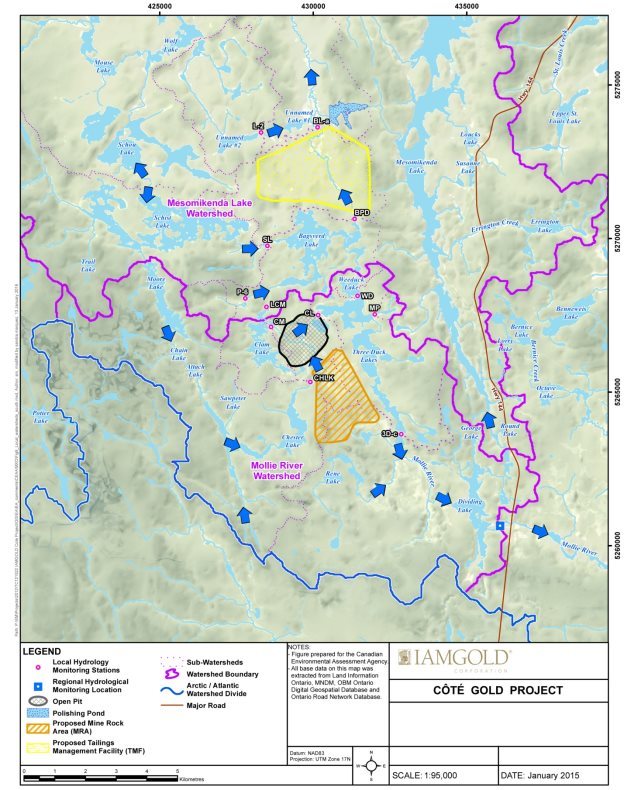
Source: IAMGOLD Corporation, January 2016.
6 Predicted Changes to the Environment
6.1 Water Quantity
This section outlines predicted changes to groundwater levels, surface water levels, and surface water flows due to the excavation of the open pit, watercourse realignments, construction of retention dams and the dewatering of Côté Lake.
The hydrogeology (groundwater) and hydrology (surface water) study areas are described in Table 1-3, in Subsection 1.2.3. Local watershed boundaries and existing flow directions are shown in Section 5.1 (Figure 5-1) and Appendix C (Figure C-1). Proposed watershed changes for each phase of the Project are described in more detail in Appendix C (Figure C-2 and Figure C-3).
6.1.1 Proponent's assessment of environmental effects
The proponent modelled potential changes to groundwater levels associated with the open pit (including the dewatering of Côté Lake), the mine rock area, the tailings management facility, seepage collection ponds, watercourse realignments and retention dams. The proponent also modelled potential changes to surface water levels and flows associated with the proposed watercourse realignments and development of project infrastructure, such as the tailings management facility and the open pit. The modeling accounted for seasonal and annual changes in flows, storage capacity in mine site ponds and the surrounding watersheds, and discharges from lakes around the mine site.
Anticipated effects
In the construction and operation phases, groundwater levels would be lowered as a result of excavation of the open pit and watercourse realignments. The proponent anticipates that changes in groundwater levels would be localized to the areas of these activities and would not cause direct adverse effects on fish habitat, land use or human health. Groundwater levels around the open pit would increase again as the pit fills with water during the decommissioning phase and stage 1 of the abandonment phase.
As described in Appendix C, the proponent intends to construct several retention dams and realign portions of the Mollie River and Bagsverd Creek during the construction phase. Predicted changes to surface water levels caused by these realignments are illustrated in Section 2.2 (Figure 2-2) and described below.
Decreases in the surface water levels of Little Clam Lake (by approximately 2.5 m) and Clam Lake (by approximately 0.9 m) would cause shallower basins and loss of shoreline, which could cause loss of fish habitat. Decreases in the surface water levels in Bagsverd Creek may affect fish passage. Surface water flow at the outflow of Bagsverd Lake into the realigned portion of Bagsverd Creek may be reduced by 16 percent. A maximum reduction of 20 percent would be predicted in the unaltered portion of Bagsverd Creek north of the proposed tailings management facility (downstream of Unnamed Lake #1), including at the final effluent discharge point in Neville Lake, at the outflow of Bagsverd Creek. Effects of the predicted surface water level changes on fish and fish habitat are discussed further in Section 7.1.
Increases in surface water levels are predicted at Bagsverd Lake South (by approximately 1.5 m), Chester Lake (by approximately 1.5 m) and Permanent Pond (by approximately 2.0 m). Flooding at Bagsverd Lake South may create conditions suitable for methylmercury production, as described further in Sections 6.4 and 7.4.
During the construction and operation phases, freshwater would be drawn from Mesomikenda Lake for potable water, truck washing and fire reserve requirements, and for use in the ore processing plant if there is insufficient water in the mine water pond. The freshwater to be drawn is not anticipated to change the surface water levels in Mesomikenda Lake, and is not discussed further in the Report.
In the decommissioning phase and stage 1 of the abandonment phase, water pumped from the ponds in the mine site, precipitation, and groundwater seepage would fill the open pit. Retention dams and watercourse realignments would remain in place, and surface water levels would remain similar to the operation phase.
In stage 2 of the abandonment phase, several dams would be removed to restore flow from Clam Lake (through the new pit lake) into Three Duck Lakes, and to restore flow from Bagsverd Lake South into Bagsverd Lake. Surface water levels in Little Clam Lake, Clam Lake, Bagsverd Lake South, Chester Lake and Permanent Pond would remain similar to the operation phase. Surface water flow rates at the outflow of Bagsverd Lake would increase again and be similar to baseline conditions, but would continue to flow through the realigned portion of Bagsverd Creek. Surface water flow in the unaltered portion of Bagsverd Creek would remain approximately 13 percent below baseline conditions, as contact water from the revegetated tailings management facility would passively discharge to Mesomikenda Lake. The potential for fish passage impedance in Bagsverd Creek during stage 2 of the abandonment phase is addressed in Section 7.1.
Proposed mitigation measures, monitoring and follow-Up
The proponent has proposed several measures to reduce the effects of the Project on water quantity. Those measures are listed in Appendix F and include:
- Construct realignment channels in a manner that would allow reasonably predicted surface water flows throughout all project phases to pass through without causing flooding or erosion.
- Recycle water on the mine site in a manner that reduces the volume of freshwater to be drawn from Mesomikenda Lake for ore processing.
The proponent is committed to several monitoring and follow-up measures related to water quantity to verify mitigation measures and to validate predictions during all project phases. These measures are detailed in Appendix F and include:
- Monitor groundwater levels around the open pit, mine rock area and tailings management facility.
- Monitor groundwater levels in the vicinity of surface water features to assess interactions between groundwater and surface water.
- Monitor surface water levels and flows in selected lakes, outflows and streams.
Anticipated residual effects
After the implementation of mitigation measures, the proponent anticipates surface water flow would decrease by approximately 20 percent relative to baseline conditions in the unaltered portion of Bagsverd Creek during the operation and decommissioning phases and stage 1 of the abandonment phase, and would decrease approximately 13 percent relative to baseline conditions in stage 2 of the abandonment phase (both of which are moderate in magnitude). These residual effects would be localized within the hydrology local study area (moderate in extent), occur during operations, during and after the open pit is filled with water (high in duration), and would occur continuously (high in frequency). The decrease in surface water flow would be partially reversible after the tailings management facility is revegetated. The anticipated decrease in surface water flow out of Bagsverd Lake during the operation phase would be fully reversed after retention dams are removed in the southern part of the lake.
Anticipated residual effects of changes to surface water levels are discussed in Section 7.1 in terms of alteration of aquatic habitat. They are also discussed further in Section 7.6, in terms of loss or alteration of water bodies related to federal decisions.
6.1.2 Views expressed
Government authorities
Environment and Climate Change Canada commented on uncertainties related to hydrology modelling, and advised that the models could be improved by incorporating baseline data from longer periods, with more seasonal representation and more locations. The proponent is of the view that the models are acceptable, and will be further refined as their monitoring activities continue. The Agency took into account the uncertainty with the hydrology models identified by Environment and Climate Change Canada in its analysis of predicted effects and the need for follow-up activities in relation to fish and fish habitat (Section 7.1) and methylmercury production (Section 7.4).
Natural Resources Canada commented on limitations in the proponent's characterization of groundwater movement in relation to the mine rock area, open pit, and tailings management facility, and related concerns about effects of the project on groundwater. Natural Resources Canada was generally satisfied with much of the information received from the proponent to address the concerns, but observed that some uncertainties remain in relation to the potential for seepage through the base of the tailings management facility. These uncertainties are described in Subsection 6.2.2 in relation to water quality, and addressed through key mitigation identified in Section 7.1, in relation to fish and fish habitat.
Aboriginal groups
The Métis Nation of Ontario requested monitoring of groundwater levels in the area near the open pit, and in locations where groundwater interacts with surface water at wetlands. The proponent indicated that additional monitoring locations may be added, if necessary, to supplement existing locations. In particular, the proposed monitoring program would include well nests to monitor interactions between groundwater and surface water. Any additional monitoring locations would be discussed with the Métis Nation of Ontario and other Aboriginal groups. The Métis Nation of Ontario is satisfied with the response.
6.2 Water Quality
This section outlines predicted changes to water quality from potential erosion during construction and from watercourse realignments, leaching of metals and ions from stockpiles of mine rock and other mining activities, seepage and run-off from various project components, and final discharge of effluent. The water quality study areas are identified in Table 1-3 of Subsection 1.2.3.
6.2.1 Proponent's assessment of environmental effects
The proponent's surface water quality models estimated water quality at mine site components, in receiving waters and downstream of the receiving water bodies. The models were built on the hydrogeology and hydrology models discussed in Section 6.1 and assumed fully developed mine site features, including the open pit, mine rock area and tailings management facility. The proponent does not anticipate water quality effects upstream of the mine site, and did not include upstream water bodies in the model. The proponent noted that groundwater discharges locally to surface water, or is collected in the open pit or seepage collection ponds. For this reason, changes to groundwater quality are captured in the surface water quality models.
Anticipated effects
The main cause of effects on water quality during the construction phase is erosion. Suspended solids may enter surface water bodies due to disturbance of soils from construction activities. In particular, realignment of the Mollie River and Bagsverd Creek may disturb soils and cause erosion. Increased levels of suspended solids in waterways, and changes in sediment deposition patterns, may impair fish passage or reduce the suitability of fish habitat, as discussed in Subsection 7.1.1.
During the operation phase, the main potential sources of contaminants include leaching from mine rock stockpiles, residues from the use of explosives, and residual cyanide from its use in the ore processing plant. The main potential pathways through which on-site contaminants might enter surrounding water bodies include uncontrolled seepage or run-off of contact water, and controlled effluent discharge at a final effluent discharge point that would be regulated under the Metal Mining Effluent Regulations by Environment and Climate Change Canada. The water management system at the mine site during the operation phase is described in Appendix D.
Metals and ions may leach from the mine rock area, overburden and low-grade ore stockpiles, exposed ore in the open pit, and project infrastructure such as the tailings management facility. The mine rock is generally considered to have low sulfides and a low potential for acid generation and metal leaching. The proponent predicts the mine rock would have a low potential for acid rock drainage. The proponent expects that the water that would percolate from mine rock and the contact water would also have near-neutral pH and may contain leached metals such as antimony, arsenic, cobalt, copper, iron, nickel, phosphorus and zinc in varying concentrations. Ammonia and nitrate may be present in the open pit, mine rock area and low-grade ore stockpile due to residues from explosives.
Water at the processing plant will contain cyanide from its use in the gold recovery process. Most of the cyanide would be removed from process water by a dedicated destruction circuit at the processing plant. Treated process water would be sent by pipeline to the tailings management facility, and the concentration of residual cyanide in tailings would be further decreased by exposure to sunlight and other natural processes in the tailings management facility reclaim pond.
A small volume of seepage would be anticipated through the perimeter and the base of the tailings management facility to Bagsverd Lake, Unnamed Lake #1, Unnamed Lake #2 and Bagsverd Creek. Seepage would also be anticipated from the mine water pond and mine rock area (which includes the mine rock and overburden stockpiles) to the open pit and to Chester Lake, Three Duck Lakes, Delaney Lake and the Mollie River. The proponent anticipates that seepage losses would be minimized with collection ponds and ditches around the tailings management facility, mine rock area and low-grade ore stockpile. Geomembrane liners would be used on starter dams at the perimeter of the tailings management facility and under the mine water pond and low-grade ore stockpile collection ponds to reduce seepage losses into the open pit.
From the polishing pond, effluent would be transported by a pipeline to the final effluent discharge point located in Neville Lake, at the outflow of Bagsverd Creek. As discussed in Section 7.1, the proponent anticipates that prior to effluent discharge, additional treatment may be needed to remove copper, iron and zinc to ensure that concentrations in the initial effluent mixing zone do not reach levels that may cause short-term effects to fish and aquatic life (see Table 6-1).
| Substance | Highest maximum predicted concentration in operation phase (mg/L) |
Provincial Water Quality Objectives (mg/L) |
Canadian Water Quality Guidelines for the Protection of Aquatic Life (mg/L) |
Ontario Drinking Water Standards (mg/L) |
Guidelines for Canadian Drinking Water Quality (mg/L) |
Metal Mining Effluent Regulations Schedule 4 limits (mg/L) |
|---|---|---|---|---|---|---|
| * Standards that are exceeded are bolded. "N/A" indicates that the particular standard does not exist for that substance. | ||||||
| Antimony | 0.00859 | 0.02 | N/A | 0.006 | 0.006 | N/A |
| Arsenic | 0.0247 | 0.005 | 0.005 | 0.025 | 0.01 | 0.50 |
| Copper | 0.0122 | 0.005 | 0.002 | N/A | N/A | 0.30 |
| Iron | 1.21 | 0.30 | 0.30 | N/A | N/A | N/A |
| Total phosphorus | 0.19 | 0.02 -0.03 | 0.02 | N/A | N/A | N/A |
| Zinc | 0.061 | 0.02 | 0.03 | N/A | N/A | 0.50 |
The proponent predicts that total phosphorus would exceed the Canadian Council of Ministers of the Environment's Canadian Water Quality Guidelines for Protection of Aquatic Life in Neville Lake and water bodies downstream of the initial effluent mixing zone. As discussed in Section 7.1, these increased phosphorus levels are not predicted to lead to eutrophication, which would be harmful to fish and aquatic species. Maximum concentrations of antimony and arsenic may also exceed Guidelines for Canadian Drinking Water Quality and the Ontario Drinking Water Standards under average and wet climate conditions within the initial effluent mixing zone during effluent discharge. However, as noted in Subsection 7.4.1, the proponent does not anticipate effects to human health from these exceedances.
Domestic sewage collected during the construction and operation phases would be treated by an on-site sewage treatment plant to meet standards from Ontario Ministry of the Environment and Climate Change's Environmental Protection Act. The treated sewage effluent could be discharged into the environment or recycled along with other waters on the mine site.
As described in Appendix C, during the decommissioning phase and stage 1 of the abandonment phase, the open pit would fill with water. Once the open pit is full, runoff from the mine rock area would be passively discharged into Delaney Lake, Chester Lake and Lower Three Duck Lake. Revegetation on the mine site would occur progressively, starting in the decommissioning phase. Any surface drainage from the revegetated tailings management facility and polishing pond would passively discharge towards the middle basin of Mesomikenda Lake and Bagsverd Creek, respectively. The proponent does not anticipate that any substance (Table 6-1) would occur at levels that may cause effects to fish and aquatic life during the decommissioning and abandonment phases.
Proposed mitigation measures, monitoring and follow-up
The proponent has proposed several measures to reduce the effects of the Project on water quality. Those measures are listed in Appendix F and include:
- Limit soil erosion and transport of sediments during all phases through best management practices.
- Include potentially acid-generating rock within the bulk of the mine rock area to avoid formation of acid rock drainage.
- Treat process water for cyanide at the ore processing plant during the operation phase, prior to discharge into the tailings management facility.
- Recycle process water and ensure no direct discharge occurs from the tailings management facility to the environment.
- Treat any effluent produced by the Project, if necessary, by a treatment unit prior to effluent discharge to the environment to ensure that levels of metals within the initial effluent mixing zone would not cause short-term effects to fish and aquatic life.
- Install low-permeable liners on starter dams at the tailings management facility to limit seepage losses during the operation phase.
- Construct collection ditches around the mine rock area, low grade ore and overburden stockpiles, and tailings management facility to capture and reuse surface drainage water, and reduce erosion and fine sediment input to fish habitat.
- Revegetate the mine rock area and dry areas of the tailings management facility in a progressive manner, during the decommissioning and abandonment phases.
The proponent is committed to several monitoring and follow-up measures related to water quality (Appendix F) to verify mitigation measures and validate predictions during all project phases. These include:
- Monitor surface water quality at collection ponds and potentially affected receiving water bodies, including downstream from Mesomikenda Lake and Dividing Lake, for over 60 parameters, metals and ions (see Appendix F for list) to meet the Canadian Council of Ministers of the Environment's Canadian Water Quality Guidelines for Protection of Aquatic Life and Ontario's Provincial Water Quality Objectives;
- Monitor levels of total suspended solids in surface water downstream of active construction areas on a daily basis during construction, to meet Canadian Water Quality Guidelines for Protection of Aquatic Life and Provincial Water Quality Objectives; and
- Monitor levels of metals in the mine rock in selected blast hole cuttings during the operation phase.
Anticipated residual effects
After the implementation of mitigation measures, the proponent anticipates that due to construction activities, average concentrations of total suspended solids would exceed baseline levels but remain below Canadian Council of Ministers of the Environment's Canadian Water Quality Guidelines for Protection of Aquatic Life and Provincial Water Quality Objectives (moderate in magnitude), confined to the local study area (moderate in extent), for all phases of the Project (high in duration). These exceedances are predicted to be intermittent, as construction activities occur (moderate in frequency), and fully reversible.
After the implementation of mitigation measures, the proponent anticipates that due to metal leaching and potential seepage losses through the tailings management facility, the average concentrations of copper, cobalt, nickel and cyanide in the Mesomikenda Lake subwatershed would exceed baseline levels, while remaining below Canadian Water Quality Guidelines for Protection of Aquatic Life and Provincial Water Quality Objectives (moderate in magnitude). The effects would extend to the outflow of the upper basin of Mesomikenda Lake, just beyond the boundary of the surface water quality local study area (high in extent). These exceedances from baseline levels would occur continuously (high in frequency) during the operation, decommissioning and abandonment phases (high in duration), and would be partially reversible in the operation phase and fully reversible in the decommissioning and abandonment phases.
In the Mollie River Subwatershed, the proponent anticipates that due to metal leaching, the average concentrations of copper, cobalt and nickel after the implementation of mitigation measures would exceed baseline levels, while remaining below Canadian Council of Ministers of the Environment's Canadian Water Quality Guidelines for Protection of Aquatic Life and Provincial Water Quality Objectives (moderate in magnitude), extending just beyond the boundary of the surface water quality local study area (high in extent), during the operation, decommissioning and abandonment phases (high in duration). Average concentrations of calcium and potassium in the Mollie River subwatershed would also exceed baseline levels (moderate in magnitude) during the abandonment phase; these substances do not have existing criteria under the Canadian Council of Ministers of the Environment's Canadian Water Quality Guidelines for Protection of Aquatic Life and Provincial Water Quality Objectives.
In Upper and Middle Three Duck Lake and Delaney Lake, the proponent anticipates that due to metal leaching, the average concentrations of total phosphorus after the implementation of mitigation measures would exceed baseline levels and Canadian Council of Ministers of the Environment's Canadian Water Quality Guidelines for Protection of Aquatic Life (high in magnitude), within the water quality local study area (moderate in extent) during operation, decommissioning and abandonment phases (high in duration). These residual effects would occur occasionally (moderate in frequency) and be fully reversible.
6.2.2 Views expressed
Government authorities
Environment and Climate Change Canada noted that the proposed watercourse realignment channels may cause accelerated erosion, particularly in cases of increased water flow, which may lead to more suspended solids in water bodies. The proponent indicated that the natural channel design being used for realignments would attenuate water flow in a manner that would prevent erosion. Environment and Climate Change Canada notes that the proposed realignment channels should not only be stable enough to minimize erosion to avoid adverse environmental effects to fish habitat, but should also allow for natural rates of erosion to maintain fish habitat. The proponent also included mitigation measures to prevent failure of realignments in case of accidents and malfunctions (Subsection 8.2.1), and has committed to monitoring total suspended solids in surface water bodies. The Agency understands that the proponent will require site approvals and engineering approvals for watercourse realignments from the Ontario Ministry of Natural Resources and Forestry under Ontario's Lakes and Rivers Improvement Act.
Natural Resources Canada commented that while the proponent has advanced its understanding of the geochemistry of mined materials through the environmental assessment process, additional information would be useful to demonstrate that analyzed samples are representative of the probable range in composition of ore, low grade ore and tailings. Natural Resources Canada, the Ontario Ministry of the Environment and Climate Change and the Ontario Ministry of Northern Development and Mines requested that the proponent incorporate all humidity cell testing data into its models of metal loading rates, including data from the first 20 weeks that the proponent had excluded from its models, or demonstrate that the metal leaching observed in the first 20 weeks is not representative of conditions that would be experienced throughout the life of the mine. The proponent indicated that the build-up of materials on the test materials while in storage is different from that of the rock in the waste rock pile, and the initial flushing of those built-up materials does not present a realistic estimate of metal loadings. The government authorities were not satisfied with the proponent's response, and note that the proponent will need to meet and fulfill any requirements set out in the provincial Closure Plan, with regards to characterizing, managing, monitoring and handling mined materials, including mine rock, low-grade ore and tailings, as required by the Ontario Ministry of Northern Development and Mines and pursuant to Ontario's Mining Act.
Natural Resources Canada is in general agreement with the proponent that the Côté deposit is a low sulphide deposit and believes that with due care and attention during the construction and operation phases, the mitigation required in the decommissioning and abandonment phases may be minimal with no need for active, long term chemical treatment. Natural Resources Canada and the Ontario Ministry of the Environment and Climate Change have recommended that the proponent develop a systematic process to mix potentially acid generating material, to provide assurance that discrete masses of acid generating material will not occur in the mine rock area. Natural Resources Canada also commented that the proponent should provide a contingency plan in the event that low-grade ore is not processed after the operation phase.
The proponent is of the view that the percentage of potentially acid-generating rock is small and well distributed throughout the overall mine rock. The proponent has committed to preparing a robust program for monitoring and managing potentially acid-generating rock prior to the start of the operation phase. The proponent also indicated that it does not foresee stockpiling any low-grade ore beyond the operation phase, and did not provide a contingency plan or additional mitigation measures to address this scenario. As with the humidity cell testing request, the government authorities and the Agency understand that the proponent will be expected to meet any requirements set out in the Closure Plan with regards to characterizing, managing, monitoring and handling mined materials, including mine rock, potential low-grade ore stockpiles and tailings, as required by the Ontario Ministry of Northern Development and Mines and pursuant to the Mining Act.
Environment and Climate Change Canada, Natural Resources Canada and the Ontario Ministry of the Environment and Climate Change indicated that the characterization of groundwater (including the groundwater flow model) used as an input for surface water quality predictions may not account for potential seepage losses through the base of the 840 ha tailings management facility. The proponent is of the view that it has produced a groundwater model that is conservative and accounts for all seepage losses through the tailings management facility that would go mainly into Bagsverd Creek, but could also go into Bagsverd Lake, Unnamed Lake #1 and Unnamed Lake #2. These government authorities indicated that a more detailed model of groundwater movement, informed with additional sample points within the area of the proposed tailings management facility, would be necessary to reduce high uncertainty about the magnitude and location of potential seepage losses through the base of the tailings management facility. In particular, Environment and Climate Change Canada is of the view that conclusions about effects on surface water quality due to seepage from the tailings management facility have not been adequately substantiated.
The Ontario Ministry of the Environment and Climate Change will require the proponent to obtain an Industrial Sewage Environmental Compliance Approval, pursuant to Ontario's Environmental Protection Act, before the Project begins. To obtain this approval, the proponent will need to collect additional geological and hydrogeological field data, and develop robust mitigation measures, seepage and groundwater monitoring programs, as well as contingency plans in case of seepage losses. The Agency accepts that the proponent has provided sufficient information to support the environmental assessment, and the government authorities and the Agency believe that the additional work required by the proponent to obtain the Environmental Compliance Approval will reduce uncertainty about the baseline conditions and efficacy of mitigation measures for seepage losses. The Agency has identified key mitigation for the proponent to manage water quality in mine effluents and surrounding water bodies, including by implementing measures to limit seepage losses from the tailings management facility, as necessary (described further in Subsection 7.1.3).
Environment and Climate Change Canada and the Ontario Ministry of the Environment and Climate Change raised concerns about the potential release of cyanide into the environment from the tailings management facility, or from effluent discharge from the polishing pond. The proponent noted that all process water containing cyanide would be treated at the ore processing plant before being directed to a central reclaim pond within the tailings management facility. Residual cyanide would be destroyed by exposure to sunlight in the tailings management facility reclaim pond. The proponent did acknowledge that a minimal quantity of residual cyanide could seep out of the tailings management facility, and accounted for that potential seepage loss in its surface water quality predictions. The proponent is of the view that no cyanide should be discharged from the polishing pond, as all water entering the polishing pond would come from the mine water pond, which would not contain cyanide. The proponent did acknowledge that cyanide could enter the polishing pond in the unlikely scenario of an overflow in the tailings management facility reclaim pond, due to an extreme precipitation event. The proponent anticipates that concentrations of cyanide in Bagsverd Lake, Unnamed Lake #1, Unnamed Lake #2, Bagsverd Creek and Neville Lake could intermittently exceed baseline levels due to seepage from the tailings management facility, while remaining below Canadian Council of Ministers of the Environment's Canadian Water Quality Guidelines for Protection of Aquatic Life and Provincial Water Quality Objectives.
Aboriginal groups
The Wabun Tribal Council and the Métis Nation of Ontario indicated that the proponent's use of average surface water quality from water bodies near the mine site to represent baseline conditions does not account for spatial and seasonal variations. The proponent responded that their baseline data set spans over two years and covers various climate and flow conditions. The proponent is of the view that its approach is conservative, and that the baseline surface water quality does not vary considerably between sites.
The Wabun Tribal Council and the Métis Nation of Ontario raised comments similar to that of government reviewers on the management of potentially acid generating and metal leaching rock. The proponent indicated that it is confident in the low net potential of mine rock to generate acid and leach metals.
The Wabun Tribal Council asked how the dewatering of Côté Lake into another water body would impact water quality in the receiving water bodies. The proponent notes that Côté Lake currently drains into Three Duck Lakes and that the water quality of both lakes is similar. It is of the view that the complete dewatering of Côté Lake to Three Duck Lakes during the construction phase would not cause adverse changes in the water quality in Three Duck Lakes. The proponent also noted that it had committed to best management practices to limit discharge of suspended solids during dewatering of Côté Lake.
The Métis Nation of Ontario requested additional surface water quality monitoring stations at the Bagsverd Lake realignment and along Bagsverd Creek downstream of the polishing pond, and for the creek leading from Dividing Lake to Mollie Lake. The proponent indicated that monitoring stations could be added to the monitoring program, and would discuss any additions with the Métis Nation of Ontario and other Aboriginal groups.
The Métis Nation of Ontario indicated that no clear contingency plan is provided for implementation should unacceptable water quality conditions occur in the open pit after it fills with water and the new pit lake is formed. The proponent noted that it committed to treating any outflow from the filled open pit, if required, to meet the Canadian Council of Ministers of the Environment's Canadian Water Quality Guidelines for Protection of Aquatic Life and Provincial Water Quality Objectives before discharge into the environment.
Further comments about water quality in relation to fish and fish habitat and human health are presented in Subsections 7.1.2 and 7.4.2, respectively.
Public
Northwatch Coalition for Environmental Protection raised comments similar to that of government reviewers on the selection of data used from humidity cell testing and the proposed mixing of potentially acid generating rock with the rest of the waste rock. It also commented on the geochemical characterization of tailings. The proponent is of the view that the bulk of the tailings would be non-acid generating with low sulphide and low metal content.
Northwatch Coalition for Environmental Protection asked how water quality would be assured by the proponent while the open pit fills after operations, as that would take at least 50 years. The proponent indicated that its water quality monitoring program includes the period during which the open pit fills, and noted that the Province of Ontario's Mining Act requires that a Closure Plan be filed and that financial assurance be provided to guarantee the proper closure of a mine, including long-term monitoring of water quality.
6.3 Atmospheric Environment
This section outlines predicted changes to air quality from emissions of dust and contaminants due to blasting, drilling, vehicles, ore processing and other activities. This section also outlines predicted changes to noise and vibration levels due to blasting and other mining activities.
6.3.1 Proponent's assessment of environmental effects
Anticipated effects from air quality and greenhouse gas emissions
The air quality local and regional study areas, given in Table 1-3 in Subsection 1.2.3, extend approximately 5 and 10 km, respectively, from the main project emission sources, including the tailings management facility, open pit and mine rock area. The proponent's air quality model considers expected sources of emissions, meteorological data, and site terrain and infrastructure over a five-year period at maximum operating conditions. The model does not explicitly consider emissions during the construction phase, as these would be lower and of shorter duration than emissions in the operation phase. The proponent has indicated that the property boundary for the Project will be informed by the air quality models to ensure that the Province of Ontario's Ambient Air Quality Criteria are met within the proposed boundary.
During the construction phase, the main sources of emissions would be dust and nitrogen oxides from site preparation activities such as drilling, blasting and truck movements. Dust emissions would also be anticipated from construction activities at the tailings management facility. Emissions associated with transmission line construction would be limited to heavy equipment operation, and would not be expected to cause adverse environmental effects.
During the operation phase, main sources of emissions include dust from drilling, blasting, transportation, material handling and ore processing. Dust emissions would also be anticipated from exposed areas of the tailings management facility. Nitrogen oxide emissions would be anticipated from blasting, equipment exhaust and emergency generators. Hydrogen cyanide emissions would be anticipated from ore processing, although in-plant destruction would minimize release of cyanide to the atmosphere. The proponent would restrict blasting activities to a one-hour window per day (1:00 p.m. to 2:00 p.m.), when meteorological conditions are most favourable to limit atmospheric dispersion.
The proponent anticipates that 1-hour average concentration of nitrogen dioxide, and 24-hour average concentrations of total suspended particulate, particulate matter (PM10) and fine particulate matter (PM2.5) may exceed the Province of Ontario's Ambient Air Quality Criteria or the Canadian Ambient Air Quality Standards at locations at and near the mine site. Based on the information provided by the proponent, 24-hour average concentrations of fine particulate matter (PM2.5) and 1-hour average concentrations of nitrogen dioxide may exceed Ontario's Ambient Air Quality Criteria up to five percent of the year over some portions of the 4M Circle Canoe Route, including western portions of Three Duck Lakes and eastern portions of Clam Lake. The frequency of exceedances for 24-hour average concentrations of total suspended particulate and particulate matter (PM10) over these lakes should be similar. The proponent anticipates that maximum 24-hour average concentrations of hydrogen cyanide may approach Ontario's Ambient Air Quality Criteria limit at the proposed property boundary, but it did not indicate any exceedances over the 4M Circle Canoe Route. Potential health effects from exposure to these conditions are described in Subsection 7.4.1.
The proponent used dispersion modelling to predict rates of total particulate (dust) deposition in areas along the traditional and 4M Circle Canoe routes, and in areas where potential traditional resource harvesting may occur. A maximum deposition rate of 39.7 grams per square meter per year is anticipated along the canoe route near Middle Three Duck Lake. The proponent did not predict changes to soil quality from deposition of dust, and therefore did not analyze the potential for contamination of traditional plants. The presence of dust may decrease the quality of migratory bird habitat, as discussed in Subsection 7.2.1.
During the decommissioning phase, the main sources of air emissions would be dust from dismantling of project infrastructure and truck traffic. Dust emissions from the tailings management facility would occur during the decommissioning phase and a portion of the abandonment phase, until it is revegetated. The proponent anticipates that all parameter concentrations would be below the Canadian Ambient Air Quality Standards and Ontario's Ambient Air Quality Criteria during the decommissioning and abandonment phases, and no adverse effects to human health or migratory birds would be predicted during these phases.
The proponent evaluated the anticipated greenhouse gas emissions during the operation phase. The assessment considered direct emissions from sources owned or controlled by the company (e.g. combustion of fuel in boilers, furnaces, vehicles) and indirect emissions from generation of purchased electricity, heat or steam. The Project would have fluctuating levels of annual greenhouse gas emissions. The proponent anticipates maximum annual greenhouse gas emissions of 285 818 tonnes of carbon dioxide-equivalent emissions in year eight of the operation phase; which is equivalent to approximately 0.17 percent and 0.04 percent of greenhouse gas emissions, in Ontario and Canada, respectively, based on 2011 emissions levels. The proponent's assessment did not analyze upstream greenhouse gas emissions associated with the Project. For projects in the metal mining sector, the Agency's analysis indicates that these types of projects have negligible upstream greenhouse gas emissions when compared to the direct project emissions. As a result, the Agency's analysis of the effects of greenhouse gas emissions is on the direct emissions attributable to the Project.
Anticipated effects from noise and vibration
The noise and vibration local and regional study areas extend approximately 5 and 10 km, respectively, from the main project noise sources (including the tailings management facility, open pit and mine rock area), and 1 km on either side of the transmission line alignment. Noise levels were modelled for both the construction and operation phases, separately for daytime (7:00 a.m. to 7:00 p.m.) and nighttime (7:00 p.m. to 7:00 a.m.), since the criteria of the environmental noise guideline (NPC-300) of the Ontario Ministry of the Environment and Climate Change differ for each period of the day. Blasting noise and vibration levels were assessed using the Ontario Ministry of the Environment and Climate Change's Blasting Noise and Vibration Model (NPC-119), and were incorporated into the ambient noise models. The proponent modelled noise and vibration levels at 28 selected sensitive receptor locations (cottages, recreation access points and tourist areas) within the noise and vibration regional study area.
The proponent's noise models did not include the construction of the transmission line. A forest buffer would be retained as practicable to reduce noise effects to nearby land users. The proponent expects that the majority of construction activities along the transmission line corridor would occur during the winter season for short periods of time.
During the construction phase, the main sources of noise would be from use of machinery during construction activities at the open pit (including blasting), mine rock area, tailings management facility, watercourse realignments and from truck routes within the mine site. Activities at the mine site would be expected to occur 24 hours per day, although drilling would be limited to daytime hours, blasting activities would be restricted to a one-hour window per day (1:00 p.m. to 2:00 p.m.), and truck traffic would be reduced during nighttime hours. Daytime noise levels during the construction phase are predicted to remain below the NPC-300 limit of 45 A-weighted decibels. Nighttime noise levels during the construction phase may exceed the NPC-300 limit of 40 A-weighted decibels at the two cottages that are closest to the tailings management facility, approximately 1.1 and 1.6 km away. Blasting noise levels would be expected to remain at or below the NPC-119 limits. Increases in noise levels may decrease the quality of habitat for migratory birds; these effects are discussed in Subsection 7.2.1. Blasting vibration levels may be perceptible at some of the selected sensitive receptor locations, but are not predicted to cause structural damage. Vibrations from blasting may affect fish spawning in Clam Lake; these effects are described in Subsection 7.1.1.
During the operation phase, the main sources of noise would be from mining operations at the open pit (including blasting and equipment operation), activities at the ore processing plant, and truck routes within the mine site. As during the construction phase, activities at the mine site are anticipated to occur 24 hours per day, with similar restrictions on drilling and blasting during daytime, and truck traffic during nighttime. Daytime and nighttime noise levels during the operation phase are anticipated to remain below NPC-300 limits. Nighttime noise levels would be lower during the operation phase since construction activities at the tailings management facility would be completed. Blasting noise levels would remain at or below the NPC-119 limits. Blasting vibration levels may be perceptible at some of the selected sensitive receptor locations, but are not predicted to cause structural damage. Similar effects to migratory birds from increase to noise levels and to fish spawning at Clam Lake from vibrations may occur during the operation phase.
During the decommissioning and abandonment phases, the main sources of noise would be from activities involving the demolition of project infrastructure (during the decommissioning phase); truck traffic; revegetation of the mine rock area, tailings management facility and polishing pond; and pumping of water into the open pit. Some noise would also come from the dismantling of watercourse realignments and dams. Work activities in these phases would be limited to daytime hours. Daytime noise levels during the decommissioning and abandonment phases are predicted to be lower than during the construction phase, and therefore, would remain below provincial noise limits. No nighttime activities or blasting activities are anticipated during these phases.
Proposed mitigation measures, monitoring and follow-up – air quality and greenhouse gas emissions
The proponent has proposed several measures to reduce the effects of the Project on air quality. Those measures are listed in Appendix F and include:
- Implement a dust best management plan that would:
- identify all potential sources of dust, including at the tailings management facility;
- use dust collection systems to reduce dust and metals emissions during operations; and
- detail inspection and recordkeeping to ensure dusts are effectively managed.
- Implement an engine maintenance program during the construction, operation and decommissioning phases to control emissions of nitrogen oxides from generators, trucks and off-road mobile equipment, including compliance with Environment and Climate Change Canada emission requirements for trucks and off-road mobile equipment.
- Destroy cyanide at the ore processing plant to minimize potential hydrogen cyanide emissions before tailings are released to the tailings management facility.
- Restrict blasting during the construction and operation phases to allow it between 1:00 p.m. and 2:00 p.m only.
- Calculate greenhouse gas emissions annually to identify opportunities to reduce emissions.
The proponent is committed to several monitoring and follow-up measures related to air quality, to verify mitigation measures and to validate predictions. These measures are detailed in Appendix F and include:
- Monitor total suspended particulates and metals to ensure compliance with Ontario Regulation 419/05: Air Pollution—Local Air Quality during construction and operation phases.
- Monitor nitrogen dioxide during construction and operation phases.
- Monitor dust deposition in areas where plant harvesting may occur.
- Monitor energy consumption from activities of the Project to calculate annual greenhouse gas emissions.
Proposed mitigation measures, monitoring and follow-up – noise and vibration
The proponent has proposed several measures to reduce the effects of project activities on noise and vibration. Those measures are listed in Appendix F and include:
- Maintain a minimum separation distance of 1 km between construction activity locations and nearby receptors to reduce noise and vibration.
- Maintain a minimum separation distance of 1.25 km between blast locations and the nearest receptors to reduce blasting noise and vibration.
- Limit the operation of some equipment to daytime hours only during the construction, operation and decommissioning phases, and reduce haul truck use at night.
- Purchase cottages where exceedances of NPC-300 nighttime criteria may occur, if necessary.
The proponent is committed to several monitoring and follow-up measures related to noise and vibration to verify mitigation measures and to validate predictions. These measures are detailed in Appendix F and include:
- Monitor hourly noise levels at receptors that are closer than 1 km from construction activities to ensure that Ontario Ministry of the Environment and Climate Change's NPC-300 criteria are not exceeded.
- Monitor blasting noise and vibration levels at the closest receptor location during construction and operation phases to ensure that Ontario Ministry of the Environment and Climate Change's NPC-119 criteria are not exceeded.
Anticipated residual effects from air quality
After the implementation of mitigation measures, the proponent anticipates that the concentrations of 24-hour total suspended particulate, particulate matter (PM10), fine particulate matter (PM2.5), nitrogen dioxide and annual fine particulate matter (PM2.5) would exceed the province of Ontario's Ambient Air Quality Criteria or Canadian Ambient Air Quality Standards (high in magnitude) during the operation phase. These exceedances would occur at and near the mine site, within the air quality local study area (moderate in extent), and during the operation phase for up to 15 years (moderate in duration). Any exceedances of these guidelines would occur intermittently (moderate in frequency), and would be expected to be fully reversible once the operation phase ends.
Anticipated residual effects from noise and vibration
After the implementation of mitigation measures, the proponent anticipates that during the construction phase nighttime noise levels would exceed baseline levels and the Ontario Ministry of the Environment and Climate Change's NPC-300 criteria (high in magnitude) at some locations in the noise and vibration local study area, including two cottages located 1.1 and 1.6 km from the tailings management facility (moderate in extent) for up to two years (low in duration). During the operation phase, the proponent anticipates that nighttime noise levels would exceed baseline levels but remain below the NPC-300 criteria limits (moderate in magnitude) within the noise and vibration local study area (moderate in extent) for approximately 15 years (moderate in duration). In both phases, nighttime noise effects would occur frequently (high in frequency) and would be fully reversible. No nighttime noise is anticipated during the decommissioning and abandonment phases.
After the implementation of mitigation measures, the proponent anticipates that daytime noise levels would exceed baseline levels but remain below NPC-300 criteria limits (moderate in magnitude) within the noise and vibration local study area (moderate in extent) for the construction, operation and decommissioning phases (high in duration). These residual effects in all phases would occur frequently (high in frequency) and would be fully reversible.
After the implementation of mitigation measures, the proponent anticipates that both blasting noise levels and vibration levels would exceed baseline levels, while remaining below NPC-119 criteria limits (moderate in magnitude), within the noise and vibration local study area (moderate in extent). These effects from blasting activities would occur during construction and operation phases (high in duration), at regular intervals (moderate in frequency), and would be fully reversible. No blasting activities are anticipated during the decommissioning and abandonment phases.
6.3.2 Views expressed
Government authorities – air quality
Environment and Climate Change Canada, Health Canada and the Ontario Ministry of the Environment and Climate Change noted that the air quality models only incorporated the operation phase of the Project, and requested that the models also include activities from the construction phase. The proponent indicated that activities in the construction phase are similar to the operation phase, with lower activity levels and emissions. The proponent also noted that the air quality model assumed the worst year of emissions for each parameter for every year simulated by the model, thus providing a conservative estimate of air quality for the Project. The government authorities are satisfied with the response. Environment and Climate Change Canada requested additional measures, including a fugitive dust best management plan to identify all potential sources of fugitive dusts and outline mitigation measures to control dust generation, and the submission of an ambient air quality monitoring program to Environment and Climate Change Canada prior to the start of the construction phase for implementation starting in the construction phase.
Environment and Climate Change Canada requested that the proponent's proposed ambient air monitoring program include real-time monitoring of total suspended particulates, particulate matter (PM10), fine particulate matter (PM2.5), metals, nitrogen dioxide (to represent nitrogen oxides) and sulphur dioxide during site preparation, construction and operation phases, in order to verify short term impacts and validate modelling results. The proponent responded that an air monitoring plan would be submitted to the Ontario Ministry of the Environment and Climate Change for their approval. The proponent expects the plan would require monitoring of total suspended particulates, particulate matter (PM10), metals, and passive monitoring of nitrogen dioxide and sulphur dioxide. Fine particulate matter (PM2.5) would be analyzed as a fraction of the measured particulate matter (PM10). Environment and Climate Change Canada indicated that it was satisfied with the response.
Government authorities – noise and vibration
The Ontario Ministry of the Environment and Climate Change noted that potential changes related to on-site aggregate pits were not included in the noise model. The proponent updated the model to include these effects, and concluded that it did not change the magnitude of effects on the selected sensitive receptors. The Ontario Ministry of the Environment and Climate Change is satisfied with this response.
Health Canada noted that additional vehicle traffic in the construction and operation phases, to and from the mine site and on Highway 144, was not included in the noise modelling. The proponent compared existing traffic to predicted traffic during these phases and found a negligible increase in noise levels at the nearest cottage location. Health Canada is satisfied with this response.
Health Canada indicated that the noise associated with the construction of the transmission line was not included in the noise model, and that the proponent's proposal to retain a forest buffer would not make an effective noise barrier. The proponent agreed with these comments, but noted that construction noise for the transmission line alignment would occur for a short duration during the erection of each tower. The proponent would provide noise monitoring when construction activity is near sensitive receptors, and would implement additional mitigation measures if unexpected noise impacts occur. Health Canada is satisfied with this response.
Aboriginal groups
Comments received from Aboriginal groups about air quality, noise and vibration related to potential health and socio-economic effects are presented in Subsection 7.4.2.
6.4 Terrestrial Landscape
This section describes predicted changes to the terrestrial landscape from the direct removal of vegetation (i.e. vegetation clearing), dewatering activities, and watercourse realignments causing habitat loss and habitat fragmentation in the project footprint.
The terrestrial biology study areas for the mine site and for the transmission line are given in Table 1-3 in Subsection 1.2.3.
6.4.1 Proponent's assessment of environmental effects
Anticipated effects from vegetation clearing
The proponent anticipates that during the construction phase, the construction at the mine site of the open pit, tailings management facility, mine rock area, overburden stockpile, access roads, and storage facilities would result in the removal of 1567.8 ha of upland and wetland vegetation. Upland habitat includes coniferous, deciduous, and mixed forest communities. Wetlands consist of open bog, treed bog, treed fen and wetland habitat types. A summary of habitat loss (by habitat type) for the mine site in relation to the available habitat in the terrestrial biology local and regional study areas is shown in Table 6-2.
| Habitat Type | Area removed in constructing the mine site (ha) | Percent loss of available habitat type in local study area | Percent loss of available habitat type in regional study area |
|---|---|---|---|
| *N/A indicates that the habitat type is not found in the specified spatial boundary | |||
| Bog – open | 0.0 | 0.0 | 0.0 |
| Bog – treed | 30.5 | 29.0 | 0.3 |
| Fen – treed | 0.0 | 0.0 | 0.0 |
| Forest – dense coniferous | 257.3 | 12.7 | 0.3 |
| Forest – dense deciduous | 17.9 | 10.0 | 0.1 |
| Forest – dense mixed | 705.2 | 15.3 | 0.5 |
| Forest – sparse | 88.3 | 20.3 | 0.4 |
| Forest Depletion – cuts | 240.2 | 17.6 | 0.9 |
| Jack Pine Regeneration/Cut | 29.3 | 13.2 | 10.8 |
| Settlement/Infrastructure | N/A* | N/A* | 0.0 |
| Water – deep clear | 22.0 | 1.5 | 0.1 |
| Wetland | 177.1 | 28.0 | 10.6 |
| Total | 1567.8 | --- | --- |
The proponent also anticipates that the construction of the transmission line alignment will remove 549.2 ha of forested communities, which includes 232.9 ha of deciduous mixed forest, 170.3 ha of coniferous forest, and 146 ha of coniferous swamp. Along the transmission line alignment there are 26 ha of wetland and aquatic communities (12.3 ha of tall shrub swamp, 1.8 ha of low shrub fen, 8.1 ha of narrow leaved emergent marsh, and 3.8 ha of open water bodies). However, the proponent indicated little or no wetland or aquatic habitat (excluding coniferous swamp) would be directly lost from construction of the transmission line alignment.
The terrestrial landscape within the terrestrial biology study areas are suitable habitats for migratory birds (Section 7.2) and wildlife species (Section 7.6), including species at risk (Section 8.1). The removal of vegetation could cause direct habitat loss, alteration, and fragmentation that may result in decreased habitat quality. Fragmentation can influence several ecological processes that lead to changes in population distribution and abundance, including plant and wildlife dispersal between fragments, wildlife movement between foraging areas and increased disturbance and predation along habitat edges. Changes in wildlife populations are not predicted in the terrestrial biology local or regional study areas. The removal of vegetation may cause soil erosion that has the potential to affect water quality (Section 6.2), fish habitat (Section 7.1) and human health (Section 7.4). In addition, changes in the terrestrial landscape may have impacts on the current use of lands and resources for traditional purposes (Section 7.3) and the physical and cultural heritage of Aboriginal peoples (Section 7.5).
Disturbed areas within the project footprint are to be rehabilitated throughout the decommissioning and abandonment phases to promote vegetation growth and reduce potential erosion. Areas to be revegetated include non-flooded pit slopes, 25 percent of the mine rock area, the low-grade ore stockpile, dry areas of the tailings management facility, polishing pond, and access roads. Chemical use will be avoided for controlling vegetation growth, in order to allow for the natural recovery of vegetation communities and avoid related impacts on human health. As a result, the proponent predicts adverse effects related to habitat loss and fragmentation to be minimal and confined to the project footprint.
Anticipated effects from dewatering and watercourse realignments
The dewatering of water bodies such as Côté Lake, and the realignment of watercourses within the terrestrial biology local study area may affect the abundance of upland habitat by changing the quality of the vegetation and causing loss of some habitat.
As described in Subsection 6.1.1, the construction of watercourse realignments will involve flooding areas of Chester Lake and Bagsverd Lake South, which may cause terrestrial vegetation decay. This decay could allow anaerobic bacteria to convert mercury in the soils to methylmercury once it is flooded, releasing methylmercury into water and exposing fish to contamination. The proponent has committed to removing terrestrial vegetation and organic soils around Bagsverd Lake South prior to flooding to mitigate the potential for methylmercury production. The removed soils would be stored in the overburden stockpile in the mine site. The proponent notes that a 1.5 m increase in water levels at Chester Lake will lead to minimal flooding of surrounded areas of the lake. The flooded area will be less than 40 cm in depth and surface water conditions would remain oxic. The proponent predicts the flooding would be within typical ranges found during seasonal flooding of the surrounding area, such that any vegetation decay would also occur within typical ranges. As a result, the proponent does not anticipate increased methylmercury production in Chester Lake. The proponent also predicts increased water levels at Permanent Pond, however, minimal vegetation would be flooded and increased methylmercury production is not anticipated. As a result, possible methylmercury production at Permanent Pond will not be discussed further in the Report. Potential effects of consuming contaminated fish on human health are discussed in Section 7.4.
Proposed mitigation measures, monitoring and follow-up
The proponent has proposed several measures to reduce changes to the terrestrial landscape. Those measures are listed in Appendix F and include:
- Develop a compact project footprint, including minimized width of the transmission line alignment and limited construction of new roads and other corridors wherever possible.
- Minimize vegetation clearing in the project footprint during the construction phase, which includes retaining existing low-lying vegetation along the transmission line alignment.
- Implement rehabilitation and progressive revegetation of disturbed habitat, using locally-sourced plant species that are native to the landscape, during all project phases.
- Avoid, where practical, placement of structures in water bodies along the transmission line alignment and low-lying areas to limit adverse effects to wetlands.
- Remove soil (i.e. organic layer of soil and terrestrial vegetation) surrounding Bagsverd Lake South that may potentially release methylmercury into the water body prior to flooding areas for watercourse realignments.
The proponent has not identified any necessary monitoring and follow-up activities for the terrestrial landscape.
Anticipated residual effects
After the implementation of mitigation measures, the proponent anticipates residual effects from habitat loss and fragmentation due to vegetation clearing, dewatering activities, and watercourse realignments. The proponent indicates that the residual effects would cause no measurable change to the abundance and distribution of plant populations and communities (low in magnitude), and would be restricted to the project footprint (low in geographic extent) during the construction, operation and decommissioning phases over approximately 19 years (high in duration). The residual effects would occur continuously (high frequency), and would be fully reversible for the vegetation communities along the transmission line alignment and partially reversible for the upland community types and wetlands with revegetation.
6.4.2 Views expressed
Government authorities
Environment and Climate Change Canada, Natural Resources Canada and the Ontario Ministry of the Environment and Climate Change requested that the proponent provide additional baseline information on the mercury level in soils to clarify required mitigation for potential methylmercury production in various water bodies to be flooded. The proponent is of the view that its commitment to remove the organic layer of soil at Bagsverd Lake South, prior to flooding the terrain, would be sufficient to mitigate methylmercury production such that soil baseline information is not necessary. Additional comments from government authorities on the proposed mitigation, and the Agency's analysis, are described in Section 7.4 in relation to the health of Aboriginal peoples.
Aboriginal groups
The Métis Nation of Ontario commented that areas to be flooded for watercourse realignments may have the potential for methylmercury production from decaying vegetation. The proponent's response is the same as those provided to government authorities as described previously.
The Wabun Tribal Council and the Métis Nation of Ontario expressed concern about potential adverse effects to wetlands. The Métis Nation of Ontario requested that all wetlands in the terrestrial biology local and regional study areas be explicitly identified and effects predicted for each. The proponent assessed effects on wetlands and determined that adverse effects would be low for the mine site and that little to no wetland habitat would be directly lost from the transmission line alignment.
7 Predicted Effects on Valued Components
7.1 Fish and Fish Habitat
This section describes potential adverse effects on fish and fish habitat including direct loss of habitat and individual fish loss, effects to fish spawning and passage, and effects from contaminated surface water on fish. These effects may occur due to the development of the Project, including construction and dismantling of watercourse realignments, blasting activities, and changes in water flow and surface water quality. The aquatic biology study areas are described in Table 1-3, in Subsection 1.2.3.
7.1.1 Proponent's assessment of environmental effects
Anticipated effects from construction activities and dismantling of watercourse realignments
During the construction phase, the development of the open pit, tailings management facility, mine rock area, and the associated watercourse realignments will involve complete loss of fish habitat in Côté Lake, Beaver Pond, North Beaver Pond, East Beaver Pond, Unnamed Pond, and Clam Creek, and partial loss of fish habitat in Clam Lake, the east arm of Upper Three Duck Lake, the Mollie River, Chester Lake, Bagsverd Lake and Bagsverd Creek, as shown in Section 2.2 (Figure 2-2). As a result, critical lifecycle requirements (such as spawning, juvenile rearing, adult foraging, and over wintering) of the resident fish, including northern pike, yellow perch, walleye, whitefish, and smallmouth bass may be affected. In addition, the loss of aquatic habitats would require the removal of fish from these habitats and relocation into newly created habitat, which may cause the loss of individual fish. The created habitats may not be fully functional to support fish until the end of the first year of the operation phase, causing a lag time in the formation of suitable habitat such that some resident fish may experience interrupted access to habitat or reduction in habitat quality.
Watercourse realignments for the Mollie River around the mine rock area, and for Bagsverd Creek around the tailings management facility, are anticipated to create both riparian stream and lake fish habitat. As described in Section 6.1, increases in water levels would cause flooding at Bagsverd Lake South, Chester Lake, and Permanent Pond. Water levels are predicted to be lower at Clam Lake and Little Clam Lake, which will result in a shallower basin and exposed shorelines causing some riparian habitat to be lost.
During stage 2 of the abandonment phase, the removal of several dams to reconnect Clam Lake to the new pit lake and on to Upper Three Duck Lake, as described in Section 6.1, may potentially cause a loss of fish and fish habitat that had been previously established after the damming of Clam Lake and Upper Three Duck Lake during the construction phase. There may be a lag time after removal of the dams before suitable habitat is available for fish. Table 7-1 summarizes riparian stream and lake habitat loss and gain as a result of the Project.
| Habitat type | Construction Phase | Abandonment Phase | |
|---|---|---|---|
| Development of Project Components | Watercourse realignment | Dismantling of watercourse realignments | |
| Riparian stream habitat | Loss of 14 610 m of total length and 14 ha of total area, based on measured stream widths | Loss of 1325 m in stream habitat (1.1 percent of stream habitat length and 1.6 percent of stream habitat area) | Possible small loss of stream habitat from increased flows |
| Riparian lake habitat | Loss of 55 ha of total area | Gain of 3 ha in lake habitat (0.1 percent of lake habitat area) | Open pit is proposed to fill and then be reconnected to the Mollie River, to provide an additional 14 ha of lake habitat |
The proponent anticipates the overall loss of fish from the development of the mine site and watercourse realignments to be relatively small with minimal population effects. Fish will be relocated within the same watershed. The proponent also anticipates the net change in fish habitat to be small in the aquatic biology local study area, with no loss of productive fish habitat. Any serious harm to fish and fish habitat, taking into consideration lag times for habitat to be functional, will be addressed through an offsetting plan under the Fisheries Act.
Anticipated effects from blasting activities
During the construction phase and the early years of the operation phase (until the pit is deeper than 350 m below the lake bottom), noise and vibration from blasting in the open pit (as described in Section 6.3) could affect the quality and use of fish habitat in the southern basin of Clam Lake nearest to the open pit, thereby reducing the spawning success by resident fish. However, smallmouth bass is the dominant fish species in this water body, and there is an abundance of spawning habitat for this species along the west and north shore of Clam Lake. Direct effects on individual fish are not anticipated and effects related to spawning habitat are predicted to be minimal. The area potentially affected by blasting activities is primarily too deep and is of limited value for fish spawning. Any spawning habitat in Clam Lake that is found to be affected by blasting activities will be addressed in the fish offsetting plan under the Fisheries Act.
Anticipated effects from changes in water flow
As described in Section 6.1, reductions in flow of up to 20 percent in relation to baseline levels are anticipated at the outflow of Bagsverd Lake into the realigned portion of Bagsverd Creek during the operation, decommissioning and stage 1 of the abandonment phases until the open pit is filled with water, and in the unaltered portion of Bagsverd Creek, north of the tailings management facility, during the operation, decommissioning and both stages of the abandonment phase, including after the filling of the new pit lake. These flow reductions may limit the use of some habitat and impact fish passage within Bagsverd Creek, especially in shallow riffle areas located near the mouth of the creek. Reduction of fish passage may lead to decreased fish health and reproductive success. In cases of high flows, natural channels that are downstream of realignments and receiving more water may experience erosion, causing the release of suspended solids and fine sediment that may also limit fish passage. Impairment on fish passage will be accounted for as part of the fish offsetting plan under the Fisheries Act. As a result, adverse effects on fish passage are predicted to be low.
Loss of individual fish may occur during the operation phase as a result of the intake of freshwater from Mesomikenda Lake, which may occasionally cause resident fish to be drawn into the intake pipe or subsequently caught on the intake screen.
Anticipated effects from changes in surface water quality
Potential sources of contaminants on surface water quality in aquatic environments near the mine site and their predicted effect on fish are summarized in Table 7-2.
As described in Section 6.2, the release of suspended solids from watercourse realignments, leaching of metals and ions from stockpiles of mine rock, blast waste and residual explosives (e.g. ammonium and nitrate), seepage (e.g. metals and cyanide), and discharge of effluent into Neville Lake, at the outflow of Bagsverd Creek, all have the potential to affect surface water quality in aquatic environments near the mine site. The proponent indicated the mine site water (contact water and seepage) would be collected and recycled for use in the processing plant, and as necessary discharged into Neville Lake, at the outflow of Bagsverd Creek, while following the requirements of the Metal Mining Effluent Regulations. For use in the operation phase, the proponent has proposed developing site-specific water quality objectives with the Province of Ontario. Alternately the proponent has proposed to undertake additional treatment prior to effluent discharge, through an effluent treatment plant if necessary, to ensure concentrations of copper, iron and zinc within the initial effluent mixing zone do not result in short-term effects to fish and aquatic life, such as decreased reproductive success.
The proponent anticipates increases in total phosphorus concentrations in Neville Lake, and Upper and Middle Three Duck Lake. While this could create favourable conditions for eutrophication, the proponent does not expect material changes in dissolved oxygen in the water for resident biota, or a shift in the productivity of fish populations in these lakes. Therefore, the proponent does not expect harm to fish caused by increased phosphorus levels. The proponent anticipates that the average concentrations of several metals and ions (including copper, cobalt, nickel and cyanide) will exceed baseline levels in water bodies near the Project, but does not expect adverse effects to fish from these exceedances. Consumption of fish in these water bodies is not predicted to result in effects to human health.
Another potential source of contamination on water quality is methylmercury that may be produced from flooding of Bagsverd Lake South and Chester Lake (Subsections 6.1.1 and 6.4.1) during the construction and operation phases. Fish species in both lakes include yellow perch, northern pike, white sucker, and lake whitefish. Walleye is also found in Bagsverd Lake South. The decay of terrestrial vegetation caused from flooding of these lakes during the construction of watercourse realignments may increase production of methylmercury, which may be taken up by resident fish. The proponent anticipates that methylmercury production in Chester Lake is not likely since the predicted increases in water levels caused by the Project are predicted to be within seasonal ranges for the lake, which would limit new decay of vegetation that would otherwise contribute to methylmercury production. For Bagsverd Lake South, the proponent commits to removing terrestrial vegetation and organic soil where flooding would occur to limit the conditions favourable for methylmercury production. The proponent does not anticipate harm to fish life as a result of methylmercury production. Also, no additional restrictions on human consumption of these fish would be needed. However, if it is determined through fish tissue monitoring that methylmercury levels are found to exceed consumption limits, restrictions on human consumption would be imposed. Section 7.4 describes aquatic toxicity as it relates to Aboriginal health and socio-economic conditions.
| Potential source | Associated infrastructure or activity | Project phases | Predicted change in water quality | Affected areas | Predicted effect on fish |
|---|---|---|---|---|---|
| Uncontained runoff of contact water | Open pit, mine rock and overburden stockpiles, watercourse realignments, construction of infrastructure | Construction, operation, decommissioning and abandonment | Increase in total suspended solids in contact water, primarily related to soil disturbances causing erosion | Mollie River Subwatershed and Mesomikenda Lake Subwatershed | No harm predicted |
| Uncontained runoff of contact water | Mine rock and overburden stockpiles, low-grade ore stockpile, open pit, project infrastructure | Construction, operation, decommissioning and abandonment | Increase in contaminants from metal leaching, increase in acid generation (e.g. 7% potentially acid generating mine rock), increase in residual explosives and blast waste (e.g. ammonium and nitrate) | Mollie River Subwatershed | No harm predicted |
| Uncontained seepage | Open pit, mine rock and overburden stockpiles, mine water pond | Operation, decommissioning, abandonment | Increase in contaminants (metals) | Mollie River Subwatershed | No harm predicted |
| Uncontained seepage | Tailings management facility | Operation, decommissioning, abandonment | Increase in contaminants (metals and cyanide) | Mesomikenda Lake Subwatershed | No harm predicted |
| Controlled effluent discharge | Initial effluent mixing zone in the lower basin of Neville Lake | Operation | Copper, iron, and zinc could periodically exceed water quality guidelines, in which case the proponent would apply additional treatment to reduce the concentration of these metals | Mesomikenda Lake Subwatershed (Neville Lake, at the outflow of Bagsverd Creek) | No harm predicted, given that additional treatment would be implemented if necessary |
| Controlled effluent discharge | Downstream of initial mixing zone | Operation | Total phosphorus exceeds water quality guidelines | Neville Lake | No harm predicted, given that eutrophication is not expected |
| Vegetation decay | Flooding of water bodies after watercourse realignments | Construction, operation | Methylmercury production | Bagsverd Lake South | No harm predicted |
Proposed mitigation measures, monitoring and follow-up
The proponent has committed to implementing mitigation measures, monitoring, and follow-up related to water quantity (Section 6.1), water quality (Section 6.2) and terrestrial landscape (Section 6.4). The proponent has also proposed several measures to reduce effects on fish and fish habitat. Those measures are listed in Appendix F and include:
- Implement an offsetting plan for serious harm to fish from the Project, including spawning habitat in Clam Lake. This program is to be developed with Fisheries and Oceans Canada in accordance with the Fisheries Act, and through engagement with Aboriginal groups.
- Implement a compensation plan for fish habitat losses related to mine water disposal under the Metal Mining Effluent Regulations, for submission to Environment and Climate Change Canada.
- Install screens in intake pipes to prevent drawing of fish from water intake structures.
- Construct collection ditches around the waste rock, low grade ore and overburden stockpiles, and tailings management facility to capture and reuse surface drainage water, and to reduce erosion and fine sediment input to aquatic environments.
- Treat any effluent produced by the Project, if necessary, prior to effluent discharge to the environment, to meet the discharge limits approved by the relevant provincial and federal authorities that are protective of aquatic life.
- Compare predicted reductions in flow to the measured stream morphology and modify the stream bed accordingly, as required to ensure fish passage and utilization of habitats.
The proponent is committed to the monitoring and follow-up activities related to fish and fish habitat. These activities are listed in Appendix F and include:
- Monitor the stream morphology of Bagsverd Creek and modify the stream bed as required to ensure no productive fish habitat is lost.
- Monitor the levels of total suspended solids and turbidity in surface waters downstream of active construction area to ensure federal and provincial water quality objectives are met.
- Monitor surficial sediment, benthic invertebrate community, fish community, and fish health to ensure federal and provincial water quality objectives are met.
Predicted residual effects
After mitigation, the proponent anticipates residual effects on fish and fish habitat from the alteration and disruption of existing fish habitat, from blasting activities on the quality and use of the adjacent spawning habitat in Clam Lake, and from changes in water quality due to leaching of metals and ions. These residual effects would be low to moderate in magnitude (i.e. habitat loss less than 10 percent of stream and lake habitat, no measurable residual effects on a recreational fishery, 10 to 30 percent change in surface water flow, and median concentrations less than guidelines or less than chronic toxicity thresholds for substances without guidelines) and the geographic extent would be restricted to the aquatic biology local study area. Residual effects would occur during all Project phases (high in duration), occur continuously (high in frequency), and would be partially reversible.
The proponent anticipates that residual effects from alteration or disruption of habitat and changes in water quantity would occur for all project phases (high in duration), occur continuously (high in frequency), and be fully reversible for habitat changes and partially reversible for changes in water quantity, with the exception of Bagsverd Creek where residual effects are irreversible since flow reduction would be permanent. Changes in water quality would occur intermittently during the construction phase and continuously from the operation phase to the abandonment phase (moderate to high frequency), and be fully reversible. Residual effects on spawning habitat associated with blasting in the open pit adjacent to Clam Lake would occur during the construction and operation phases (high in duration), occur intermittently (moderate in frequency), and be fully reversible.
The net residual effect on fish and fish habitat would be low in magnitude and geographic extent, high in duration, moderate to high in frequency, and partially to fully reversible. The proponent considers the residual adverse effects on fish and fish habitat as not likely to be significant.
7.1.2 Views expressed
Government authorities
Fisheries and Oceans Canada commented on the effectiveness of the mitigation measures proposed given the substantial amount of fish habitat to be lost or altered from the dewatering of Côté Lake and watercourse realignments. The proponent proposed a conceptual offsetting plan designed to ensure the destruction or permanent alteration of habitat is replaced by habitat of similar quantity and quality. Key design considerations included: maintenance of the existing hydrology flow regime, to the extent possible; promotion of connectivity within watersheds and habitats; natural channel design and features to convey water flows and prevent erosion; enhanced habitat complexity; and incorporation of limiting habitat types for resident fish, to the extent possible. Proposed measures to minimize lag times before the habitat is fully productive included: physical structures to support spawning; vegetation planting; invertebrate transplanting; and staged relocation of fish. Fisheries and Oceans Canada confirmed it supports the proposed conceptual approach to offsetting serious harm to fish. Final designs of the offsetting plan components are required by Fisheries and Oceans Canada before determining that the plan will offset residual serious harm to fish, to meet the requirements of the Fisheries Act.
Fisheries and Oceans Canada and Environment and Climate Change Canada commented on the potential adverse effects to fish and fish habitat at the decommissioning and abandonment phases as a result of removing the dams in order to dismantle the watercourse realignments, and indicated that there would be an associated lag time in useable habitat. The proponent is committed to working with Fisheries and Oceans Canada to determine suitable fish habitat that would offset serious harm to fish. The proponent has proposed to mitigate all habitat altered or destroyed during the decommissioning and abandonment phases through newly constructed or enhanced fish habitat provided by the flooded open pit, and by restoring the channels that would have connected Clam Lake to the flooded open pit to Upper Three Duck Lake. Taking into consideration the lag time in habitat functionality, fish would not be relocated until there is useable fish habitat as required by the offsetting plan. Fisheries and Oceans Canada and Environment and Climate Change Canada are satisfied with the proponent's response and have informed the Agency that at the time the watercourse realignments are to be dismantled and dams removed, and for the new filled pit lake to be considered as suitable fish habitat, the proponent must apply for a new Fisheries Act authorization that includes an assessment of the functionality of fish habitat. It is noted that the new filled pit lake is not part of the current Fisheries Act authorization.
Fisheries and Oceans Canada requested monitoring of spawning habitat near blasting activities during the construction and operation phases, in particular in the southern basin of Clam Lake. The proponent would include monitoring of spawning habitat in its offsetting plan proposal under the Fisheries Act authorization. Fisheries and Oceans Canada is satisfied with the proponent's response.
Fisheries and Oceans Canada expressed concerns about the predicted effects to Bagsverd Creek in from reduced flows and to fish as a result of potential changes to fish passage through stream reaches with the shallowest flows. The proponent provided additional information on the predicted changes to water levels in Bagsverd Creek. Fisheries and Oceans Canada agreed that the predicted water level reductions caused by the reduced flows in Bagsverd Creek would not likely result in a barrier to fish migration in a low water flow scenario, and that additional monitoring would be required to verify this through the Fisheries Act authorization.
The Ontario Ministry of the Environment and Climate Change indicated that information from the proponent did not clearly demonstrate that the preferred alternative for effluent discharge location and design, and the level of effluent treatment (i.e. proposed maximum concentration limits), would minimize the mixing zone size and result in the least potential for adverse aquatic effects, including toxicity. It has requested additional information from the proponent to better understand the potential aquatic environmental effects of the effluent discharge into Neville Lake at the outflow of Bagsverd Creek, and to increase certainty that proposed mitigation measures would be adequate.
Aboriginal groups
The Métis Nation of Ontario requested additional information on the timing of construction and operation activities, and the interaction of these activities with fish and fish habitat. The proponent indicated that while the exact construction start dates and timelines are not known, they committed to ongoing consultations on the timing of site construction including avoidance of in-water works during spawning periods. The proponent has also committed to working with Aboriginal groups and Fisheries and Oceans Canada to develop an offsetting plan to mitigate adverse effects to fish and fish habitat, including fish spawning habitat that may be affected by blasting activities.
Public
Northwatch Coalition for Environmental Protection requested that the proponent include monitoring of fish population and abundance in the local study area as part of the monitoring program for fish. The proponent indicated that fish population and abundance would be monitored as part of the federal monitoring requirements under the Fisheries Act.
Northwatch Coalition for Environmental Protection also commented that in addition to northern pike and yellow perch, walleye and lake whitefish should also be relocated to newly constructed habitats associated with the watercourse realignments. The proponent indicated that all species of fish found in each of the areas to be lost from project development will be relocated to newly constructed habitat. Walleye and lake whitefish will be relocated to suitable habitat within the same watershed, and will be relocated to Upper Three Duck Lake if captured in Côté Lake and the arm of Upper Three Duck Lake since these areas are continuous.
7.1.3 Agency analysis and conclusion
Analysis of the effects
The Project is predicted to cause direct loss and alteration to fish and fish habitat from the development of the open pit, mine rock area, and tailings management facility, and from the dewatering of Côté Lake and the construction and dismantling of watercourse realignments. Fish will be relocated from lost habitats to newly constructed habitat to mitigate losses of individual fish. Pursuant to the Fisheries Act, the proponent will implement an offsetting plan to counterbalance any unavoidable serious harm to fish. In addition, the proponent will implement a compensation plan for any fish habitat losses related to mine waste disposal for the Project pursuant to the Metal Mining Effluent Regulations. As part of the offsetting plan, effects causing serious harm to fish will be accounted for, including the loss of fish and fish habitat, disturbances to spawning habitat due to blasting activities, and impairment on fish passage due to changes to surface water flow. The Agency understands that the Fisheries Act authorization will include monitoring to confirm and ensure the effectiveness of the newly constructed habitat and other provisions in the offsetting plan. The proponent and Fisheries and Oceans Canada are committed to engaging with potentially affected Aboriginal groups during the Fisheries Act application and regulatory process.
The Agency notes uncertainty expressed by Environment and Climate Change Canada about the potential for accelerated erosion in and downstream of the realignment channels (described in Subsection 6.2.2). This includes the portion of Bagsverd Creek north of the tailings management facility that will not be realigned. The Agency understands that the Fisheries Act authorization will also include monitoring to confirm that fish passage is possible and fish habitat is maintained in both the realigned channel segments and natural channel segments downstream of realigned channels, during all project phases.
To limit adverse effects to fish in water bodies along the transmission line alignment in accordance with the Fisheries Act, the proponent will avoid in-water works so as not to interfere with fish passage, constrict channel width, or reduce flows. The Agency is of the view that these measures would be sufficient to mitigate adverse environmental effects on fish and fish habitat through all project phases. While there is uncertainty related to the prediction of effects on fish and fish habitat during the decommissioning and abandonment phases, including in relation to the proponent's plans to dismantle watercourse realignments once the open pit has been filled in 50 to 80 years after mine operations, the Agency considered the potential for future authorizations under the Fisheries Act in advance of the decommissioning and abandonment phases, and is of the view that those requirements would protect fish and fish habitat.
To limit adverse effects to fish from exposure to contaminated water, the proponent has proposed a water management and treatment approach, described in Appendix D that would capture and contain seepage and recycle as much mine water as possible on the mine site. A circuit in the process plant would be used to destroy cyanide in the process water that was used in ore processing, before it can be released to the tailings management facility to minimize release of cyanide into the environment via seepage from the tailings management facility. To address uncertainties about seepage through the perimeter and base of the tailings management facility (see Subsections 6.1.1 and 6.2.1), the Agency has identified key mitigation for the proponent to manage water quality in mine effluents and surrounding water bodies, including by implementing measures to limit seepage losses from the tailings management facility, as necessary.
Effluent would only be discharged from the polishing pond into Neville Lake, at the outflow of Bagsverd Creek, when necessary due to excess water in the polishing pond. The end-of-pipe discharge would not exceed the authorized limits of deleterious substances under Schedule 4 of the Metal Mining Effluent Regulations, which is protective of fish. The proponent proposes using, if necessary, an additional effluent treatment plant at the polishing pond to ensure that concentrations within the initial effluent mixing zone remain below toxicity thresholds for all substances, and reduce potential short-term effects to fish and aquatic life. The Agency is of the view that these described measures would be effective in ensuring that changes in water quality would not affect fish and fish habitat in any significant manner. In relation to predicted increases in phosphorus concentrations in Neville Lake and Upper and Middle Three Duck Lake, the Agency agrees with the proponent's assessment that no harm to fish is predicted due to eutrophication. The Agency notes that the proponent will work with the Ontario Ministry of the Environment and Climate Change to develop receiver-based effluent discharge criteria consistent with provincial water quality management policies and provincial water quality objectives.
The Agency acknowledges the adverse residual effects on fish and fish habitat after the implementation of an offsetting plan for serious harm to fish and a fish habitat compensation plan, the proponent's water management and treatment approach, and its compliance with the Metal Mining Effluent Regulations (Appendix B). The magnitude of the effects would be low to moderate considering that serious harm to fish would be offset and compensation will be provided for lost habitat. The geographic extent of the effects would be localized and would not impact the Mesomikenda Lake and Mollie River subwatersheds at a regional scale. The duration of the effects would be long-lasting given that they would persist into the abandonment phase, with the exception of residual effects on fish spawning from noise and vibration due to blasting activities that would be moderate in duration (occurring during construction and operation phases). Residual effects would occur continuously, with the exception of residual effects of noise and vibration on fish spawning from blasting that would occur intermittently. Residual effects are predicted to be fully reversible, except that adverse effects on fish passage would be irreversible at Bagsverd Creek where decreases in surface water flows will occur at all phases of the Project.
Key mitigation measures to avoid significant effects
The Agency has considered the mitigation measures proposed by the proponent, expert advice from federal authorities, and comments received from Aboriginal groups and the public in recommending the following key mitigation measures (Appendix G) for inclusion in the Minister's Decision Statement:
- Mitigation for loss of fish and fish habitat, and effects to fish spawning and fish passage
- Implement an offsetting plan for any serious harm to fish caused by the Project, pursuant to the Fisheries Act, and a fish habitat compensation plan for any fish habitat losses related to mine water disposal for the Project, pursuant to section 27.1 of the Metal Mining Effluent Regulations. Ensure any spawning habitat in Clam Lake that will be subject to increased noise and vibrations from blasting in the open pit is accounted for in the offsetting plan. These plans would be developed with Fisheries and Oceans Canada and with Environment and Climate Change Canada, and through engagement with Aboriginal groups.
- Relocate fish to newly created habitats prior to causing loss of existing habitat, taking into consideration all lifecycle requirements for all fish species, and minimizing mortality and stress to fish.
- Construct realignment channels in a manner that will provide or maintain the necessary habitat and environmental conditions (including water flows and levels, and channel erosion rates reflective of natural conditions) in both the realigned channels and the natural channels downstream of realigned channels, including between Bagsverd Lake and Neville Lake, for the critical lifecycle requirements of resident fish, and will allow for fish passage throughout all phases of the Project.
- Time construction activities outside of fish spawning and egg incubation periods, to the extent practical, and implement erosion control measures, including erosion control fencing and sedimentation catchments downstream of active construction areas.
- Avoid in-water works along the transmission line alignment, to the extent practical. Where not practical, follow appropriate guidance from Fisheries and Oceans Canada to avoid and mitigate causing serious harm to fish.
- Mitigation for effects to fish from changes in water quality
- Manage water quality in mine effluents to meet the Metal Mining Effluent Regulations, and in all water bodies surrounding the Project to meet the requirements of the Fisheries Act while taking into account the Canadian Council of Ministers of the Environment's Canadian Water Quality Guidelines for Protection of Aquatic Life. This includes, but may not be limited to:
- distributing waste rock in the mine rock area in a manner that minimizes acid generation and metal leaching.
- implementing measures to reduce the release of contaminants from blast waste and residual explosives, such as ammonium and nitrate, in the open pit, mine rock area, and low-grade ore stockpile.
- treating process water in a manner that removes cyanide prior to discharge to the tailings management facility.
- implementing measures to limit seepage losses from the tailings management facility, as necessary.
- collecting contact water and seepage from the tailings management facility, mine rock area, low-grade ore stockpile, and open pit in a manner that will prevent the release of untreated effluent into the environment.
- maximizing the recycling of water to reduce the frequency and duration of effluent discharge.
- treating contact water and seepage collected at the mine site, as necessary.
- treating any effluent produced by the Project, as necessary; this may include use of a treatment unit prior to effluent discharge to the environment.
- Manage water quality in mine effluents to meet the Metal Mining Effluent Regulations, and in all water bodies surrounding the Project to meet the requirements of the Fisheries Act while taking into account the Canadian Council of Ministers of the Environment's Canadian Water Quality Guidelines for Protection of Aquatic Life. This includes, but may not be limited to:
Need for and requirements of follow-up
The Agency has not identified a need for a follow-up program with respect to fish and fish habitat. The effectiveness of the offsetting plan for serious harm to fish will be monitored and ensured through the requirements of the Fisheries Act authorization. With respect to effluent and water quality, the proponent would have to implement measures, as necessary, to comply with the Metal Mining Effluent Regulations, which includes environmental effects monitoring, and with the Fisheries Act. The provincial Environmental Compliance Approval (described in Subsection 6.2.2) will include seepage and groundwater monitoring programs, as well as contingency plans in case of seepage losses.
Conclusions
Taking into account the implementation of the key mitigation measures identified in this section the Agency is of the view that the Project would not likely result in significant adverse environmental effects on fish and fish habitat.
7.2 Migratory Birds
This section describes the potential adverse effects to migratory birds, including direct suitable habitat loss and fragmentation causing displacement, loss of and disturbance to individual birds, eggs and nests, and the potential for lower reproductive rates. These effects may occur from vegetation clearing and habitat alteration, water flow and level changes causing flooding, sensory disturbances (i.e. artificial light, sound, and human presence), and collisions with vehicles.
Migratory birds listed under the Migratory Birds Convention Act, 1994 that may experience effects as a result of the Project are considered in the assessment, including: olive-sided flycatcher, common nighthawk, eastern whip-poor-will, Canada warbler, and chimney swift. All five species are listed as threatened under Schedule 1 of the Species at Risk Act. Barn swallow, bobolink, and eastern meadowlark are also included in the assessment because they are listed for consideration as endangered by the Committee on the Status of Endangered Wildlife in Canada, and may eventually be scheduled under the Species at Risk Act.
The terrestrial biology local and regional study areas for the mine site and transmission line alignment are described in Table 1-3 of Subsection 1.2.3.
7.2.1 Proponent's assessment of environmental effects
Anticipated effects
The proponent predicts that the anticipated effects on migratory birds will not be specific to individual bird species. As a result, the assessment of effects is reported on all migratory bird species collectively.
Anticipated effects from vegetation clearing and habitat alteration
As described in Section 6.4, vegetation clearing will be required at the mine site during the construction phase, and mine site infrastructure will result in a loss of terrestrial habitat. Construction activities that result in habitat loss and fragmentation are predicted to have potential adverse effects on migratory bird movement, causing displacement at an individual level.
Habitat fragmentation and the loss of interior woodland habitat from construction along the transmission line alignment are predicted to be minimal due to existing clear cut areas, replanted areas from past logging activities, and a large regenerating area. However, the additional open terrain and exposed woodlands may cause adverse effects to bird nests and eggs and an increased risk of mortality from predators such as raptors and foxes. As a result, some species may potentially abandon the area. In addition, individual birds outlined in Table 7-3 may be displaced and territory size may be impacted for individuals that have home ranges overlapping the transmission line alignment.
The proponent anticipates adverse effects to migratory birds from vegetation clearing and habitat alteration resulting in a loss of suitable habitat in the project footprint to be minimal, with no population effects as the loss of habitat in relation to the available suitable habitat in the regional study area is low. To reduce the predicted adverse effects to migratory birds, the proponent proposes to minimize the amount of vegetation clearing and to revegetate disturbed areas, throughout all project phases.
| Migratory bird | Suitable habitat type | Mine site | Transmission line alignment | ||
|---|---|---|---|---|---|
| Suitable habitat loss (ha) | Percent of known suitable habitat lost in local study area | Percent of known suitable habitat lost in regional study area | Suitable habitat loss (ha) | ||
|
†Vegetation limited by forestry activities |
|||||
| Olive-sided Flycatcher |
|
328.5 | 18.3 | 0.6 | 168.9 |
| Common Nighthawk and Eastern Whip-Poor-Will |
|
328.5 | 18.3 | 0.6 | 403 |
| Canada Warbler |
|
1040.2 | 14.6 | 0.4 | 233 |
| Chimney Swift |
|
N/A † | N/A † | N/A§ | N/A† |
| Barn Swallow |
|
N/A‡ | N/A † | N/A§ | N/A‡ |
| Bobolink and Eastern Meadowlark |
|
N/A‡ | N/A † | N/A§ | N/A‡ |
When vegetation clearing is underway during the construction phase, some individual bird mortality may occur, and their eggs and nests may be disturbed or destroyed from grubbing and clearing activities. The proponent anticipates adverse effects to migratory birds from individual bird mortality and loss of or harm to eggs and nests due to vegetation clearing activities in the project footprint to be minimal, with no population effects. To reduce the predicted adverse effects to migratory birds, the proponent has committed to avoid removing vegetation, including at the transmission line alignment, during the sensitive migratory bird nesting season (May 1 to August 15).
Anticipated effects from changes to water flows and levels
During the construction phase, the dewatering of Côté Lake and realigning of portions of Chester Lake, Clam Lake, Three Duck Lakes, and Bagsverd Creek will cause changes in water flows and water levels that may result in the flooding of ground and shoreline areas where bird nests and eggs occur. The proponent proposes to undertake work that would alter water levels outside of the migratory bird nesting season (May 1 to August 15) and to grub vegetation prior to flooding to limit the potential for effects on nesting birds. The proponent expects that there will be no adverse effects for migratory birds that feed on fish from the affected water bodies, because with the development of an offsetting plan for fish, there are no predicted adverse effects on fish availability (distribution and abundance) from changes to water flows and levels.
Anticipated effects from sensory disturbances
Disturbances from human presence, dust, artificial lights, and noise may decrease the quality of migratory bird habitat, and alter movement and behaviour. Human presence and excess dust may discourage birds from using nearby habitat during project phases, primarily during the construction and operation phases. Artificial light pollution may be a deterrent for some birds but an attractant for nocturnal species, including common nighthawk and eastern whip-poor-will. As described in Section 6.3, blasting activities and use of machinery at the mine site are predicted to be the main sources of noise during the construction and operation phases. Increases in noise levels may result in decreased breeding success or bird density. Noise produced during construction of the transmission line alignment is predicted to be temporary, and would occur during the winter months when migratory birds are not present. The proponent anticipates effects from sensory disturbances on migratory birds to be minimal, and proposes to prohibit project employees from hunting, feeding and harassing migratory birds.
Anticipated effects from collisions with vehicles
During the construction and operation phases, due to increased project traffic, there may be increased migratory bird mortality rates from collisions with vehicles. The proponent anticipates this effect to be minimal, and proposes to reduce speed limits on project roads and prohibit off-road use of vehicles for recreational purposes.
Proposed mitigation measures, monitoring and follow-up
The proponent has proposed several mitigation measures to reduce effects on migratory birds. Those measures are listed in Appendix F and include:
- Implement rehabilitation and progressive revegetation of disturbed habitat, using locally-sourced plant species that are native to the landscape, during all project phases.
- Avoid removing vegetation during sensitive migratory bird nesting season (May 1 to August 15).
- Minimize vegetation clearing and implement revegetation, where practical, throughout all project phases to progressively reduce the amount of disturbed habitat.
- Construct the transmission line alignment outside of the migratory bird nesting season (May 1 to August 15).
- Undertake work that would alter water levels outside of the migratory bird nesting season (May 1 to August 15) and grub vegetation prior to flooding to limit the potential of effects on nesting birds.
- Prohibit project employees from hunting, feeding and harassing migratory birds.
- Reduce speed limits on project roads and prohibit off-road use of vehicles for recreational purposes.
The proponent is committed to monitoring and follow-up activities related to migratory birds. These activities are listed in Appendix F and include:
- Monitor the presence of nests in any areas planned for disruption in the project footprint and complete nest surveys in the unforeseen circumstance that minor vegetation removal is necessary or if water levels need to be altered during the breeding or nesting season (May 1 to August 15), throughout project phases.
Predicted residual effects
After mitigation measures are applied, the proponent anticipates residual effects on migratory birds from habitat loss and fragmentation, individual bird mortality and loss of, or harm to, eggs and nests due to vegetation clearing activities, sensory disturbances, and collisions with vehicles and transmission lines. These residual effects would be low in magnitude (i.e. no measurable residual effect to population and distribution). The geographic extent would be moderate as effects extend into the terrestrial biology local study area. The frequency of all effects due to vegetation clearing activities would be high as effects are predicted to occur during the construction, operation, and decommissioning phases continuously; but it would be low for individual bird mortality and loss of or harm to eggs and nests as effects are predicted to occur once during the construction phase. Residual effects would be partially reversible within the mine site and fully reversible along the transmission line alignment after measures such as revegetation; however, the residual effects from individual bird mortality and loss of or harm to eggs and nests due to vegetation clearing activities would be irreversible. It should be noted that the proponent has indicated that revegetation activities will begin in the decommissioning phase and carry through into stage 1 of the abandonment phase. The proponent considers the residual adverse effects on migratory birds as not likely to be significant.
7.2.2 Views expressed
Government authorities
Environment and Climate Change Canada requested that the proponent implement additional mitigation measures and monitoring due to the potential for increased mortality to common nighthawk caused by collisions with vehicles and infrastructure. Environment and Climate Change Canada is satisfied with the proponent's commitment to record the presence of common nighthawk within the terrestrial biology local study area, and to report any sighting of the species within 24 hours to Environment and Climate Change Canada and the Ontario Ministry of Natural Resources and Forestry to determine whether any further action is required.
Environment and Climate Change Canada is of the view that artificial light from the Project may attract nocturnal migratory birds such as common nighthawk and eastern whip-poor-will, which would increase opportunities for collisions with vehicles and infrastructure. As a result, Environment and Climate Change Canada recommends an additional mitigation measure to manage mine site lighting for all project phases to avoid attracting nocturnal species.
Environment and Climate Change Canada requested that a noise analysis based on a 50 A-weighted decibel threshold, with comparison to habitat types, be used to determine the effect of the Project on local bird populations. The proponent completed the requested noise analysis and anticipates that approximately 0.7 percent of the total predicted number of birds in the terrestrial biology regional study area may be adversely affected by noise levels greater than or equal to 50 A-weighted decibels. Environment and Climate Change Canada is satisfied with the proponent's analysis.
Aboriginal groups
The Métis Nation of Ontario is of the view that the Project may result in changes to migratory bird distribution patterns as a result of disturbances such as habitat fragmentation, changes in water quality and quantity, and noise. The proponent took into account the changes in the physical environment in its assessment of environmental effects on migratory birds and anticipates adverse effects to be minimal.
7.2.3 Agency analysis and conclusion
Analysis of the effects
The Project is predicted to cause loss and fragmentation of suitable habitat, direct loss and harm to birds, their eggs and nests, and alterations to bird movement and behaviour from sensory disturbances.
The Agency notes the proponent's commitments to minimize vegetation clearing to the extent practical and to revegetate areas. The Agency also notes that not all areas will be fully revegetated; approximately 25 percent of the mine rock area and only dry areas of the tailings management facility are predicted to be revegetated. These revegetation activities will begin in the decommissioning phase and continue into stage 1 of the abandonment phase. Areas that will not be revegetated will potentially result in a loss of suitable habitat. The proponent anticipates that revegetation activities will begin a natural process, allowing all fragmented areas to potentially convert to suitable migratory bird habitat over an extended period of time.
The Agency is satisfied that loss and harm to birds, their eggs and nests would be limited by the proponent's commitment to implement vegetation clearing and alter water levels outside of the migratory bird nesting season, and grub vegetation in the area prior to flooding to avoid breeding effects and loss of eggs in ground and shoreline nests. The Agency has identified key mitigation for the proponent to take into consideration Environment and Climate Change Canada's Avoidance Guidelines and guidance on the General Nesting Periods of Migratory Birds in Canada, which are linked to the federal guide entitled Incidental Take of Migratory Birds in Canada.
The Agency is of the view that sensory disturbances to migratory birds would be minimal. Reducing speed limits for vehicles on project roads and access roads, and limiting off-road use of vehicles would limit migratory bird mortality from vehicle collisions. The Agency recognizes Environment and Climate Change Canada's advice that there may be indirect effects to nocturnal migratory birds, such as common nighthawk and eastern whip-poor-will, from vehicle collisions. The Agency also notes that these species feed on insects concentrated around light sources, and may be attracted to artificial light. The Agency has identified key mitigation measures to manage mine site lighting fixtures and is satisfied that these would adequately mitigate this effect on nocturnal birds.
The Agency is of the opinion that the adverse residual effects on migratory birds would not be significant with implementation of mitigation measures Appendix B). The Agency considers the residual effects on migratory birds to be low in magnitude with consideration taken for bird breeding timing restrictions. Residual effects are localized in geographic extent and the majority of these effects are predicted during all project phases. Blasting noise and vibration are predicted to occur during the construction and operation phases only. Residual effects from vegetation clearing and alteration would occur continuously but be partially reversible in the mine site and fully reversible along the transmission line alignment due to progressive revegetation. Residual effects from sensory disturbances would occur intermittently, and be fully reversible. Residual effects from mortality from vehicle collisions would occur infrequently and be irreversible.
Key mitigation measures to avoid significant effects
The Agency has considered the mitigation measures proposed by the proponent, expert advice from federal authorities, and comments received from Aboriginal groups in recommending the following key mitigation measures (Appendix G), for inclusion in the Minister's Decision Statement:
- Avoid harming, killing or disturbing migratory birds, or destroying, disturbing or taking their nests or eggs, taking into account the Environment and Climate Change Canada's Avoidance Guidelines. This includes:
- Avoid clearing vegetation, grubbing, and conducting vegetation clearing surveys, during the migratory bird core nesting periods, taking into consideration Environment and Climate Change Canada's guidance entitled the General Nesting Periods of Migratory Birds in Canada.
- Realign watercourses during the winter period to avoid destruction of bird nests and eggs caused by water flow and level changes.
- Manage lighting in the project footprint to avoid attracting nocturnal species, such as common nighthawk and eastern whip-poor-will.
Need for and requirements of follow-up
The Agency has recommended the follow-up program below (Appendix G), for inclusion in the Minister's Decision Statement:
- Develop a migratory bird follow-up program prior to construction, and implement the program during all project phases to verify the effectiveness of the mitigation measures used to avoid harm to migratory birds, their eggs and nests, including the management of mine site lighting.
Conclusions
Taking into account the implementation of the key mitigation measures identified in this section the Agency is of the view that the Project would not likely result in significant adverse environmental effects on migratory birds.
7.3 Aboriginal Peoples – Current Use of Lands and Resources for Traditional Purposes
This section describes the potential effects of changes to the environment caused by the Project on the current use of lands and resources for traditional purposes by Aboriginal peoples including effects to plant harvesting, hunting and trapping, fishing, and navigation. Aboriginal traditional land and resource uses in the local and regional study areas have been described in Section 5.2. Local and regional study areas for current use of lands and resources are based on the aquatic and biological study areas described in Table 1-3 in Subsection 1.2.3, depending on the type of traditional use being assessed.
The Wabun Tribal Council (on behalf of the Mattagami First Nation and the Flying Post First Nation) and the Métis Nation of Ontario completed traditional knowledge and traditional land use studies. The proponent incorporated the Wabun Tribal Council study into its impact assessment. Due to the timing of the submission of Métis Nation of Ontario study, the information made available was reviewed and considered by the proponent after its impact assessment had been completed. The sites and areas described as being of importance to both Wabun Tribal Council and the Métis Nation of Ontario within the aquatic and biological study areas have been identified in Figure 7-1 and Figure 7-2.
7.3.1 Proponent's assessment of environmental effects
Anticipated effects to traditional plant harvesting
Traditional plant harvesting may be affected by the project footprint overlapping traditional plant resources and harvesting areas and through changes to the abundance of quality plant resources. Potential environmental changes associated with vegetation removal and areas to be revegetated are described in Subsection 6.4.1.
During the construction phase, vegetation clearing along the transmission line right-of-way may result in the loss of traditional plant resources including blueberries in Sensitive Areas C, D, E, and potentially F, and in areas of reported Métis traditional knowledge and land use. In addition, losses of traditional plant resources may also occur in areas overlapped by the mine site.
During the operation phase, removal of additional traditional plant harvesting areas is not predicted. However periodic clearing of vegetation along the transmission line alignment will occur and may affect traditional plant resources. The creation of favourable habitat conditions for some traditional plants within the transmission line right-of-way, such as blueberries, wild strawberries and raspberries, may result in increased access to, and availability of, these traditional resources as early as four years after construction. In addition, access to traditional plant harvesting areas near the mine site may be restricted so as to be protective of health and safety.
During the decommissioning phase, most of the project infrastructure will be removed and disturbed areas will be revegetated, such as the tailings management facility, roads, culverts, ditches and any remaining ore stockpiles. Some of these areas will not be proactively revegetated by the proponent, as it is predicted that vegetation communities will naturally re-establish. Plant communities will continue to re-establish throughout the decommissioning and abandonment phases and access to these areas for traditional land and resource use will be restored, to the extent that it is safe to do so.
Anticipated effects to traditional hunting and trapping
During the construction phase, the placement and construction of the mine site is predicted to result in the loss of a waterfowl hunting site and a waterfowl hunting route described by Wabun Tribal Council as being of importance for traditional hunting. Traditional hunting and trapping in areas adjacent to the project footprint (including Sensitive Areas C, D, E and F, as described by Wabun Tribal Council, and in areas of reported Métis traditional knowledge and land use) may be affected by changes in wildlife populations due to the loss, modification and fragmentation of habitats, and sensory disturbances (i.e. artificial light, sound and human presence). Sensory disturbances to wildlife species may result in the temporary displacement of some individual animals within one to five km of project activities. Occasional vehicle collisions with wildlife will result in the direct loss of individual animals that may be considered important for hunting and trapping. These effects are not predicted to result in measurable changes to the distribution or abundance of wildlife species in the terrestrial biology local or regional study areas.
Along the transmission line alignment, the fresh water line, and associated access roads, increased human presence may disturb wildlife. In addition, newly created access roads and removal of densely forested habitat along the transmission line alignment may result in increased access for other hunters and increased competition for traditional wildlife resources important for hunting and trapping. The opening of the forested habitat may however increase food sources for some wildlife species (e.g. moose) and may create wildlife travel corridors.
During the operation phase, the placement of the mine site will continue to overlap some traditional areas but this is not predicted to impede the ability to carry out traditional hunting and trapping activities. Vehicle collisions with wildlife species are predicted to decrease during the operation phase, as fewer heavy truck loads and fewer workers will be using the road system (570 trucks on average per year during operations compared with 1433 trucks per year in the construction phase).
During the decommissioning and abandonment phases, where practical, some disturbed sites will be progressively revegetated to promote vegetation growth. Other areas will naturally re-establish, including forest habitat which may take upwards of 60 years to regenerate.
Anticipated effects to traditional fishing
Traditional fishing may be affected by changes to the abundance and distribution of fish, the loss of potential fishing areas, and changes in access to fishing areas. The Project may affect a small number of water bodies that have not presently been identified as fishing sites and as such the Project is not predicted to impede the ability to fish. Potential effects to fish and fish habitat are described in more detail in Section 7.1.
During the construction and operation phases, effects from effluent discharges, noise and vibration caused by blasting activities, watercourse realignments, and loss of fish habitat may result in changes to the abundance and distribution of fish species in the affected water bodies. These effects are discussed in Section 6.1, 6.2, 6.4 and 7.1 respectively.
As described in Section 2.3, from the construction phase to stage 1 of the abandonment phase, several water bodies will be fully or partially lost or altered as a result of the mine site. None of these water bodies were identified by Aboriginal groups in either the traditional knowledge and traditional land use studies or other information sources.
The transmission line alignment will cross several traditional fishing areas including Sensitive Areas C, D, E, and potentially F, as described by Wabun Tribal Council, and areas of reported Métis traditional knowledge and land use. Access to traditional fishing areas is not predicted to be affected and construction activities will be designed or timed so that limited or no in-water works are required. As a result, construction activities along the transmission line alignment are not predicted to cause impacts on the ability to fish and will not cause impacts on access to traditional fishing areas.
As described in Appendix C, some dams are to be removed during stage 2 of the abandonment phase in order to dismantle the watercourse realignments. This may result in the loss of fish and fish habitat that had previously been established. The proponent does not consider that the water bodies (to be affected during stage 2 of the abandonment phase) will fall within areas identified as important for fishing by Aboriginal groups. As a result the proponent predicts no impacts on the ability to fish or on access to traditional fishing areas.
Anticipated effects to traditional navigational routes
Portions of traditional navigational routes will need to be rerouted as a result of watercourse realignments associated with the Project, and some access restrictions will be applied to traditional navigation routes for health and safety reasons. Watercourse realignments have been described in further detail in Appendix C.
During the construction phase, both the traditional and 4M Circle Canoe routes will need to be modified due to the construction of watercourse realignments and retention dams. Access restrictions on both routes may also be required to manage health and safety concerns. Controlled access will be in place along Three Duck Lakes (Upper, Middle, and Lower), Weeduck Lake, Bagsverd Lake, Bagsverd Creek, Chester Lake, Clam Lake, and West Beaver Pond. New channels will be constructed to connect Upper Three Duck Lake with Weeduck Lake and Weeduck Lake with Bagsverd Lake South, and a new dam will separate Bagsverd Lake South from the rest of Bagsverd Lake. A new channel will also be established to connect Clam Lake with Chester Lake. These new channels will provide alternate canoe routes to ensure navigation through the area.
During the operation phase, watercourse realignments and access controls from the construction phase would remain in place. In addition, travel through areas where air quality exceedances may occur will be restricted to short term visits (i.e. less than 24-hours). Overnight camping will no longer be permissible along the routes so as to protect human health. Aesthetic changes to the landscape will occur along the canoe routes as a result of the mine rock area and tailings management facility.
During decommissioning and stage 1 of the abandonment phases, watercourse realignments and access controls would remain in place. Restrictions for short-term stays would be removed.
As described in Appendix C, at the start of stage 2 of the abandonment phase most of the retention dams and watercourse realignments will be removed. Canoe and portage routes will be altered but are predicted to remain available for use into the abandonment phase.
Figure 7-1: Overview of traditional knowledge and traditional land use within the regional and local aquatic biology study areas
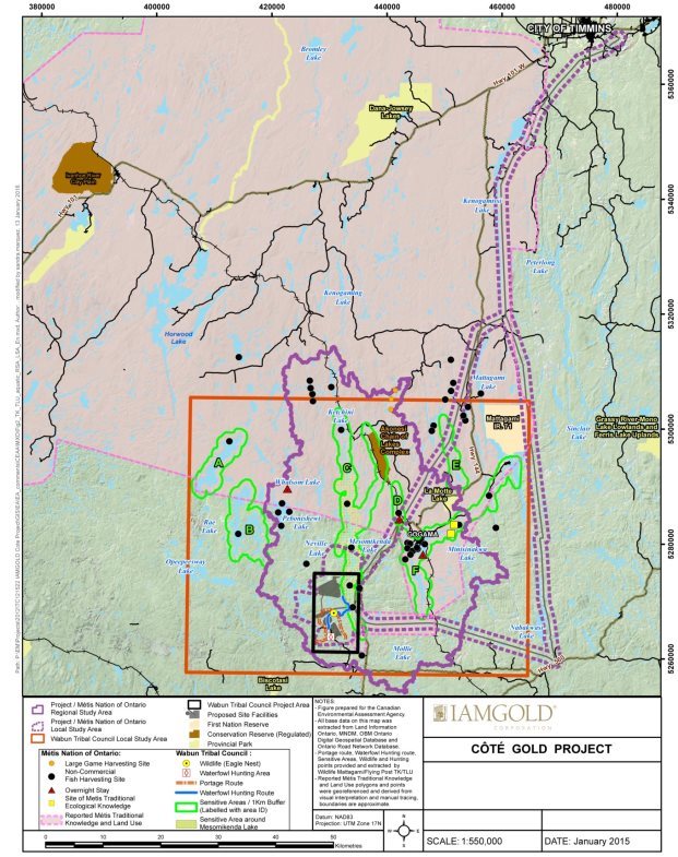
Source: IAMGOLD Corporation, January 2016.
Figure 7-2: Overview of traditional knowledge and traditional land use in the regional and local terrestrial biology study areas

Source: IAMGOLD Corporation, January 2016.
Proposed mitigation measures, monitoring and follow-up
The proponent has committed to implementing mitigation measures, monitoring and follow-up related to effects on the current use of lands and resources for traditional purposes. The proponent has also committed to a number of measures to mitigate effects on water quantity (Section 6.1), water quality (Section 6.2), atmospheric environment (Section 6.3), terrestrial landscape (Section 6.4), fish and fish habitat (Section 7.1) and migratory birds (Section 7.2). Many of these commitments will also serve to mitigate effects to the current use of lands and resources for traditional purposes by reducing the extent of changes to the environment. Measures are listed in Appendix F and include:
- Use mechanical means to avoid the use of chemical agents for vegetation clearing along the transmission line right-of-way.
- Retain existing low-lying vegetation along the transmission line right-of-way thereby minimizing vegetation clearing and allowing for the maintenance of root masses and ground vegetation that will reduce the potential for erosion and encourage continued vegetation growth. Also implement further mitigation measures to progressively revegetate and rehabilitate habitats, and time vegetation removal as described in Sections 7.2 and 8.1 respectively.
- Rehabilitate the project site to support habitats for plants and wildlife.
- Create topsoil and overburden stockpiles for use in future rehabilitation activities, clean construction equipment and vehicles on a regular basis to limit or prevent the transfer of invasive plant species from equipment and imported soil used for rehabilitation, and use locally-sourced native species to revegetate disturbed and exposed areas.
- Use existing roads and trails to minimize the construction of new roads.
- Enforce speed limits on project roads.
- Prohibit project personnel, who are working or residing on-site, from hunting and fishing in the area.
- Establish suitable portage connections and canoe route alternatives to facilitate navigation and ensure travel routes remain usable during the construction and operation phases of the Project. The proponent commits to engage users to identify suitable alternative canoe and portage routes, and conditions for crossing lakes where controlled or limited access may be required.
The proponent is committed to the following monitoring and follow-up activities related to current use of lands and resources for traditional purposes:
- Monitor wildlife presence at the project site.
- Engage with Aboriginal groups about potential effects on traditional activities throughout the life of the Project.
- Establish a traditional land use monitoring program, in consultation with Aboriginal groups, as appropriate. Should additional information about traditional land and resource uses become available, review and consider any potential effects, and develop and implement necessary mitigation measures, as appropriate. Details will be determined and documented as part of a socio-economic community management plan.
Predicted residual effects
After mitigation measures are applied, the proponent predicts residual effects on the current use of land and resources for traditional purposes to be moderate in magnitude as the Project overlaps with some sites and areas used for traditional plant harvesting, hunting and trapping, fishing and navigational routes (i.e. canoe, portage and camping) but will not limit the overall ability to continue these traditional activities. A waterfowl hunting site and route are predicted to be lost.
Parts of the Project will overlap with some traditional plant harvesting areas; however, the proponent does not expect that impacts on traditional plant harvesting will affect the ability to harvest plants in the local or regional study areas. In addition, some of the plants described as being important for traditional use may increase in abundance along the transmission line alignment due to increased light levels.
Parts of the Project will overlap with traditional hunting areas but the proponent has predicted no measurable changes to population levels for wildlife species identified as being of importance for traditional hunting and trapping in the terrestrial biology local or regional study areas.
The Project may affect a small number of water bodies, though none of these water bodies have been identified as used for traditional fishing. The transmission line alignment will overlap areas described as being of importance for traditional fishing; however, this will not impede the ability to fish in areas described as being of importance for traditional fishing activities.
Access to the traditional and 4M Circle Canoe routes will be affected during the construction phase while realignment and retention dams are constructed. Controls to access will continue to be in place during the operation phase; however, the proponent does not predict this to limit the ability to navigate through the area. As a health precaution, navigation through areas where air quality exceedances may occur will be limited to 24-hours or less and four campsites will be removed. In addition, some users may avoid the traditional and 4M Circle Canoe routes due to the aesthetic changes to the landscape caused by the mine rock area and tailings management facility.
The proponent predicts the geographic extent of residual effects to be restricted to the project footprint for traditional plant harvesting, and extend into the biological and aquatic local study areas for traditional hunting, trapping, fishing and navigational routes. Residual effects are predicted to be high in duration (beyond 15 years) for traditional plant harvesting, hunting, trapping, fishing and navigational routes. Frequent or continuous residual effects have been predicted on all of these traditional land and resource uses. Residual effects on traditional hunting, trapping, and travel routes are predicted by the proponent to be partially reversible. Residual effects on traditional plant harvesting and fishing are predicted by the proponent to be fully reversible with no additional residual effects predicted to occur at the end of the decommissioning phase.
7.3.2 Views expressed
Aboriginal groups
The Wabun Tribal Council, on behalf of the Mattagami First Nation and the Flying Post First Nation, expressed a number of concerns related to the current use of lands and resources for traditional purposes which are presented in Appendix E. In particular, the Wabun Tribal Council noted that the proponent's effects analysis for current use of lands and resources for traditional purposes was oversimplified, that the new portion of the transmission line alignment will result in habitat fragmentation and provide increased hunter access and competition for resources , and that the proponent's Environmental Impact Statement provides little evidence to support the proponent's conclusion that impacts to lands and resources can be remediated to a quality comparable to conditions before the Project. The proponent is of the view that the effects analysis adequately incorporates the information available on current use of lands and resources for traditional purposes. The proponent acknowledged that the transmission line alignment will result in habitat fragmentation and identified that access along the existing part of the transmission line alignment already exists. The proponent also committed to monitor the success of revegetation plans during decommissioning and to engage Aboriginal groups to achieve the goals of closing the site as required by Ontario's Mining Act. Wabun Tribal Council's concerns are discussed further in the Agency analysis (Subsection 7.3.3).
The Métis Nation of Ontario expressed a number of concerns about the current use of lands and resources for traditional purposes which are presented in Appendix E. In particular, the Métis Nation of Ontario wanted to ensure that the results of its traditional knowledge and traditional land use study were considered and mitigation measures, including accommodation for impacts, identified. The Métis Nation of Ontario also expressed concern about direct loss of or restriction of access to quality sites and impacts on traditional plants and wildlife species. They commented that there could be changes to known wildlife movements and behavioural patterns. The proponent is of the view, upon review of the Métis Nation of Ontario traditional knowledge and traditional land use study, that significant adverse effects on Métis current use of lands and resources are not predicted. The proponent also noted that effects on seasonal wildlife movements and behaviours were considered and no significant effects found.
Both the Wabun Tribal Council and the Métis Nation of Ontario noted that given the uncertainty on the anticipated timeline for project construction, there is a high potential for changes to occur to environmental baseline conditions, which could invalidate the predictions of the environmental assessment. As an example, the Wabun Tribal Council reported that as the quality of the forest improves following past logging, traditional land uses that previously occurred more extensively in the area are anticipated to increase. Wabun Tribal Council also noted that Aboriginal trapping was extensive in the area prior to the transfer of traplines to non-Aboriginal persons and the advent of modern industrial logging over the past 30 years. The proponent is of the view that changes to the baseline environment are unlikely in the absence of any mining activity. The proponent has committed to continuing to monitor various aspects of the environment between completion of the environmental assessment and commencement of the Project and to use this information to support future permitting processes and environmental management plans.
7.3.3 Agency analysis and conclusion
Analysis of the effects
The Agency has considered the information provided by the proponent and Aboriginal groups in its analysis of the effects on current use of lands and resources for traditional purposes. The proponent did not include details from the traditional knowledge and land use study prepared by the Métis Nation of Ontario in its effects analysis due to the timing of its submission. Upon receipt of the study, the proponent reviewed the information provided and determined that no changes were required to the conclusions of its effects analysis. The Agency has considered all information received from the Métis Nation of Ontario in reaching its conclusions.
Effects on access
The Project will result in the loss of areas used for traditional practices, such as a traditional waterfowl hunting site and route, due to project infrastructure within the project footprint. In addition, access within the future property boundary will require the permission of the proponent. Traditional activities within that boundary may be limited for health and safety reasons. The geographic extent of the property boundary is still being finalized; however, the Agency assumes it may extend beyond the project footprint to include areas between and around each project component, and will likely be informed by modelled air quality exceedances to satisfy Province of Ontario legislative requirements. To better understand the potential effects on land access, the Agency calculated the area within the modelled property extent used in the proponent's air quality models, combined with the tailings management facility. The calculated area encompasses approximately 4000 ha; however, the actual potential property boundary is not known.
The Agency recognizes that Aboriginal people may avoid using areas in close proximity to the project footprint due to the presence of project activities or infrastructure, noise, air quality, aesthetic landscape changes, or proponent restrictions due to health and safety concerns, and security. Use of navigable canoe routes will be modified due to watercourse realignments and controlled access along portage routes. While areas used for navigation, fishing, plant gathering, hunting, and trapping activities may be affected or modified, these effects will be localized and will not limit the ability to practice these activities in the broader regional area.
Access to restricted areas will be restored during the decommissioning and abandonment phases, to the extent that it is safe and protective of human health. The Agency recognizes that habitat regeneration, including the mine rock area, tailings management facility and flooding of the open pit, will take time. Full restoration of the project footprint to a condition that replicates the pre-project environment is not possible. The Agency is of the view that measures to rehabilitate the site will mitigate the effects but acknowledges that with restored access to the project footprint, the current use of lands and resources for traditional purposes by Aboriginal groups may need to be modified or adapted to suit the regenerated environment.
The Agency acknowledges that, during the abandonment phase, many of the dams and watercourse realignments will be removed in order to allow lakes and rivers to be returned to their pre-project level and surface drainage path, where feasible. The Agency recognizes that this may have effects on land uses that develop in the new watercourse realignment areas over the life of the Project. The Agency is of the view that the effects of dismantling the dams and watercourse realignments should be taken into consideration as part of future federal and provincial decision making in relation to the Project.
Effects on resources
The Agency is of the view that changes to the abundance and distribution of plants, wildlife species and fish of importance for traditional hunting, trapping, gathering and fishing as a result of the Project are predicted to be minimal and to have a minor effect on the ability of Aboriginal peoples to carry out their traditional practices. Individual animals may be temporarily displaced as a result of sensory disturbances and will be greatest in areas adjacent to the mine site and reduced along the transmission line alignment. New roads may increase access to areas important for traditional use and may result in increased hunting pressure. While traditionally harvested plants along the transmission line alignment will be lost during the construction phase, many of the species are anticipated to naturally re-establish during the operation phase. The Agency notes that the proponent will clear vegetation using mechanical means to minimize chemicals that could affect plant quality and cause Aboriginal peoples to avoid the area. While various water bodies will be lost or affected by the mine site, these changes are not predicted to affect the availability of the fish identified as being of importance for traditional fishing based on the implementation of the key mitigation and follow-up measures identified in Section 7.1. Mitigation measures include implementing an offsetting plan for serious harm to fish which will be subject to approval by Fisheries and Oceans Canada and will involve engagement with Aboriginal groups.
The Agency notes activities and practices in the local area may need to be modified in areas adjacent to the proponent's final property boundary. The Agency considers the residual effects to be moderate in magnitude for traditional plant harvesting, hunting and trapping, fishing and navigation. Residual effects are predicted to be moderate in geographic extent extending into the local study area. Effects to traditional plant harvesting are predicted to occur continuously during the construction to decommissioning phases, while effects to traditional hunting and trapping, fishing and navigation are predicted to occur continuously during all project phases (inclusive of the abandonment phase). Effects to traditional fishing are predicted to be fully reversible with the implementation of an offsetting plan for serious harm to fish. Effects to species described as being of importance for traditional harvesting, hunting, and trapping, and effects to navigational routes are predicted to be partially reversible.
The Agency acknowledges that the proponent does not have a timeline for project construction and recognizes that land and resource use patterns can shift through time. The Agency takes into account uses actively being carried out at the time of the assessment and uses that are likely to occur in the reasonably foreseeable future provided that they have continuity with traditional practices, traditions, or customs. The Agency recommends for consideration in the Minister's Decision Statement, that the proponent's actions be informed, during all phases of the Project, by the best available information and knowledge, including community and Aboriginal traditional knowledge; that the proponent engage each Aboriginal group during all phases of the project; and that the proponent, where follow-up is required, verify the accuracy of the environmental assessment, implement any additional mitigation measures that may be required. Furthermore, the Agency has identified follow-up measures for the proponent to develop a traditional land and resource use follow-up program, prior to construction, and engage Aboriginal groups in the development and implementation of the program throughout all phases of the Project. Given these measures, the Agency notes that, should the locations and intensity of traditional practices such as hunting, trapping and plant gathering increase in the areas proposed to be affected by the Project during the time between the environmental assessment decision and project commencement, that the proponent will be informed by the best available information and will able to take measures to avoid, mitigate, or compensate for those effects. Should patterns of traditional use change, the effects of the Project are still predicted to be localized and are not anticipated to limit the ability to practice these activities in the broader regional area.
In addition, the Agency has identified key mitigation measures for the proponent to minimize effects of environmental changes caused by the Project on traditional land and resource uses; provide access to Aboriginal people to traditional areas during all phases of the Project to the extent that such access is safe and protective of health; and restore access to areas within the mine site for Aboriginal people during the decommissioning and abandonment phases, to the extent that such access is safe and protective of health; and establish suitable portage and canoe route alternatives. In many cases, the Agency has identified engagement as a requirement of a key mitigation measure. In these cases, the Agency will recommend, for consideration in the Minister's Decision Statement, that the proponent communicate with Aboriginal groups, prior to initiating that consultation, to determine the manner by which the consultation requirement would be satisfied.
The Agency will also ensure the concerns expressed by the Wabun Tribal Council and the Métis Nation of Ontario about the uncertainty with project timelines and the potential for environmental conditions to change will be shared with the appropriate federal authorities as it pertains to any future permitting processes, and with the Province of Ontario for its consideration in relation to any future provincial decisions about the disposition of Crown resources.
Key mitigation measures to avoid significant effects
The Agency has considered the mitigation measures proposed by the proponent, expert advice from federal authorities, and comments received from Aboriginal groups in recommending the following key mitigation measures (Appendix G), for inclusion in the Minister's Decision Statement:
- Minimize effects of environmental changes caused by the Project on traditional land and resource uses. Engage the Flying Post First Nation, the Mattagami First Nation, the Brunswick House First Nation, and the Métis Nation of Ontario in the implementation of measures to minimize effects on traditional land and resource uses, including:
- Progressively reclaim habitats affected by the Project at the mine site as soon as technically feasible, throughout all project phases, using native species to enhance the natural recovery of vegetation communities and minimize the introduction of invasive plant species.
- Maintain existing vegetation ground cover and avoid the use of chemical agents along the transmission line alignment.
- Provide access to traditional areas during all phases of the Project and restore access to areas within the mine site for Aboriginal people during the decommissioning and abandonment phases, to the extent that such access is safe and protective of health.
- Implement additional mitigation measures, and engage the Flying Post First Nation, the Mattagami First Nation, the Brunswick House First Nation and the Métis Nation of Ontario in doing so, should effects to traditional plant harvesting, trapping, hunting, and fishing exceed predictions.
- Establish suitable portage and canoe route alternatives for the traditional and 4M Circle Canoe routes during the construction phase, and engage Flying Post First Nation, Mattagami First Nation, Brunswick House First Nation and the Métis Nation of Ontario in doing so; verify the routes remain accessible during all phases of the Project.
Need for and Requirements of Follow-Up
The Agency has recommended the follow-up program below (Appendix G), for inclusion in the Minister's Decision Statement:
- Engage the Flying Post First Nation, the Mattagami First Nation, the Brunswick House First Nation, and the Métis Nation of Ontario in the development of a traditional land and resource use follow-up program prior to construction, and engage these Aboriginal groups in the implementation of the program throughout all phases of the Project to verify the effectiveness of measures taken to minimize effects on traditional plant harvesting, trapping, hunting, and fishing, and to verify environmental assessment predictions.
- Engage with the aforementioned Aboriginal groups on any changes to or restrictions on the current use of lands and resources for traditional purposes prior to and during the construction, operation, decommissioning and abandonment phases, and include at a minimum:
- the alternative location(s) of canoe and portage routes;
- areas where land use restrictions have been established and the nature of the restriction; and
- any additional changes or restrictions on land and resource uses in the event of an accident or malfunction.
Conclusions
Taking into account the implementation of the key mitigation measures identified in this section the Agency is of the view that the Project would not likely result in significant adverse environmental effects on the current use of lands and resources for traditional purposes by Aboriginal peoples.
7.4 Aboriginal Peoples – Health and Socio-Economic Conditions
This section describes potential adverse effects on Aboriginal health and socio-economic conditions from changes to water quality, air quality, soil quality, and from effects on fish. Assessments are based on the water quality, air quality, noise and vibration, aquatic biology and socio-economic study areas, depending on the type of effect being assessed. These study areas are described in Table 1-3 of Subsection 1.2.3.
To assess impacts on the health of Aboriginal peoples, the proponent undertook a human health risk assessment which considered pathways through which health may be affected by changes to water, air, and soil quality. These pathways include drinking water, skin contact with water, consumption of fish that may contain increased methylmercury levels, breathing air at and near the mine site, and consumption of traditional plants. To assess impacts on Aboriginal socio-economic conditions, the proponent considered the input from Aboriginal groups identified through consultations.
7.4.1 Proponent's assessment of environmental effects
Anticipated effects on Aboriginal health related to drinking water and skin contact with water
As discussed in Subsection 6.2.1, water quality may be affected by leaching of metals and ions from stockpiles of mine rock, seepage losses, and discharge of effluent into the environment, among other sources. The mine water (contact water and seepage) would be collected and recycled, and effluent would be treated prior to being discharged into the environment. At times when effluent is discharged during the operation phase, the proponent indicated that arsenic may exceed the Guidelines for Canadian Drinking Water Quality, and that antimony may exceed the Guidelines for Canadian Drinking Water Quality and the Ontario Drinking Water Standards within the initial effluent mixing zone at the lower basin of Neville Lake. The initial effluent mixing zone is not considered a drinking water source, and the proponent anticipates that these exceedances would be infrequent and localized to the initial effluent mixing zone. Therefore, the proponent does not anticipate Aboriginal peoples would consume contaminated water within the initial effluent mixing zone and does not expect impacts to the health of Aboriginal peoples from drinking water or skin contact with water.
Anticipated effects on Aboriginal health related to consumption of fish
As discussed in Subsection 6.1.1, realignments of the Mollie River and Bagsverd Creek will result in flooding in Bagsverd Lake South and Chester Lake. In Bagsverd Lake South, vegetation decay as a result of this flooding may lead to methylmercury production, as described in Subsection 6.4.1. However, no direct harm to fish is predicted due to increased methylmercury (Subsection 7.1.1), and the proponent does not predict changes to existing Province of Ontario restrictions on human consumption of fish in water bodies near the Project.
Anticipated effects on Aboriginal health related to breathing air
As discussed in Subsection 6.3.1, air quality may be affected by emissions of dust and contaminants from blasting, drilling, vehicles, ore processing and other activities at the proposed mine site. The proponent predicts that exceedances of the Province of Ontario's Ambient Air Quality Criteria or the Canadian Ambient Air Quality Standards would occur at and near the mine site, over some portions of Three Duck Lakes, and beyond the proposed property boundary, particularly to the north and east. These exceedances would occur within the air quality local study area for 1-hour average concentrations of nitrogen dioxide, and 24-hour average concentrations of total suspended particulates, particulate matter (PM10) and fine particulate matter (PM2.5). The maximum 24-hour average concentrations of hydrogen cyanide are predicted to approach Ontario's Ambient Air Quality Criteria at the proposed property boundary, and could exceed them inside the proposed property boundary.
As described in Subsection 7.3.1, traditional land uses and activities including plant harvesting, hunting, trapping, fishing, navigation along traditional routes (i.e. traditional and 4M Circle Canoe routes) and camping, are occurring near the mine site and within the proposed property boundary where there may be exceedances of air quality criteria. To minimize the frequency and duration of exposure to airborne contaminants, and limit potential health risks for Aboriginal peoples, the proponent will control access by limiting stays to 24 hours or less. Appropriate signage will be placed at those areas to notify users. Short-term access to areas within the property boundary will be allowed only for specific activities, with permission from the proponent. Navigation has been identified by the proponent as a permissible activity. Access to lakes, as described in Subsection 7.3.1, will be controlled but will remain open to navigation, including use of these lakes as part of the 4M Circle Canoe Route. To prevent prolonged exposure to air contaminants, no long-term camps or stays will be permitted, and existing campsites will be removed in areas where exceedances of air quality criteria or guidelines are anticipated.
The proponent noted that its air quality model is conservative, that these modelled exceedances would occur infrequently (up to five percent of the year), and would be localized in areas immediately near the mine site. As a result of this, along with the consideration of restricting access to these areas to less than 24 hours, the proponent anticipates no adverse effects on Aboriginal health from exposure to air at or near the mine site.
Anticipated effects on Aboriginal health related to consumption of traditional plants
As noted in Subsection 6.3.1, the proponent modelled deposition of dust rates on soils in plant harvesting areas, and determined that maximum dust deposition rates of approximately 40 grams per square metre per year would occur along the 4M Circle Canoe Route near Middle Three Duck Lakes. It does not predict any appreciable changes to soil quality resulting from the deposition of dust and airborne contaminants, including metals, on soils that may then be available for uptake by traditional plants. The proponent indicated that this is the primary pathway from which effects due to dust deposition would occur, and undertook no further analysis of contamination to traditional plants. The proponent does not anticipate adverse effects on Aboriginal health from the consumption of traditional plants, including those harvested within the extent of air emission exceedances. Based on this conclusion, the proponent also did not identify any residual effects on Aboriginal health related to the consumption of traditional plants.
Anticipated effects on Aboriginal socio-economic conditions
No Aboriginal businesses or commercial activities were identified while the proponent completed its impact assessment. Aboriginal groups provided information to the proponent describing socio-economic interests after the impact assessment was completed. The proponent determined, based on its review of this information, that there were no changes to its conclusion that adverse effects on Aboriginal socio-economic conditions were not predicted. Based on this conclusion, the proponent also did not identify any residual adverse effects on Aboriginal socio-economic conditions.
Proposed mitigation measures, monitoring and follow-up
The proponent has proposed several measures to reduce effects related to changes to air quality, water quality, water quantity, and terrestrial landscape, and effects to fish. Many of these measures have been described in Chapter 6 and Section 7.1. A full listing of the proponent's proposed mitigation measures and monitoring plans is provided in Appendix F and includes:
- Control access in areas (i.e. land and water bodies) where exposure to air with potential exceedances of Ontario's Ambient Air Quality Criteria or the Canadian Ambient Air Quality Standards may occur. This may include removing campsites in areas where these exceedances may potentially occur.
- Remove terrestrial vegetation and organic soils around Bagsverd Lake South prior to flooding to mitigate the potential for methylmercury production.
The proponent has proposed several monitoring and follow-up activities to verify mitigation measures and to validate predictions related to changes to air quality, water quality, water quantity, and terrestrial landscape, and effects to fish. Many of these monitoring activities have been described in Chapter 6 and Section 7.1. A full listing of the proponent's proposed monitoring and follow-up activities is provided in Appendix F and includes:
- Monitor fish tissue for total mercury in areas affected by water body realignments (as discussed in Appendix C) and in reference areas (Schist Lake, shown in Section 2.2, Figure 2-2), every three years during the operation phase and twice following the decommissioning phase or until mercury concentrations in fish are stable or equal to reference areas.
The proponent is also committed to the following monitoring and follow-up activities related to Aboriginal socio-economic conditions:
- Develop a socio-economic community management plan to monitor and respond to project effects on socio-economic conditions.
Predicted residual effects
After mitigation, the proponent considered residual effects on water quality to be above baseline concentrations but less than the applicable water quality guidelines (moderate in magnitude) with localized exceedances of drinking water guidelines and criteria within approximately 20 m of the initial effluent mixing zone, where surface water is not likely consumed. Effects are predicted to extend into the water quality local study area (moderate in geographic extent), during the operation phase for up to 15 years (moderate in duration). Effects are predicted to occur intermittently as effluent discharge will only occur periodically (moderate in frequency). Effects are predicted to be fully reversible.
After mitigation, the proponent considered residual effects on Aboriginal health from consumption of fish with increased methylmercury levels. Methylmercury levels in fish are not predicted to change in a measurable way or require additional restrictions on human consumption (low in magnitude). Effects would extend into the aquatic biology local study area (moderate in geographic extent), and would occur from the construction phase until the filling of the open pit during stage 1 of the abandonment phase (high in duration). The residual effects would occur continuously (high in frequency) and would be partially reversible, as available vegetation in Bagsverd Lake South would eventually decay completely, which would halt the production of methylmercury.
After mitigation, the proponent considered residual effects on Aboriginal health from exposure to air contaminants. The proponent anticipates that 1-hour average concentrations of nitrogen dioxide may exceed Ontario's Ambient Air Quality Criteria in areas where traditional land uses and activities have been identified (high in magnitude). While 24-hour average concentrations of total suspended particulates, particulate matter (PM10), fine particulate matter (PM2.5) and hydrogen cyanide may exceed Ontario's Ambient Air Quality Criteria or the Canadian Ambient Air Quality Standards in these same areas, the proponent's access control measures would limit exposure to these air contaminants to less than 24 hours (moderate in magnitude). Residual effects would extend beyond the proposed mine site but be within the air quality local study area (moderate in geographic extent), and would occur during the construction and operation phases (high in duration). These exceedances to baseline levels would occur continuously (high in frequency) and would be fully reversible.
7.4.2 Views expressed
Government authorities
Health Canada requested that the proponent consider potential additive effects of exposure from multiple chemicals of concern. The proponent acknowledged that there may be a risk of underestimating the combined effects of chemicals of concern on a specific organ, and that any additive effects of compounds that operate on multiple organs are difficult to evaluate with any degree of certainty. The proponent recognized that some air contaminants, such as particulate matter and nitrogen oxides, may interact, but is of the view that provincial and federal exposure limits already reflect combined exposure to multiple contaminants. The proponent is also of the view that other chemicals of concern are not predicted to be present at concentrations that would cause a risk to health. Health Canada is not satisfied with this response, and requested that the proponent consider the additive effects of chemicals of concern, to ensure that health effects are not underestimated. This issue is discussed further in the Agency analysis (Subsection 7.4.3).
Health Canada commented that health effects of fine particulate matter (PM2.5) and particulate matter (PM10) may occur at any level of exposure, and that the risks associated with exposure to fine particulate matter (PM2.5) are higher than the health risks associated with particulate matter (PM10) or total suspended particulates. Health Canada also noted that mitigation measures to protect human health should consider reducing human exposure to dust and airborne contaminants. The proponent is committed to restricting access in areas within the property boundary to short periods of time, to limit exposure to dust and airborne contaminants. The proponent does not expect health effects related to changes in air quality.
Health Canada commented that metal concentrations in soil can be used as an indicator for metal concentrations in edible vegetation. Health Canada advised that should an increase in the concentration of metals in the soil from baseline conditions be observed, the risk assessment should be revisited to determine the potential health effects. The proponent is of the view that the depositional model for air pollutants did not show considerable changes in soil quality. Therefore, the proponent does not expect health risks associated with consumption of contaminated traditional plants. Health Canada indicated it is not satisfied with the proponent's response, and requested the proponent monitor these plants in the areas where it remains accessible. This issue is discussed further in the Agency analysis (Subsection 7.4.3).
Environment and Climate Change Canada commented that there is uncertainty with the proponent's conclusion that water level changes in Chester Lake will not cause methylmercury production. Environment and Climate Change Canada identified that once methylation of mercury has occurred and is detected within fish tissue it may be too late to implement mitigation to prevent further methylation. However, it also recognized that the most effective mitigation strategies require a balance between methylation prevention and other adverse effects to water quality and habitat from unnecessary removal of vegetation and organic soils. The proponent anticipates that methylmercury production in Chester Lake is not likely to occur as project activities are predicted to result in water level changes within seasonal ranges for the lake. For Bagsverd Lake South, the proponent commits to removing terrestrial vegetation and organic soil where flooding would occur to limit the conditions favourable for methylmercury production. This topic is discussed further in the Agency analysis (Subsection 7.4.3).
The Sudbury and District Health Unit of the Ontario Ministry of Health and Long-Term Care, noted that soils native to the area are typically heavily mineralized, and questioned whether general Ontario soils were a reasonable baseline comparison for future deposition on soils. The proponent undertook a model of soil depositions and indicated that background concentrations of elements in the soil are within the range considered for background for general Ontario soils. The Sudbury and District Health Unit is satisfied with the proponent's response.
Aboriginal groups
The Wabun Tribal Council provided similar comments to those of Health Canada about potential additive and cumulative effects of exposure to multiple chemicals of concern. The Wabun Tribal Council is satisfied with the proponent's response.
The Wabun Tribal Council indicated that the proponent should assess potential risks to waterbirds and shorebirds resulting from exposure to tailings at the tailings management facility, and determine any related potential impacts on the health of Aboriginal peoples from consuming waterbirds and shorebirds that have come in contact with tailings. The proponent is of the view that waterbirds and shorebirds would not consider the tailings management facility to be suitable habitat and were unlikely to use the tailings management facility, and therefore did not evaluate these potential health risks. The Wabun Tribal Council disagreed with the proponent's view, and believes that tailings beaches with standing water may be attractive to shorebirds and waterbirds. As a result, the Wabun Tribal Council requested that the proponent validate its view by monitoring for the presence of shorebirds and waterbirds.
The Brunswick House First Nation indicated the importance of considering the quality of water systems, plants, and soils, and indicated that they were satisfied with the proponent's mitigation measures.
The Métis Nation of Ontario expressed concerns about the potential use of herbicides along the transmission line right-of-way impacting plants traditionally harvested. The proponent committed to avoiding the use of herbicides along the transmission line right-of-way. As a result there are no predicted effects on Aboriginal health from the use of herbicides.
The Wabun Tribal Council identified that the scope of the socio-economic information presented in the proponent's Environmental Impact Statement was limited. As such, the Wabun Tribal Council requested involvement in the collection of information for use in the socio-economic impact assessment. The proponent indicated that it made reasonable efforts to obtain this information from the Wabun Tribal Council, and that the socio-economic assessment method applied best practices. The proponent also committed to continue working with potentially affected Aboriginal groups on impacts on Aboriginal socio-economic conditions related to the Project.
The Métis Nation of Ontario identified in the traditional knowledge and traditional land use study that the potential loss of access resulting from the Project to specific harvesting areas, may result in a loss of income for any individuals working in the outfitting industry. The Métis Nation of Ontario also expressed concerns that such socio-economic information within the traditional knowledge and traditional land use study, provided after the proponent completed its impact assessment, was not considered. The proponent noted that no Aboriginal businesses or commercial activities were identified through the impact assessment. The proponent also indicated that it reviewed the information and that no changes were required to its conclusion that adverse effects on Aboriginal socio-economic conditions were not predicted.
Both the Wabun Tribal Council and the Métis Nation of Ontario noted that given the uncertainty on the anticipated timeline for project construction, there is a high potential for changes to occur to socio-economic baseline conditions, which could invalidate the predictions of the environmental assessment. This is discussed further in subsection 7.4.3.
7.4.3 Agency analysis and conclusion
Analysis of the effects – health of Aboriginal peoples
With respect to health effects associated with ingestion or dermal contact with contaminants in water, some exceedances of baseline levels have been predicted, but these levels are predicted to be below applicable federal and provincial guidelines. The Agency notes, the proponent predicts effects from effluent discharges into Neville Lake, at the outflow of Bagsverd Creek, to result in localized exceedances of the Guidelines for Canadian Drinking Water Quality and the Ontario Drinking Water Standards. This effect is predicted to occur periodically during the operation phase, and would be fully reversible. The Agency recognizes the proponent's commitment to treat process water in a manner that removes cyanide prior to discharge to the tailings management facility, implement measures to limit seepage losses, and collect seepage and contact water in a manner that will prevent the release of untreated effluent into the environment. The Agency also notes that while water in or near the initial effluent mixing zone has not been explicitly identified as a source of drinking water for Aboriginal people, Neville Lake is within an area where known traditional land use occurs (i.e. Sensitive Area C), as identified by Wabun Tribal Council and in areas of reported Métis traditional knowledge and land use (Section 7.3). To further address potential health risks to Aboriginal peoples, the Agency recommends, for consideration in the Minister's Decision Statement, that the proponent engage and notify Aboriginal groups as soon as possible of the locations where effluent discharge would occur, and to determine the best ways to notify them when those periodic discharges would occur.
The Agency acknowledges Environment and Climate Change Canada's concern related to the potential for methylmercury production in Chester Lake and notes the proponent's prediction that favourable conditions for methylmercury production will not be present. The Agency notes the Province of Ontario identified concerns about the elevated levels of mercury in fish tissue in Chester Lake and the potential effects this may have once Chester Lake surface water is re-directed to flow into Clam Lake, and may require additional monitoring of mercury in water and fish tissue. The Agency has identified, as a key mitigation measure, that the proponent implement measures prior to construction to avoid methylmercury production in Bagsverd Lake South. The Agency has also identified follow-up measures for the proponent to monitor methylmercury concentrations in surface water and fish tissue in all water bodies with predicted water level increases, and in downstream water bodies, to confirm that methylmercury levels do not increase.
The Agency is of the view that the Project could pose potential risks to Aboriginal health due to exceedances of 1-hour limits and 24-hour limits of Ontario's Ambient Air Quality Criteria or the Canadian Ambient Air Quality Standards in areas at and near the mine site where navigation and other current use of lands and resources for traditional purposes occur. The proponent noted that these modelled exceedances would be infrequent (i.e. up to five percent of the year over some parts of the canoe route), that their model is conservative, and would likely over-predict emissions of air contaminants. The Agency acknowledges that the proponent will implement measures to minimize emissions of fugitive dust and air contaminants from Project activities. As described in Section 7.3, the Agency has identified key mitigation measures for the proponent to provide access to traditional areas during all phases of the Project, to the extent that such access is safe and protective of health.
Since controlled access will be allowed within the proposed property boundary, the Agency has identified key mitigation measures for the proponent to regularly communicate with Aboriginal groups the frequency of exceedances of 1-hour limits and 24-hour limits of air quality criteria in areas at and near the mine site where there may be traditional land use. The Agency has also identified key mitigation measures for the proponent to regularly communicate with Aboriginal groups of potential health and safety risks associated with exposure to air contaminants at the levels that are measured in these areas. Furthermore, the Agency has identified follow-up measures for the proponent to monitor components that have been identified as likely to exceed 1-hour limits or 24-hour limits of Ontario Ambient Air Quality Criteria or the Canadian Ambient Air Quality Standards in areas of traditional use near the mine site and within the proposed property boundary, including total suspended particulates, particulate matter (PM10), fine particulate matter (PM2.5), nitrogen oxides, and hydrogen cyanide. This monitoring would occur, at a minimum, at locations where the highest concentrations of these contaminants are expected within areas where navigation and other current use of lands and resources for traditional purposes occur. This monitoring would be frequent enough to understand and predict temporal trends in air quality concentrations in relation to 1-hour and 24-hour limits of Ontario Ambient Air Quality Criteria and the Canadian Ambient Air Quality Standards, so that as the Project continues, the proponent can regularly communicate to Aboriginal groups about potential anticipated health and safety risks in a proactive manner, while minimizing corollary effects on traditional uses that may be caused by a perception of risk at times that are not necessary.
The Agency notes that the proponent does not anticipate changes to soil quality from deposition of dust and airborne contaminants. The Agency also notes that the proponent did not undertake further analysis of other pathways of potential contamination of traditional plants, such as potential contaminants directly being deposited on traditional plants. The Agency is of the opinion that adverse effects to country foods may occur (Appendix B) and acknowledges the proponent's commitment to monitor dust deposition through appropriately located dust fall jars, while noting that the accumulation of dust in the soil over time can also be a concern. The Agency has identified follow-up measures for the proponent to monitor dust deposition to validate their prediction of maximum dust deposition rates of approximately 40 grams per square metre per year in areas where traditional harvesting would occur. If this dust deposition rate is exceeded, the Agency has identified key mitigation and follow-up for the proponent to evaluate potential risks from the consumption of traditional plants, notify Aboriginal groups of the potential health risks, and implement further measures to mitigate risks to human health. The Agency has also identified follow-up measures for the proponent to notify Aboriginal groups of any potential human health risks associated with the Project. The Agency is of the opinion that implementation of measures to minimize dust emissions will limit associated health risks from consumption of traditional plants.
As noted in Section 7.3, the Agency has identified follow-up measures for the proponent to verify the environmental assessment predictions in relation to traditional land and resource use including any shifts in land use patterns overtime. Through these provisions, the Agency expects that the proponent would adapt the locations of air quality monitoring accordingly.
In addition, the Agency notes the Wabun Tribal Council's concern about consuming wildlife, such as waterbirds and shorebirds, that may have come into contact with contaminated water in the tailings management facility and polishing pond. The Agency notes that the proponent does not expect the tailings management facility would serve as suitable habitat for waterbirds and shorebirds. The Agency has identified key mitigation for the proponent to deter ungulates and birds from frequenting these areas and engaging Aboriginal groups to develop triggers and thresholds for the program.
Analysis of the effects – Aboriginal socio-economic conditions
The Agency notes that the proponent does not anticipate adverse environmental effects to Aboriginal socio-economic conditions, and did not undertake further analysis of potential effects. The proponent did, however, assess effects on recreational and commercial fishing, cottages, and outfitters as part of its land use indicators. The Agency's assessment of potential effects on Aboriginal socio-economic conditions considered these predicted environmental effects (Appendix B). The Agency also considered potential effects to commercial plant harvesting and campgrounds.
Métis Nation of Ontario expressed interest in effects particularly in relation to commercial plant harvesting, although no specific commercial sites were identified. The Agency is of the view that there will be no measurable effect on plant abundance and distribution for harvesting purposes on a local and regional scale (Section 7.3).
The Agency notes that no Aboriginal baitfish harvesting sites were identified within the socio-economic aquatic biology local study area; however, sites within the aquatic biology regional study area were identified by the Métis Nation of Ontario. The Ontario Ministry of Natural Resources and Forestry advised that although there may be loss of baitfish harvesting for some licence holders, there are many opportunities for baitfish harvesting within the region to continue. As a result, the Agency is of the view that no significant effects on baitfish harvesting are likely to occur.
The Agency notes that no Aboriginal cottages, outfitters, or commercial and recreational interests that may be affected were identified. Potential negative affects to campgrounds have not been predicted.
The Agency acknowledges that the proponent does not have a timeline for project construction. The Agency also recognizes that socio-economic conditions can shift through time. The Agency recommends, for consideration in the Minister's Decision Statement, that the proponent use best available information and knowledge, including community and Aboriginal traditional knowledge, throughout all phases of the Project. The Agency recommends, for consideration in the Minister's Decision Statement, that the proponent engage Aboriginal groups so that the groups have opportunities to provide the proponent with up-to-date information on a continuous basis throughout all phases of the Project. Consequently, the ongoing participation by Aboriginal groups in the proponent's engagement activities will support collaboration.
The Agency is of the opinion that mitigation and follow-up measures designed to address environmental changes caused by the Project on the current use of lands and resources for traditional purposes will also serve to address potential adverse effects to resources important for Aboriginal socio-economic purposes. As such, no additional key mitigation or follow-up measures have been proposed concerning socio-economic conditions. Furthermore, the Agency acknowledges the proponent has committed to work with Aboriginal groups to develop and implement a socio-economic effects management plan. Since the Agency recommends, for consideration in the Minister's Decision Statement, that the proponent use best available information and knowledge, it can be reasonably expected that the activities of the proponent will be informed by the updated information provided by Aboriginal groups.
Key mitigation measures to avoid significant effects
The Agency has considered the mitigation measures proposed by the proponent, expert advice from federal authorities and comments received from Aboriginal groups in recommending the following key mitigation measures (Appendix G), for inclusion in the Minister's Decision Statement:
- Mitigation for effects on Aboriginal health related to water quality
- Implement measures prior to construction to avoid methylmercury production in Bagsverd Lake South.
- Prior to construction, engage with the Flying Post First Nation, the Mattagami First Nation, the Brunswick House First Nation and the Métis Nation of Ontario, to identify performance-based measures to deter ungulates and birds that are of importance to traditional diets from frequenting the tailings management facility and polishing pond; develop triggers and thresholds for the implementation of those measures; and, implement those measures during the operation and decommissioning phases should these species be found frequenting the tailings management facility and polishing pond.
- Mitigation for effects on Aboriginal health related to air quality
- Implement best measures to minimize emissions of fugitive dust and airborne contaminants during all phases of the Project.
- Minimize potential hydrogen cyanide emissions at the tailings management facility by treating process water such that cyanide is destroyed prior to discharge into the tailings management facility.
- Communicate to Aboriginal peoples the potential health and safety risks of accessing areas within the proposed property boundary, particularly in areas where 1-hour or 24-hour limits of Ontario's Ambient Air Quality Criteria or Canadian Ambient Air Quality Standards are exceeded, or are likely to be exceeded. Communicate the frequency of exceedances of 1-hour limits and 24-hour limits of Ontario's Ambient Air Quality Criteria or Canadian Ambient Air Quality Standards, to facilitate access to traditional areas during all phases of the Project, while maintaining health and safety.
- Should dust deposition rates be found to exceed 40 grams per square metre per year in areas within the property boundary where traditional plant harvesting occurs:
- engage with the Flying Post First Nation, the Mattagami First Nation, the Brunswick House First Nation and the Métis Nation of Ontario;
- determine potential human health risks;
- notify these Aboriginal groups of the potential health risks; and
- implement measures to minimize the risks to human health.
Need for and requirements of follow-up
The Agency has recommended the follow-up program below (Appendix G), for inclusion in the Minister's Decision Statement:
- Monitor surface water and fish tissue every three years during the construction, operation and decommissioning phases, in and downstream of areas where increases to water levels are predicted, to confirm methylmercury levels do not increase, and once every five years after the decommissioning phase until such time as methylmercury levels have stabilized.
- Monitor for the presence of ungulates and birds of importance to traditional diets at the tailings management facility and polishing pond.
- Monitor total suspended particulates, particulate matter (PM10), fine particulate matter (PM2.5), nitrogen oxides and hydrogen cyanide, at a minimum, at locations where the highest concentrations of these contaminants are expected within areas where navigation and other current use of lands and resources for traditional purposes occur, and at a frequency that is sufficient to understand temporal trends in the concentrations of these components.
- Monitor dust deposition rates in areas within the property boundary where traditional plant harvesting occurs, to verify traditional plant resources remain safe for human consumption.
- Engage with the Flying Post First Nation, the Mattagami First Nation, the Brunswick House First Nation, and the Métis Nation of Ontario regarding any potential human health risks resulting from the Project prior to and during construction, operation, decommissioning and abandonment phases, and beyond if necessary. Notify these Aboriginal groups of:
- changes to fish consumption guidelines, such as Ontario's Guide to Eating Ontario Fish published every other year, and any major changes in consumption advice that arise between guidance publications available on Ontario's website;
- the frequency of exceedances of 1-hour limits or 24-hour limits of Ontario's Ambient Air Quality Criteria or the Canadian Ambient Air Quality Standards for total suspended particulates, particulate matter (PM10), fine particulate matter (PM2.5), nitrogen oxides and hydrogen cyanide, in areas where navigation and other current use of lands and resources for traditional purposes occur within the proposed property boundary;
- temporal trends of concentrations of air contaminants in areas where navigation and other current use of lands and resources for traditional purposes occur within the proposed property boundary, and potential health and safety risks associated with exposure to air contaminants at the levels that are measured in these areas;
- risks associated with consumption of country foods obtained within the property boundary;
- risks associated with drinking surface water at any final effluent discharge point(s); and
- any new health risks arising in the event of an accident or malfunction.
Conclusions
Taking into account the implementation of the key mitigation measures identified in this section the Agency is of the view that the Project would not likely result in significant adverse environmental effects on the health and socio-economic conditions of Aboriginal peoples.
7.5 Aboriginal Peoples – Physical or Cultural Heritage, and Effects on Historical, Archaeological, Paleontological or Architectural Sites or Structures
This section describes potential adverse effects of changes to the environment on Aboriginal physical and cultural heritage and structures, sites or things that are of historical and archaeological significance. Local and regional study areas for the assessment of potential adverse effects on Aboriginal physical and cultural heritage sites and structures of historical or archaeological importance are described in Table 1-3 of Subsection 1.2.3.
The proponent completed archaeological assessments in compliance with the terms established in the Ontario Heritage Act and in accordance with the requirements of the Ontario Ministry of Tourism, Culture and Sport. Locations in close proximity to the mine site and along the transmission line alignment were assessed including areas near the shorelines of the Mollie River, Côté Lake, Clam Lake, Little Clam Lake, Weeduck Lake, Three Duck Lakes, Chester Lake, and Bagsverd Lake. Parts of these shorelines exhibited both pre-contact and historic archaeological potential. A total of thirty-seven archaeological sites and cultural features were found and recorded, which included eighteen pre-contact archaeological sites, ten historic archaeological sites, and nine ancient trails and portages. Eight of the pre-contact sites were determined to be important and required further assessment.
In addition, twelve cultural heritage landscapes and nineteen built heritage resources were identified within the study area, and their value or interest examined in accordance with the Ontario Heritage Act. Among the cultural heritage landscapes, five are remnants of culturally modified trees that served as Aboriginal and early Euro-Canadian trail markers, and seven are remains of early trail systems or portage routes that are currently reflected in open corridors through wooded areas.
The Métis Nation of Ontario submitted a traditional knowledge and traditional land use study after the proponent submitted its Environmental Impact Statement. The information made available by the Métis Nation of Ontario was reviewed and considered by the proponent. The study describes important landscape features and historic trading or Hudson Bay Company posts within the archaeology and built heritage local study area. A burial site and formal village were also described in the archaeology and built heritage regional study area. The Métis Nation of Ontario requested the information contained in its study remain confidential.
Additional archaeological sites may be discovered during the construction phase as a result of watercourse realignments or changes to water levels that would cause some sites that are currently covered by water bodies to become exposed.
7.5.1 Proponent's assessment of environmental effects
Anticipated effects
The assessment carried out by the proponent indicates that the Project may result in effects to Aboriginal physical or cultural heritage, and effects on historical and archaeological sites or structures during the construction and operation phases. Project activities that could have the greatest effect on these sites and features are those that disturb and remove soil including site clearing, grubbing, stripping, excavation, and blasting. Construction of project infrastructure will overprint some archaeological sites. Along the transmission line alignment additional archaeological assessments will be completed in accordance with the Ontario Heritage Act when detailed designs are available.
Ontario regulations required the eighteen pre-contact and ten historic sites to be registered with the Province of Ontario. These sites are now protected under the Ontario Heritage Act and must not be disturbed until clearance is obtained from the Ontario Ministry of Tourism, Culture and Sport. Once permission is granted, Stage 3 and Stage 4 archaeological assessments may proceed for sites where impacts from project activities cannot be avoided. As a result of these protections and assessment requirements, effects are predicted to be minimal. For sites that can and have been avoided, potential adverse effects may occur as a result of erosion and secondary impacts associated with human disturbances. The Makwa Point Site (CjHI-3), Bagsverd Creek 1 Site (CjHI-27), and Table Point Site (CjHI-17) are located in close proximity to the Project and have the potential to be affected by these types of effects.
It was determined that the Project will not affect or threaten built heritage resources or cultural heritage landscapes as these features or resources are located outside of the immediate footprint of project components and are considered to be at an acceptable distance so as to not be affected. If future development is to occur in the immediate vicinity of these features or resources, then measures will be taken to avoid or protect them. Otherwise, if this is not possible, they will be thoroughly documented prior to their disturbance or removal as per regulations under the Ontario Heritage Act and guidelines from the Ontario Ministry of Tourism, Culture and Sport.
A bald eagle nest found near the mine site will need to be removed to allow for the construction of the Project. Bald eagles are of spiritual and cultural importance to Aboriginal groups in the area. The nest will be removed outside of the breeding season and it is predicted that upon the bald eagle's return to the nest site, the eagle will either find an equally suitable area to build a new nest or will take over a nearby unoccupied existing nest. The population of bald eagles in the area will not be affected by the loss of the individual nest. With the exception of the bald eagle nest, the Project does not overlap with any other known or reported cultural, spiritual or ceremonial sites of importance to Aboriginal peoples.
Proposed Mitigation Measures, Monitoring and Follow-up
The proponent has proposed mitigation measures to reduce effects on Aboriginal physical or cultural heritage, and effects on historical and archaeological sites or structures. These measures are listed in Appendix F and include:
- Complete additional archaeological assessment work in accordance with provincial protocols for any newly discovered sites as a result of the Project, if required.
- Avoid cultural and archaeological sites to the extent practical.
- Excavate artifacts and transfer these artifacts in accordance with provincial protocols to the appropriate Aboriginal group after the analysis work has been completed.
- Implement a 20 m no-work area and 50 m monitoring buffer during all project phases at three Aboriginal archaeological sites, the Makwa Point Site (CjHl-3), the Bagsverd Creek 1 Site (CjHI-27) and the Table Point Site (CjHl-17), to avoid site disturbance.
- Consult the Mattagami First Nation and the Flying Post First Nation prior to the removal of the bald eagle nest to help define a culturally sensitive method for the nest removal.
The proponent is committed to several monitoring and follow-up measures, which are detailed in Appendix F, to verify mitigation measures and to validate predictions during all project phases. These include:
- Monitor Makwa Point Site (CjHl-3) and Bagsverd Creek 1 Site (CjHI-27) sites during the construction to abandonment phases for potential impacts associated with erosion.
- Monitor Table Point Site (CjHl-17) during the construction to abandonment phases for potential secondary impacts such as from human disturbances related to mining activities.
- Monitor water bodies affected by lower water levels during the construction phase to identify potential newly exposed archaeological sites including monthly inspections by a licensed archaeologist or more frequently, if required.
Predicted residual effects
Aboriginal physical or cultural heritage, and effects on historical and archaeological sites or structures, affected by the Project have been assessed and excavation will follow the Ontario Heritage Act requirements and Ontario Ministry of Tourism, Culture and Sport's protocols. Sites that are predicted to be impacted by the Project or project activities will require Stage 3 and Stage 4 archaeological assessment work. Some sites will require no-work buffers and monitoring buffers to confirm they are not disturbed. Built heritage resources and cultural heritage landscapes, such as Culturally Modified Trees, that are located outside of the immediate footprint of the Project are predicted to be far enough away that no effects to these sites are predicted. After the implementation of mitigation measures, the proponent anticipates that any residual effects to sites and structures that are important to Aboriginal peoples would be low in magnitude. Residual effects would extend to the local study area (moderate in geographic extent), would occur beyond 15 years (high in duration) and would occur continuously (high in frequency). The residual effects would be irreversible for the sites that could not be avoided and have been cleared in accordance with the Ontario Heritage Act.
In terms of important cultural sites, the proponent indicated that the removal of a bald eagle nest, a culturally important species for many Aboriginal groups, would be required. Consequently, the effects during the construction and operation phases are predicted by the proponent to be low in magnitude (taking into account the removal of the eagle's nest in a culturally sensitive manner). Residual effects would extend into the local study area (moderate in geographic extent), would occur beyond 15 years (high in duration) and would occur continuously (high frequency). The proponent considers residual effects to Aboriginal cultural heritage associated with the bald eagle would be fully reversible with the implementation of Ontario's Fish and Wildlife Conservation Act legal requirements and by engaging and providing opportunities for Aboriginal groups to identify a culturally sensitive nest removal method.
7.5.2 Views expressed
Aboriginal groups
The Wabun Tribal Council and the Métis Nation of Ontario raised a number of comments about potential impacts on physical or cultural heritage, and effects on historical and archaeological sites or structures. They are presented in Appendix E. For example, the Mattagami First Nation identified the importance of having women from the community conduct water ceremonies and also asked for more information about the proponent's mitigation measure of removing the culturally important eagle's nest. The proponent indicated that as part of the archaeological assessment, aerial surveys were conducted in the vicinity of the eagle's nest and it was determined that numerous empty eagles' nests were available that could be occupied in the future, and that abundant habitat is available where new nests could be constructed. The proponent committed to remove the nest outside of the breeding season upon approval by the Ontario Ministry of Natural Resources and Forestry, consult with Aboriginal groups on how the removal can be conducted in a culturally sensitive manner, and will be open to hosting traditional, cultural and spiritual ceremonies on-site, if requested. The proponent also indicated field work to-date has involved extensive and continuous involvement of First Nation Elders and Band members to assist in the identification of areas of high archaeological potential and in testing and excavating sites. It committed to notifying Aboriginal groups of any newly discovered sites and will employ opportunities for Aboriginal group members to participate. The proponent also committed to make available the archaeological potential maps used to guide archaeological fieldwork in the local study area, redacting site location information as appropriate.
The Métis Nation of Ontario requested clarification with respect to any distinction being made between Métis and other Aboriginal archaeological sites. The proponent responded that through its archaeological assessment, of the sites that were found, none appear to relate to Métis archaeological sites and none appear to relate to the settlement of the Métis peoples.
7.5.3 Agency analysis and conclusion
Analysis of the effects
The Agency notes that the removal of some archaeological sites and a bald eagle nest would occur as a result of the Project. The Agency recognizes that the removal of the bald eagle nest and resulting disruption to the bald eagle is considered as a symbol of disrespect to Aboriginal peoples and would have a cultural and spiritual impact on the local Aboriginal groups, given the eagle's importance to their heritage. Additional effects are predicted on three pre-contact archaeological sites, in close proximity to the project footprint. Based on the Agency's review of the Métis Nation of Ontario traditional knowledge and traditional land use study and comments received, the Agency is not aware of any Métis cultural sites that will likely to be affected by the Project.
The Agency recognizes that the proponent will complete ongoing archaeological assessment work throughout the construction to abandonment phases to identify potential new archaeological sites such as sites that may be uncovered as a result of changes in water levels. The Agency notes the proponent's commitment to monitor for secondary impacts to sites, such as from human disturbances, during all project phases and expects the proponent will fulfill this commitment.
The Agency acknowledges commitments by the proponent to provide further opportunities to involve Aboriginal groups in archaeological activities should additional sites be found, and the planned involvement of Aboriginal groups in mitigating effects associated with the removal of artifacts and potential changes to sensitive sites. The Agency also acknowledges the commitment to involve Aboriginal groups in the bald eagle nest removal strategy, its openness to hosting traditional, cultural and spiritual ceremonies, and that the removal of the bald eagle nest will require approval by the Ontario Ministry of Natural Resources and Forestry. The Agency has identified key mitigation measures for the proponent to avoid and minimize disturbances to active eagle nests, and when necessary to remove the eagle nest engage with Aboriginal groups in doing so.
The Agency is of the view that these identified measures and the requirement to adhere to provincial legislation, such as the Ontario Heritage Act and Fish and Wildlife Conservation Act, will provide sufficient mitigation measures to ensure that Aboriginal physical and cultural heritage sites and structures of historical or archaeological importance are protected.
The Agency considers the residual effects to be moderate in magnitude since sites (such as the bald eagle nest) and archaeological artifacts of importance will be removed but in accordance with provincial legislative requirements and opportunities for involvement of Aboriginal groups. Residual effects are predicted to be low to moderate in geographic extent, continuous and occurring during all project phases. The adverse effects are considered partially reversible noting that efforts to recover and preserve artifacts will preserve their historical and archaeological value and efforts to remove the eagle nest in a culturally sensitive manner would not impact the overall exercise of cultural heritage practices.
Key mitigation measures to avoid significant effects
The Agency has considered the mitigation measures proposed by the proponent and comments received from Aboriginal groups in recommending the following key mitigation measures (Appendix G), for inclusion in the Minister's Decision Statement:
- Avoid, protect or recover archaeological artifacts discovered during all project phases, in accordance with the Ontario Heritage Act and associated regulations and protocols, and notify the appropriate Aboriginal groups; verify that new archaeological sites are not exposed by lower water levels in water bodies during the construction phase.
- Transfer, when appropriate and in accordance with the Ontario Heritage Act and associated regulations and protocols, archaeological artifacts to the appropriate Aboriginal groups.
- Protect existing archaeological resources from impacts such as soil erosion and human disturbances by implementing a no-work boundary consistent with the Ontario Heritage Act and associated regulations and protocols at the Makwa Point Site (CjHl-3), Bagsverd Creek 1 Site (CjHI-27), and Table Point Site (CjHl-17), during all project phases.
- Avoid and minimize disturbances to active eagle nests. Where an eagle nest must be removed to locate project infrastructure, remove the eagle's nest in accordance with Ontario's Fish and Wildlife Conservation Act and in a culturally sensitive manner, and engage with Mattagami First Nation and Flying Post First Nation in doing so.
Need for and requirements of follow-up
The Agency has not identified a need for a follow-up program with respect to physical or cultural heritage, and historical and archaeological sites or structures.
Conclusions
Taking into account the implementation of the key mitigation measures identified in this section the Agency is of the view that the Project would not likely result in significant adverse environmental effects on Aboriginal physical or cultural heritage, and historical and archaeological sites or structures.
7.6 Other Effects Related to Federal Decisions
In accordance with subsections 5(2)(a) and 5(2)(b) of CEAA 2012, the Agency considered changes to the environment, and effects of those changes (respectively), that are directly linked or necessarily incidental to federal decisions that may be required for the Project pursuant to other legislation. This included consideration of potential effects excluding those to fish and fish habitat, migratory birds, and Aboriginal peoples, which have already been addressed in Sections 7.1 to 7.5 of the Report. Federal decisions that may be required are listed in Table 1-2, Subsection 1.2.2.
To facilitate project activities (described in Section 2.3), the proponent has identified 24 water bodies for which it intends to pursue one or more decisions under the Fisheries Act, Metal Mining Effluent Regulations or Navigation Protection Act (Appendix H). The Agency has focused its assessment of effects under section 5(2) of CEAA 2012 on changes to these water bodies and associated riparian areas.
Minor changes to terrestrial habitat may also be linked to potential federal decisions. Specifically, the realignment of water channels across land, construction of new portage routes, and the facility for manufacturing and storing explosives would all cause a loss of terrestrial habitat. These losses are expected to be negligible and are not addressed further.
Additional federal decisions may be pursued by the proponent to enable additional changes to water bodies after the open pit is filled, at the beginning of the stage 2 of the abandonment phase (described further in Appendix D: and Subsection 6.1.1). At the time of this environmental assessment, the proponent cannot reasonably predict the specific federal decisions required to complete the work during the abandonment phase; therefore, the Agency completed a general assessment of effects under section 5(2) of CEAA 2012 for changes to occur after the filling of the open pit.
The loss or alteration of water bodies associated with federal decisions may cause potential adverse environmental effects on:
- Ecological components of the environment (e.g. plants, wetlands, turtles, amphibians, and other species reliant on lake and riparian habitat, including species at risk); and
- Socio-economic conditions (e.g. the navigability of lakes and a public canoe route, licensed resource users of bear management, traplines and bait harvest areas).
7.6.1 Proponent's assessment of environmental effects
Effects on ecological components of the environment
No plants with special conservation status have been reported or found in the terrestrial biology regional study area. Therefore, adverse effects to plants of special conservation status that are linked to federal decisions are not predicted and were not assessed further.
Wetlands provide habitat for amphibians, turtles, furbearers, waterfowl, and fish, and are an important contributor to natural hydrologic processes. As described in Section 6.4, approximately 177 ha of wetlands are predicted to be lost by vegetation clearing in the proposed mine site. A portion of this would be associated with the loss and alteration of water bodies that are linked to federal decisions (Appendix H). The 177 ha represents an approximate loss of eleven percent of the available wetland habitat in the terrestrial biology regional study area (see Table 1-3 and Figure 1-2 for a description of the study area). The proponent indicated that changes to the hydrologic regime in the aquatic biology local study area are not predicted to cause additional effects to wetlands and are well within the predicted adaptive capability of wetland ecosystems to be self-sustaining, provided that habitat compensation for the watercourse realignments includes the features and functions of the present watercourses. The remaining 89 percent of the wetlands in the regional study area are predicted to retain their ability to fulfill important ecosystem functions. The proponent predicts that project activities during stage 2 of the abandonment phase, such as the removal of certain dams and realignment channels after the open pit is filled, will not further disrupt wetland vegetation. Predicted changes to the terrestrial landscape including wetlands are described in greater detail in Section 6.4.
Based on reported occurrences, both Blanding's and snapping turtles may occur in the terrestrial biology local study area. These species are designated as threatened and of special concern under the Species at Risk Act, respectively. Blanding's and snapping turtles were not observed during the proponent's basking turtle surveys. Therefore, adverse effects to these species that are linked to federal decisions are not predicted and were not assessed further by the proponent.
Painted turtles were observed in water bodies that would be lost or altered in relation to potential federal decisions, including Clam Lake, Bagsverd Creek, and Unnamed Lake #2. Painted turtles have been reported in a few other locations throughout the Mattagami River watershed. Several amphibian species were recorded in the terrestrial biology local study area. Any amphibian species occurring within the terrestrial biology regional study area are expected to be common and widespread across northern Ontario. The proponent predicts that only 0.8 percent of potential painted turtle and amphibian habitat available in the terrestrial biology regional study area will be lost by construction within the mine site footprint, and that direct mortality during construction will be within the range of natural variation.
Water birds, some furbearing mammals (e.g. beavers, otters, muskrats, lynx), and moose may also be affected by the loss and alteration of water bodies associated with federal decisions (Appendix H). The proponent predicts that the Project as a whole, including a broader suite of effects than those related to federal decisions, will result in some displacement of wildlife from the mine site to suitable adjacent habitat; however this displacement is not predicted to result in measurable residual effects to wildlife populations or distribution within the terrestrial biology regional study area. Adverse effects to these species that are linked to federal decisions are predicted to be minor and have not been assessed further in this section. Effects on migratory birds and wildlife used for traditional land use are described in Sections 7.2 and 7.3.
Effects on socio-economic conditions
Navigability of canoe routes and other water bodies
Of the twenty-four water bodies that would be lost or altered in association with federal decisions, the proponent has indicated it considers eleven to be navigable or potentially navigable (Appendix H). The proponent intends to pursue approvals for potential changes to navigability on nine of these water bodies pursuant to the Navigation Protection Act. Changes (water level increases) to Chester Lake and Unnamed Lake #2 are not predicted to affect navigability.
The 4M Circle Canoe Route may be modified as a result of the construction of dams and proposed watercourse realignments. The Ontario Ministry of Natural Resources and Forestry indicated that the route has an extensive history and is easily accessible making it available to a wide range of canoeists. The proponent proposed to establish suitable portage connections and canoe route alternatives during the construction and operation phases of the Project. Section 5.2 provides additional information about the 4M Circle Canoe Route and potential effects are described in greater detail in Section 7.3.
From the proponent's project description, it is noted that other water bodies may be crossed by infrastructure that may be considered "works" under the Navigation Protection Act (e.g. access roads, transmission line, pipelines). The proponent has not indicated that federal decisions, such as the opt-in provisions described in Table 1-2 (Subsection 1.2.2), may be pursued for any of these works, therefore potential effects are not addressed in this section.
Hunting and trapping
The Ontario Ministry of Natural Resources and Forestry manages hunting and trapping activities under the authority of the Fish and Wildlife Conservation Act, 1997. The terrestrial biology regional study area is popular for hunting moose, bears, small game and upland game birds. The Province of Ontario indicated that while hunting occurs at the mine site, the site has not been identified by hunters as being a popular hunting location. Additional information about effects on traditional hunting and trapping are described in Section 7.3.
Bear management areas are parcels of Crown land that are licenced annually to tourism operators for providing black bear hunting services to non-residents. Similarly, licenced trappers are given the exclusive rights to a specific trapline area on Crown land. The proposed mine site overlaps with one bear management area and three trapline areas. Most notably, the mine site would overprint approximately eleven percent of Bear Management Area GO-31-064 and nine percent of Trapline Area GO-031. A portion of these effects to hunting and trapping include the loss and alteration of water bodies that are linked to federal decisions.
Recreational fishing and bait harvesting
The proposed mine site would affect a small number of water bodies that may be used for recreational fishing. Species typically targeted by anglers such as walleye, northern pike and lake whitefish are found in some of the water bodies listed in Appendix H, which would be lost or altered in relation to federal decisions, or for which access by canoe may be modified. Access to Mesomikenda Lake, the most popular lake used for recreational fishing in the aquatic biology regional study area, would not be affected. Additional information on effects to fish is provided in Section 7.1. Effects to recreational fishing are predicted to be similar to the effects to traditional fishing described in Section 7.3. Therefore, effects to recreational fishing are not discussed further in this section.
The Ontario Ministry of Natural Resources and Forestry manages bait harvesting under the authority of the Fish and Wildlife Conservation Act, 1997. In Ontario, bait resources (including baitfish) are assigned to commercial licence holders within specified bait harvest areas. The proponent identified four bait harvest areas that would potentially be affected by the mine site. Of these, the Agency notes that Bait Harvest Area TI-0176 and TI-0193 overlap with most of the changes to water bodies associated with federal decisions. Bait Harvest Area TI-0193 includes Côté Lake, which would be drained. Loss of bait harvest areas, and changes of access to areas, may affect bait harvesting income.
Outdoor tourism outfitters
No tourism outfitter camps are located in close proximity to the mine site footprint or would be affected by changes to water bodies linked to federal decisions. Outdoor tourism outfitters are not discussed further in this section.
Proposed mitigation, monitoring and follow-up
The proponent has proposed several mitigation measures to reduce effects to ecological components of the environment and socio-economic conditions caused by changes to the environment that can be linked to potential federal decisions. Those measures are listed in Appendix H and include:
- Limit ground clearing by minimizing the physical footprint of the mine site, as per the proposed site plan (see Figure 2-2, Subsection 1.2.3).
- Implement an offsetting plan for any serious harm to fish, and a fish habitat compensation plan using a natural channel design that mimics natural flow and flooding patterns and incorporates shoreline and riparian vegetation.
- Establish suitable portage connections and canoe route alternatives and ensure travel routes remain usable during the construction and operation phases of the Project, and engage interested portage route users in doing so.
Predicted residual effects
After mitigation measures are applied, the proponent predicts effects to wetlands will be restricted to the project footprint taking into account that habitat compensation for the watercourse realignments will include compensation for features and functions of the present watercourses. Effects to wetlands are predicted to occur throughout all phases of the Project continuously and to be partially reversible. The proponent predicts no measurable residual effect on the abundance and distribution of the painted turtle and amphibian populations.
Residual effects are not predicted to impede the use of the 4M Circle Canoe Route. It is recognized that some users may choose to avoid the route, due to its proximity to mining activities. Effects are predicted continue into abandonment phase and be fully reversible.
The proponent concluded that although the Project overlaps one bear management area and may affect a small number of water bodies used for bait harvesting, this is not predicted to limit the ability for the public to carry out hunting and bait harvesting activities in the terrestrial or aquatic local study areas. The proponent concluded that despite measures to minimize adverse effects to trapline areas (e.g. a compact project site), some loss of use and access will occur. Residual effects to hunting, trapping and bait harvesting areas are therefore predicted to be moderate in magnitude. Effects on hunting, trapping and bait harvesting are predicted to cease at some time following decommissioning. Disturbed habitats will continue to re-establish with native vegetation, and access restrictions will be removed. Effects to hunting and trapping are predicted to be partially reversible and fully reversible for bait harvesting.
7.6.2 Views expressed
Government authorities
Transport Canada requested clarification of the meaning of "suitable conditions for crossing" outlined in the proponent's mitigation measures. The proponent advised that it intends to work with potential canoe route users to identify preferred portage locations that do not interfere with project construction and operation. This could include placing markers to ensure canoes do not approach active construction sites, such as the diversion dams in Three Duck Lakes and Bagsverd Lake. Transport Canada advised that portage routes are considered part of marine navigation. If canoe or portage routes are affected by work in a waterway related to a federal decision under the Navigation Protection Act, there may be associated conditions that apply to the navigability of the portage route. Transport Canada also noted that the information provided through the environmental assessment process was not sufficient to provide accurate advice and make regulatory decisions about navigable waters; this would require a satisfactory Notice of Works.
The Ontario Ministry of Natural Resources and Forestry indicated the need for compensating non-fish species (such as amphibians, reptiles and birds) that depend on wetland features that could be destroyed. The proponent has committed to developing an offsetting plan for serious harm to fish that uses a natural channel design approach which is predicted to provide high quality habitat for both fish and non-fish species.
Aboriginal groups
The Wabun Tribal Council is of the view that the number of sampling locations for basking turtle surveys was insufficient to ensure a representative characterization of turtle populations in the area of the Project. The proponent identified that it selected sampling locations based on areas where there is a predicated potential for the habitat to be affected by the Project. The survey effort reflected the objective of the survey program which was to generate a species list for the study area, using methodology selected in consultation with the Ontario Ministry of Natural Resources and Forestry.
7.6.3 Agency analysis and conclusions
The Agency has considered the information provided by the proponent, the Province of Ontario and Aboriginal groups in its analysis of the effects of changes to the environment, and effects of those changes, that are directly linked or necessarily incidental to federal decisions. The Agency is of the opinion that adverse effects related to federal decisions on plants, amphibians, other wildlife species and outdoor tourism outfitters are all anticipated to be negligible.
The Agency acknowledges that the proponent is working to minimize its project footprint and predicts that new wetland habitat types may establish once watershed changes stabilize. The Agency is of the view that the loss of wetlands will be observable at a local scale and measurable through habitat mapping; however, the ecological effects of these losses are not likely to be detectable within the broader terrestrial biology regional study area. The Agency also acknowledges that additional effects to wetlands may occur during stage 2 of the abandonment phase when several retention dams and two channel realignments will be removed to restore certain flows and return watershed boundaries to their natural states. The Agency considers effects to wetlands to be moderate in magnitude (measurable but the changes are well within the predicted adaptive capability of wetland ecosystems to be self-sustaining), moderate in geographic extent (extending into the local study area), and occurring during all project phases continuously. These adverse effects are predicted to be partially reversible.
The Agency notes that the proponent's prediction that only 0.8 percent of painted turtle and amphibian habitat will be lost could be an underestimation, as it appears to be based on habitat calculations for beavers which include dense forest within 200 m of wetlands. The Agency is of the view that the predicted loss of eleven percent of available wetland habitat within the terrestrial biology regional study area should be considered when assessing effects on turtles and amphibians. The natural characteristics of channel design in the realignment channels may provide additional local habitat for painted turtles and amphibians. The Agency encourages the proponent to consider the implementation of site-specific mitigation measures within the realignment channels or other water bodies to enhance their suitability for painted turtles (e.g. the introduction of downed woody debris and sweeper logs, for basking, to compensate for the loss of Bagsverd Creek).
Taking into account the availability of wetland and riparian habitat in the regional study area, and that the amphibian species are predicted to be common and widespread across northern Ontario, the Agency is of the view that the proposed changes to water bodies that support painted turtles and amphibians will not likely cause a significant adverse environmental effect.
The Agency notes that the Ontario Ministry of Natural Resources and Forestry describes Blanding's turtles as being typically found throughout southern, central and eastern Ontario. Snapping turtles are described as being primarily found in southern Ontario. The Agency is aware that observations of Blanding's turtles and snapping turtles in the terrestrial biology regional study area have increased within recent years, though these species have not been observed within the proposed mine site footprint. The proponent has concluded that there will be no effects to either of these species based on lack of presence. While the Agency is of the opinion that adverse effects on Blanding's turtles or snapping turtles are not likely to occur in relation to changes to water bodies associated with federal decisions, the Agency encourages the proponent to consult the Ontario Ministry of Natural Resources and Forestry prior to construction activities to confirm the status of observed presence of Blanding's and snapping turtles in the Mollie River and Mesomikenda Lake sub-watersheds.
With respect to navigability of the 4M Circle Canoe Route and other nearby lakes, the Agency is of the view that, with the establishment of suitable portage routes and canoe route alternatives, the changes to water bodies associated with federal decisions (Appendix H) are not likely to cause significant adverse environmental effects on the navigability of the canoe route. Effects will be similar to those described in Section 7.3.
The Agency notes that changes to water bodies and realignment of watercourses that are associated with federal decisions will modify the landscape within Bear Management Area GO-31-064, Trapline Area GO-031 and two other trapline areas; however, the Agency is of the view that these changes are not the primary cause of effects (e.g. land access restrictions) to the ability to access these areas. The Agency acknowledges that licensed bait harvesters may have to modify the water bodies within which bait is harvested. The Agency is of the view that with the implementation of the mitigation and follow-up measures described in Section 7.1 bait resources will continue to be available in other water bodies.
The Agency considers effects related to federal decisions on hunting, trapping and bait harvesting to be moderate in magnitude (overlaps with bear management, trapline and bait harvest areas but does not limit ability to continue these activities), moderate in geographic extent (extending into the local study area), and occurring during all project phases continuously. The adverse effects to hunting and trapping areas are predicted to be partially reversible and fully reversible for bait harvesting.
Key mitigation measures to avoid significant effects
The Agency has not identified any key mitigation measures, for consideration in the Minister's Decision Statement, in relation to changes to the environment, and effects of those changes, that are directly linked or necessarily incidental to the federal decisions described in Appendix H.
Need for and requirements of follow-up
The Agency has not identified a need for a follow-up program with respect to changes to the environment, and effects of those changes, that are directly linked or necessarily incidental to federal decisions described in Appendix H.
Conclusions
The Agency is of the view that changes to the environment that are directly linked or necessarily incidental to federal decisions described in Appendix H, and effects of those changes, are not likely to be significant.
8 Other Effects Considered
8.1 Effects of the Project on Species at Risk
This section describes the Agency's obligation under subsection 79(2) of the Species at Risk Act to identify the Project's adverse effects on species listed in Schedule 1 of the Species at Risk Act and the critical habitat for these species. This obligation also requires the Agency to ensure measures are taken to avoid or lessen adverse effects on species at risk, and that appropriate monitoring and follow-up programs are considered if a project is carried out. The measures must be consistent with applicable recovery strategies and action plans.
The Agency has identified the following species at risk which may potentially be affected by the Project: olive-sided flycatcher, common nighthawk, eastern whip-poor-will, Canada warbler, chimney swift, barn swallow, bobolink, eastern meadowlark, rusty blackbird, short-eared owl, snapping turtle, Blanding's turtle, little brown myotis, northern myotis and tri-colored bat. The Project's effects on migratory birds that are species at risk are covered in Section 7.2, and include the olive-sided flycatcher, common nighthawk, eastern whip-poor-will, Canada warbler, chimney swift, barn swallow, bobolink and eastern meadowlark. No fish or plants identified as federal species at risk are predicted to be affected by the Project.
8.1.1 Proponent's assessment of environmental effects
Anticipated effects
This section outlines the proponent's predictions regarding species at risk in relation to the loss of habitat and habitat fragmentation, sensory disturbances (i.e. human presence, artificial light and noise), and collisions with vehicles and transmission lines. These adverse effects may result in decreased habitat quality, changes in wildlife population and abundance, changes in behaviour and movement causing individual displacement, and mortality. Table 8-1 provides a summary of predicted suitable habitat loss for the species at risk not already assessed in Sections 7.2 and 7.6.
Rusty blackbird and short-eared owl
The rusty blackbird and short-eared owl are not protected by the Migratory Birds Convention Act, 1994 but they are listed as species of concern under the federal Species at Risk Act. For the rusty blackbird, habitat loss and fragmentation from construction at the mine site and along the transmission line alignment are anticipated as a result of vegetation clearing and alteration that may cause individual displacement within the terrestrial biology local study area. For the short-eared owl, no suitable habitat is predicted to be removed as a result of the Project, and no associated effects are anticipated. Sensory disturbances from human presence, dust, artificial lights, and noise may decrease the quality of bird habitats, and alter movement and behaviour for the short-eared owl and rusty blackbird. However, these effects are predicted to be minimal and are not predicted to affect population and distribution of either species.
Snapping turtle and Blanding's turtle
Construction along the transmission line alignment is predicted to remove habitat that may be suitable for these species, but no effect to population distribution and abundance is predicted. Other potential effects to these species are assessed in Section 7.6.
Little brown myotis, northern myotis and tri-colored bat
No hibernacula such as caves, where the little brown myotis, northern myotis and the tri-colored bat can reside, were found in the project footprint. Other suitable habitat for these species, such as trees, was found in the terrestrial local study area. Habitat removal during the construction phase has the potential to change bat abundance and distribution, but the proponent expects that these local effects will have no measurable effect at the population level. Increased traffic from construction activities may lead to bat collisions with vehicles. Construction and operation of the transmission line alignment may lead to bat collisions with transmission lines, causing mortality from electrocution. Sensory disturbances may affect habitat quality and alteration, and species movement.
| Species at Risk | Suitable habitat type | Mine site | Transmission line alignment | ||
|---|---|---|---|---|---|
| Suitable habitat loss (ha) | Percent of known suitable habitat lost in local study area | Percent of known suitable habitat lost in regional study area | Suitable habitat loss (ha) | ||
| Rusty blackbird |
|
207.6 | 28.1 | 1.5 | 168.9 |
| Short-eared owl |
|
0 | 0 | 0 | 0 |
| Little brown myotis, Northern myotis and Tri-colored bat |
|
1068.7 | 14.8 | 0.4 | 130 |
Proposed Mitigation Measures, Monitoring and Follow-Up
The proponent has proposed several measures to reduce effects on species at risk. The proponent is committed to implement mitigation measures for migratory birds (Section 7.2) that would reduce the impacts of the Project on the rusty blackbird and short-eared owl.
Mitigation measures for the snapping turtle and Blanding's turtle are presented in Appendix F and include:
- Use existing infrastructure, such as roads and trails, for access to the Project and minimize construction of new roads and corridors during the decommissioning and abandonment phases to limit habitat loss and fragmentation.
- Prohibit project personnel from hunting, feeding and harassing wildlife.
- Reduce speed limits on project roads and prohibit off-road use of vehicles for recreational purposes to reduce collisions with wildlife.
Mitigation measures for bats are presented in Appendix F and include, among others:
- Avoid removing vegetation during sensitive wildlife breeding seasons.
- Minimize the width of the transmission line alignment to the proposed 50 m, to the extent practicable, to reduce effects of habitat loss and noise disturbances on bats.
- Use deterrents and deflectors on transmission lines during all project phases to reduce the risk of mortality to bats due to potential electrocution.
The proponent is committed to the monitoring and follow-up activities related to species at risk. These activities are listed in Appendix F and include:
- Monitor and maintain a registry for the presence of wildlife incidents and risks to wildlife within the project footprint through all project phases to verify the effectiveness of mitigation measures.
Predicted residual effects
After mitigation measures, the proponent anticipates there would be residual effects to species at risk from the loss of habitat and fragmentation, general sensory disturbances (i.e. human presence, artificial light and noise) and collisions with vehicles and transmission lines. The residual effects to species at risk birds, turtles and bats would be low in magnitude (i.e. no measurable residual effect to species at risk population and distribution). The geographic extent would be moderate as effects extend into the terrestrial biology local study area. These effects would occur through all Project phases (high in duration) and occur continuously (high in frequency) for habitat loss, intermittently for sensory disturbances and infrequently (moderate in frequency) for effects from collisions with vehicles and transmission lines. Residual effects of habitat loss and fragmentation would be partially reversible within the mine site and fully reversible along the transmission line alignment with revegetation. Residual effects from collisions with vehicles and transmission lines would be irreversible and sensory disturbances would be fully reversible once ceased. After implementation of mitigation measures, the proponent considers the residual effects on species at risk as not likely to be significant.
8.1.2 Views expressed
Government authorities
Environment and Climate Change Canada is of the view that short-eared owl often uses meadow marsh habitat, which includes dry beaver ponds, and this habitat is present within the project footprint. Therefore, some habitat suitable for short-eared owl will be lost as a result of the Project, contrary to the proponent's conclusion that no suitable habitat for short-eared owl is predicted to be removed. While suitable habitat is present and will be removed, Environment and Climate Change Canada is of the view that it is unlikely that short-eared owl would be found within the project footprint, as this species is generally uncommon throughout Ontario, and the probability of detection is lowest within the Boreal Shield Region. Despite this lack of information, Environment and Climate Change Canada agrees with the proponent's prediction that adverse effects on short-eared owl are not likely to occur.
Environment and Climate Change Canada and the Ontario Ministry of Natural Resources and Forestry are of the view that snapping turtles and Blanding's turtles may be more present in the project footprint than what was predicted, and recommended to the proponent that appropriate monitoring be undertaken in areas of clearing, including gravel pits and along project roads. If observed, the proponent should install exclusion fencing to protect turtles from mortality caused by collisions with vehicles, and implement a follow-up program to monitor the presence of these species to verify the effectiveness of the mitigation measures.
Aboriginal groups
The Wabun Tribal Council and the Métis Nation of Ontario are of the view that the Project may result in potential adverse effects to species at risk such as Blanding's turtles. The Métis Nation of Ontario requested that there be ongoing monitoring for the presence and ranges of species at risk, taking into account local knowledge, to verify the prediction that there would be no changes to the population distribution and abundance of these species. The proponent is committed to working with potentially affected Aboriginal groups to develop monitoring programs that address potential effects caused by the Project, where applicable.
8.1.3 Agency analysis and conclusion
Analysis of the effects
The Agency has determined that the measures the proponent would implement, and key mitigation measures described in Section 7.2 to reduce adverse effects on migratory birds, would also reduce adverse effects on the short-eared owl, the rusty blackbird, bats and their recovery. The Agency recommends to the proponent that it implement additional monitoring measures to detect the presence of Blanding's turtles and snapping turtles, as suggested by Environment and Climate Change Canada and Ontario Ministry of Natural Resources and Forestry, to reduce the potential adverse effect of mortality from vehicle collisions on these species. The Agency also recommends to the proponent that it consider applicable recovery strategies and action plans for birds, turtles and bats that may be affected by the Project as outlined under the Species at Risk Act, to reduce or prevent the decline of these species. These measures will prevent harm to the species or to their recovery.
Conclusions
The Agency is of the view that, taking into account the proponent's mitigation measures, measures required by recovery strategies and action plans, and the key mitigation measures described in Section 7.2 to reduce adverse effects on migratory birds, that effects to rusty blackbirds, short-eared owls, snapping turtles, Blanding's turtles, little brown myotis, northern myotis and tri-colored bats or their habitats will be avoided or lessened.
8.2 Effects of Accidents and Malfunctions
This section describes the potential effects to the environment from Project-related accidents and malfunctions that can occur throughout the life of the Project. Pursuant to paragraphs 19(1)(a) and 19(1)(b) of CEAA 2012, the environmental assessment must take into account the environmental effects of accidents and malfunctions that may occur in connection with the Project, and the significance of those effects.
8.2.1 Proponent's description of potential accidents and malfunctions
The proponent evaluated and estimated risks related to potential accidents and malfunctions based on criteria that consider the likelihood that such events would occur, the severity of the consequences of an undesired event, and proposed prevention and mitigation measures.
Predicted Environmental Effects
Based on the proponent's description of accidents and malfunctions, the Agency focused on those that may affect valued components selected in this report, and that would most likely cause a significant adverse environmental effect, should they occur. The Agency also considered measures to reduce the likelihood of spills or leaks into the environment.
Potential physical changes that could result from selected accidents and malfunctions are summarized in Table 8-2. Potential effects of these accidents and malfunctions on valued components are summarized in Table 8-3.
| Accident or Malfunction | Potential Physical Changes |
|---|---|
| Open pit slope failure | Part of the rock face of the open pit and some of the land above that rock face could fall into the open pit. |
| Mine rock area / low-grade ore stockpile slope failure | Similar to a rockslide on a mountain, rock from the stockpile could roll down the stockpile, possibly reaching outside the footprint of the stockpile. |
| Retention dam failure | Uncontrolled flooding of project components and surrounding areas, resulting in habitat destruction and potential water contamination. |
| Tailings management facility dam failure | Large volumes of tailings slurry and contaminated water could flow downhill and into nearby waterways, resulting in habitat destruction and water contamination. |
| Tailings pipeline failure | Tailings could deposit into nearby waterways, resulting in water contamination. |
| Mine water pond failure | Large volumes of mine water could flow into nearby waterways, resulting in habitat destruction and water contamination. |
| Watercourse realignment failure | Flow pattern of water body could change, resulting in changes in water levels and release of suspended solids. |
| Accident or Malfunction | Potential Effects on Valued Components | |||
|---|---|---|---|---|
| Fish and Fish Habitat | Migratory Birds | Current Use of Lands and Resources for traditional use by Aboriginal peoples | Health and socio-economic conditions of Aboriginal peoples | |
| Open pit slope failure | Due to damage to fish habitat in lakes adjacent to open pit (i.e. Clam Lake) | Due to loss of terrestrial habitat | Due to loss of available lands | Due to air quality changes |
| Mine rock area / low-grade ore stockpile slope failure | Due to discharge of rock into fish frequented waters | Due to loss of terrestrial habitat | Due to loss of available lands | Due to air quality changes |
| Retention dam failure | Due to damage to fish habitat in affected lakes | Due to loss of terrestrial habitat | Due to changes to navigable waters and potential loss of available lands | Not applicable |
| Tailings management facility dam failure | Due to discharge of contaminated tailings into fish frequented waters | Due to loss of terrestrial habitat | Due to changes to navigable waters and potential loss of available lands | Due to contamination of country foods and water |
| Tailings pipeline failure | Due to discharge of contaminated tailings into fish frequented waters | Due to loss of terrestrial habitat | Due to loss of available lands | Not applicable |
| Mine water pond failure | Due to discharge of mine contact water into fish frequented waters | Due to loss of terrestrial habitat | Due to loss of available lands | Due to contamination of water |
| Watercourse realignment failure | Due to suspended solids, loss of fish habitat, and changes to water levels | Due to loss of terrestrial habitat | Due to changes to and safety of navigable waters | Due to contamination of water |
Proposed prevention, mitigation, monitoring, follow-up and emergency response measures
The proponent has committed to implementing mitigation measures to reduce the likelihood or consequence of accidents and malfunctions. Those measures are listed in Appendix F, and include:
- Use engineering best practices and consider existing geotechnical and hydrological conditions to inform design of open pit, rock piles and dams.
- Conduct construction activities under appropriate supervision and using appropriate materials, and implement quality assurance and quality control measures.
- Install appropriate instrumentation, such as piezometers, to record geotechnical and hydrogeological conditions and use as an early warning measure; conduct regular inspections for leaks and stability.
- Conduct regular maintenance activities as appropriate for project components.
- In case of failure, cease work and secure the area. Depending on the scale and scope of the failure, take action to reduce the magnitude and extent of the environmental effects, and remediate affected areas as appropriate.
- The proponent has also proposed mitigation measures that are specific to each accident or malfunction, which are listed in Table 8-4.
| Accident or Malfunction | Unique Prevention, Mitigation, Monitoring, Follow-up and Emergency Response Measures |
|---|---|
| Open pit slope failure |
|
| Mine rock area / low-grade ore stockpile slope failure |
|
| Retention dam failure |
|
| Tailings management facility dam failure |
|
| Tailings pipeline failure |
|
| Mine water pond failure |
|
| Watercourse realignment failure |
|
The proponent has also proposed measures for storage and dispensing of fuel and chemical products to reduce the likelihood of spills or leaks into the environment:
- Store diesel fuel and gasoline at an on-site fuel storage facility in double-walled tanks to minimize the risk of leaks from punctures.
- Place berms with petroleum-resistant liners around diesel fuel and gasoline tanks to contain spills.
- Where practical, build fuel storage areas at locations that are distant from water bodies and sensitive habitat.
- Provide a refueling area in the fuel storage facility for heavy equipment, support mining equipment, and potentially for small vehicles.
- Store and use chemicals which could pose a potential risk to the environment in contained areas with sealed floors, with sumps or drains for retrieval of spilled materials.
Residual effects according to the proponent
The proponent is of the view that, following the application of safeguards and contingencies, no accidents or malfunctions would be of unacceptable risk. The risk of occurrence of one of the aforementioned accidents or malfunctions is low. As accidents and malfunctions are not expected to occur, there is a low likelihood that a significant adverse environmental effect will occur.
The proponent has designed a conceptual emergency and spill response plan, which would be activated if any of the potential accidents or malfunctions occurs. The proponent will establish a detailed emergency and spill response plan prior to the start of the construction phase.
8.2.2 Views expressed
Federal authorities
Natural Resources Canada requested that the proponent provide a spill contingency plan, an emergency response plan and operating procedures related to the proposed explosives factory. The proponent indicated that these plans and procedures would be developed as part of the application under the Explosives Act, after the contract for the construction of the explosive manufacturing facility has been awarded. Natural Resources Canada is satisfied with the response.
8.2.3 Agency analysis and conclusion
Analysis of the effects
The Agency is of the view that the proponent has appropriately identified and assessed potential accidents and malfunctions associated with the Project. The Agency notes that the proponent took the risks of accidents and malfunctions into account in the design of the Project to prevent unintended actions, equipment and system failures, and spills and leaks into the environment. The Agency acknowledges that the proponent has developed a conceptual emergency and spill response plan, and will establish a detailed emergency and spill response plan prior to the start of the construction phase. The Agency is of the view that the proponent has taken into account the concerns of federal authorities on risks associated with the tailings management facility.
Key mitigation measures to avoid significant effects
The Agency has considered the mitigation measures proposed by the proponent and expert advice from federal authorities in recommending the following key mitigation measures (Appendix G), for inclusion in the Minister's Decision Statement:
- Implement all reasonable measures to prevent accidents and malfunctions that may result in adverse environmental effects. This includes, but may not be limited to:
- Design the tailings management facility dams and retention dams to meet requirements of the Canadian Dam Association Dam Safety Guidelines and Ontario's Lakes and Rivers Improvement Act, to allow capacity for a 1-in-100 year 24-hour rainfall event. Also for the tailings management facility dams to safely route the 1-in-1000 year flood to Mesomikenda Lake, and to withstand a 1-in-1000 year earthquake.
- In the event of an accident or malfunction with the potential to cause adverse environmental effects:
- Notify relevant federal and provincial authorities as soon as possible in the circumstances.
- Implement immediate measures to minimize any adverse environmental effects associated with the accident or malfunction, including containment measures to limit the extent of water flow in case of failure of a dam or tailings management facility.
- Engage with the Flying Post First Nation, the Mattagami First Nation, the Brunswick House First Nation and the Métis Nation of Ontario to develop and implement a communication plan that would:
- Identify the types of accidents and malfunctions that would require a notification by the proponent to Aboriginal groups.
- Identify the manner by which Aboriginal groups would be notified by the proponent of an accident or malfunction, and of any opportunities for the Aboriginal groups to assist in the response to the accident or malfunction.
- Provide the contact information of the representatives of the proponent that the Aboriginal groups may contact, and of the representatives of the Aboriginal groups to which the proponent provides notification.
Conclusions
Taking into account the implementation of the key mitigation measures identified in this section the Agency is of the view that the Project would not likely result in significant adverse environmental effects due to accidents and malfunctions.
8.3 Effects of the Environment on the Project
This section describes effects on the Project due to environmental factors. Pursuant to paragraph 19(1) (h) of CEAA 2012, the environmental assessment must take into account any change to the Project that may be caused by the environment, including extreme and periodic weather events.
8.3.1 Proponent's assessment of environmental effects
Environmental factors considered by the proponent that could potentially affect the Project include precipitation, extreme floods, ice jams, natural fires, earthquakes, tornadoes and extreme weather events. Climate change has the potential to affect the Project through changes to the water supply, due to increased frequency of extreme weather events such as droughts or floods and increased risk of natural fires. The potential effects of these events are discussed in the relevant sections below.
Changes in precipitation affecting water supply
The proponent considered both insufficient water supply and excess water as potential effects of the environment on the Project. Insufficient water would cause a temporary shutdown of ore process plant operations, and alter the timing of effluent discharge from the tailings management facility polishing pond if effluent does not meet Metal Mining Effluent Regulations. The proponent would use the mine water pond as the primary water reservoir for the ore processing plant, with as much water as possible derived from recycled water. In the event of prolonged summer and fall drought conditions, the proponent would ensure that sufficient water is stored in the system to supply the ore processing plant. Mesomikenda Lake would provide a potential source of make-up water, if necessary.
Excess water from precipitation would be managed by installing a series of drains and sump pumps at the base of the open pit, and pumping the water accumulated in the pit to both the mine water pond and the ore processing plant. Rain would be pumped out following a storm event. Well field pumping and collection ditches may be used for further mine water collection. Snow in the open pit would either be removed with the excavated materials, or melted and drained towards the installed sump pumps. If necessary, the proponent may consider installing a secondary pond system to increase storm water management capacity.
Extreme floods from storm events could flood mining site facilities and cause structural failure to dams. The proponent has proposed mitigation measures, listed in Appendix F, to reduce the likelihood and consequences of a retention dam failure. In particular, the proponent has committed to designing retention dams and tailings dams with capacity for a 1-in-100-year 24-hour rainfall event above the maximum water level. Retention dams would also include spillways to manage extreme floods without affecting dam stability. The proponent does not anticipate adverse effects on connected water bodies if the spillways were activated.
Ice jams
Although no ice jams have been reported in the area of the mine site, all retention dams would be designed to withstand the pressure from ice buildup. Most realignment channels would be too narrow to cause ice jams and wider channels would not be located close enough to any project components or infrastructure to pose a threat. Ice jams at the tailings management facility are not predicted. The potential for ice jams at the mine site is therefore low.
Natural fires
Forest fires are part of the natural regeneration cycle in the region. All components of the Project would be vulnerable to natural fires. The Project will be designed to meet all applicable fire protection system requirements and codes under Ontario's Fire Code, including fire detection and suppression systems, sprinkler and standpipe systems, and a fire hydrant system. Multiple road and highway accesses would be available to evacuate people from the mine site, if necessary.
Fire suppression systems would not be available along the transmission line alignment, which is vulnerable to a large fire. Contingency transmission line poles will be stored at the site to facilitate repair. Ore processing and associated operations would cease during the repair periods.
Earthquakes
The Project is located in a low risk seismic zone. The tailings management facility dams will be built to withstand a 1-in-1000 year earthquake according to Ontario's Lakes and Rivers Improvement Act.
Tornadoes
Winds in the region are not considered to be strong, with a maximum gust speed of 89 km per hour recorded between 1997 and 2008. The potential for tornadoes to occur is low.
8.3.2 Views expressed
Aboriginal groups
The Métis Nation of Ontario indicated that the effects of climate change did not appear to be integrated into the hydrology effects assessment. The proponent is of the view that although dewatering of water bodies and realignment of watercourses will affect fish habitat and the quantity of wetlands, the effects of climate change on hydrology would be negligible due to the abundance and distribution of upland wetland communities and the proposed habitat compensation mitigation measures. The Métis Nation of Ontario was generally satisfied with this response.
8.3.3 Agency analysis and conclusion
The Agency is of the view that the proponent has taken into account the potential effects of the environment on the Project, and that the final design of the Project and proposed mitigation measures will account for these effects.
8.4 Cumulative Effects Assessment
This section describes cumulative [4] environmental effects that are likely to result from the Project in combination with the environmental effects of other physical activities that have been or will be carried out.
8.4.1 Approach and scope
The proponent's cumulative effects assessment considered the Project's residual effects in combination with effects of other existing and reasonably foreseeable projects and activities. The proponent's spatial boundaries included both the terrestrial biology local and regional study areas of the mine site and the transmission line alignment, as described in Table 1-3 in Subsection 1.2.3. The proponent used current environmental baseline conditions to represent effects from past projects. The projects and activities considered by the proponent were related to mining, forestry, transportation infrastructure and municipal development (infrastructure, demographics, labour markets, housing). Hydroelectric projects were considered but were not within the defined spatial boundaries and therefore not anticipated to result in cumulative effects. Projects and activities at the planning stage, for which a decision to proceed has not been made were excluded and no regional studies were available for consideration.
To evaluate the cumulative effects of the Project, the Agency considered the indicators and disciplines selected by the proponent that related to valued components based on subsection 5(1) of CEAA 2012. The Agency also considered the defined spatial boundaries as part of the assessment and determined that no existing and reasonably foreseeable projects, other than forestry activities, are within the spatial boundaries where residual effects from the Project may occur.
The Agency is of the view that effects from forestry activities may have combined effects with residual effects on migratory birds, wildlife and current use of lands and resources for traditional Aboriginal purposes. As a result, the Agency has considered potential cumulative effects on these valued components in its analysis presented below.
Fish and fish habitat, Aboriginal health and socio-economic conditions, and physical and cultural heritage of Aboriginal peoples were not included in the Agency's analysis of cumulative effects. The Agency is of the view that after proposed mitigation measures by the proponent, there would be minimal residual environmental effects on these valued components. Also, due to the lack of other projects or activities in the defined spatial boundaries, no cumulative effects are anticipated on these valued components.
8.4.2 Potential cumulative effects on migratory birds and wildlife
Cumulative effects on migratory birds and wildlife may occur as a result of residual effects from habitat loss and fragmentation caused by the Project with effects caused by forestry activities and natural forest fires, leading to population displacement, decreased population abundance, and lower breeding success.
The spatial boundaries selected by the proponent are expected to capture potential suitable habitat for migratory birds and wildlife. The majority of forest communities in the terrestrial biology regional study area have adapted to logging operations such that it has become part of the natural vegetation regrowth pattern. Forestry is expected to have a larger influence on upland plant communities compared to wetland plant communities, which are potential suitable habitat for migratory birds and wildlife. Past and existing forest harvesting has removed nine percent of upland plant communities in the terrestrial biology regional study area compared to the anticipated removal of 0.4 percent of upland plant communities as a result of the Project, resulting in a minimal cumulative effect from habitat loss and fragmentation due to the Project. In addition, recent harvesting areas cover 7.4 percent of the terrestrial biology regional study area, while only a small fraction (0.42 percent) would be removed by the Project in the same area. Forestry harvesting is managed and controlled by provincial Forestry Management Units, with consideration to migratory birds and wildlife. Therefore, cumulative effects on migratory birds and wildlife from habitat loss and habitat fragmentation are predicted to be minimal.
Despite forestry activities, vegetation communities in the terrestrial biology regional study area are able to naturally adapt such that vegetation is at various stages of regrowth and loss is not permanent. As a result, it is predicted that there would be sufficient suitable habitat to sustain migratory birds and wildlife. It is anticipated that residual effects from vegetation clearing and fragmentation would be minimal, and contributions to effects from existing and future forestry activities would be low. Aside from forestry activities, no other projects and activities interact with the proposed Project based on the defined spatial boundaries for cumulative effects. It is predicted that the cumulative effects from habitat loss and fragmentation caused by the Project with effects caused by forestry activities on migratory birds and wildlife would be low in magnitude over the duration of the Project.
8.4.3 Potential cumulative effects on current use of lands and resources used for traditional Aboriginal purposes
Cumulative effects on current use of lands and resources for traditional Aboriginal purposes, including plant harvesting, hunting, trapping, and navigation routes used by Aboriginal peoples, may occur in combination with effects caused by forestry activities. The proponent considered cumulative effects within the terrestrial biology local and regional study areas of the proposed mine site and the transmission line alignment.
In combination with forestry disturbances and other existing and foreseeable projects and activities, the Project is likely to only contribute to minimal changes in the abundance and distribution of wildlife populations (e.g. ungulates, furbearers, migratory birds) that are currently hunted and trapped by Aboriginal groups in the area. The proponent predicts that forestry activities would have larger effects on resources important for harvesting and access to traditional travel routes. However, it is anticipated that Aboriginal groups will still be able to carry out traditional activities in the area, though the preferred exercise of some traditional activities and practices may need to be modified in terms of location and timing, depending on wildlife migration and dispersal.
It is anticipated that cumulative effects on current use of lands and resources used for traditional Aboriginal purposes as a result of the Project would be minimal. Therefore the proponent did not identify any additional mitigation measures required to address potential cumulative effects.
8.4.4 Views expressed
Aboriginal groups
The Wabun Tribal Council is of the view that the spatial boundaries for the cumulative effects assessment considered by the proponent for the traditional land use regional study area should not be equivalent to the terrestrial and aquatic regional study areas and a rationale for the selection is needed. The Wabun Tribal Council is of the view that a traditional territory wide assessment area is relevant to the assessment of cumulative environmental effects, particularly as it relates to traditional land use. The proponent is of the view that it defined environmental discipline-specific Project study areas that included the Project footprint and the immediate surrounding areas where project effects were predicted to occur. The proponent is also of the view that it defined and conducted studies in broader areas, such as regional study areas, that may be affected by the Project. The proponent notes that no rationale for study areas were provided to IAMGOLD through the traditional knowledge and land use studies for the Wabun Tribal Council and that further analysis of the discrepancies between study areas selected by the proponent and by Aboriginal groups would be challenging in the absence of further information and rationale from Aboriginal groups concerning study areas.
The Wabun Tribal Council is of the view that the temporal boundary for the cumulative effects assessment selected by the proponent should include a point in time prior to the commencement of widespread industrial mining and logging in the regional study area over the past 30 years. The Métis Nation of Ontario also indicated that traditional land use has been affected by past mining activity in the area and should be accounted for in the assessment. The proponent responded that, aside from the Chester Gold Mine, no other industrial scale mining has occurred in the location of the Project and that the baseline conditions account for effects from past projects and activities. The proponent also indicated that due to the long history of logging in the area, vegetation regrowth patterns have adapted to the logging operations. As a result, the proponent concludes that cumulative effects on traditional land uses are not predicted.
The Métis Nation of Ontario and the Wabun Tribal Council requested additional information about the potential cumulative effects on wetlands and changes in water quality from watercourse realignments. The proponent provided additional detailed wetland baseline information and indicated that changes are not predicted to eliminate any plant community types, and therefore no cumulative effects on wetlands are anticipated. In addition, the proponent indicated that with the implementation of mitigation measures, water quality will be managed to meet legislative and regulatory requirements, and therefore cumulative effects on water quality are not predicted.
The Wabun Tribal Council, the Flying Post First Nation and the Métis Nation of Ontario are of the view that the Project may cause increases in traffic, population, noise and loss of land use that may contribute to cumulative effects on access to traditional lands. The proponent is of the view that cumulative effects on access to traditional lands are not predicted as a result of these identified factors.
8.4.5 Agency analysis and conclusions
The Agency has considered the extent of the potential effects of other existing and reasonably foreseeable projects and activities in the area surrounding the Project as defined by the spatial boundaries, and is of the opinion that, other than forestry activities, there are no overlapping areas where cumulative environmental effects are likely to occur. The Agency agrees with the proponent that the effects of forestry and fire would likely have a larger influence on terrestrial landscapes including effects on the distribution of migratory birds and wildlife, and areas available for current use of lands and resources for traditional activities.
The Agency notes that provincial forestry management practices take into consideration all forest-based values including conservation of biodiversity and enhancement or protection of wildlife habitat and watersheds. The Agency also acknowledges that the provincial forestry management process sets objectives for indicator species prior to determining areas where timber harvest is permitted, and factors in the implication of private lands, mining activities, locations of natural resource features, and land uses and values of interest to Aboriginal peoples.
Therefore, the Agency is of the view that cumulative effects are not likely to result from residual effects on terrestrial landscapes by the Project, in combination with effects from planned forestry practices, because the environmental effects from forestry would be sufficiently managed and limited. The Agency is of the view that the Project would not likely contribute to significant adverse cumulative environmental effects on the valued components identified for this assessment and that no additional mitigation measures or follow-up program are required.
9 Impacts on Potential or Established Aboriginal or Treaty Rights
9.1 Potential or Established Aboriginal or Treaty Rights in the Project Area
The Project is located in the Treaty 9 area of Ontario, also known as the James Bay Treaty of 1905-1906. Including the adhesions to the Treaty in 1929-1930, Treaty 9 covers almost two-thirds of northern Ontario. Treaty 9 establishes rights to hunting, trapping and fishing. The proposed mine site is located within the identified traditional territories of the Mattagami First Nation and the Flying Post First Nation, and is in proximity to the traditional territories of the Brunswick House First Nation and the Matachewan First Nation. All four First Nations are Treaty 9 signatories and members of the Wabun Tribal Council. The Project is also within an area that the Métis Nation of Ontario have identified as the Abitibi/Temiscamingue and James Bay Region 3 traditional harvesting area, and an area that the Algonquin Anishinabeg Nation Tribal Council has identified as traditional territory.
Traditional land uses, resources, and sites or areas of importance to Aboriginal groups for the exercise of potential or established Aboriginal or treaty rights were identified through traditional knowledge and traditional land use studies conducted by the Wabun Tribal Council, on behalf of the Mattagami First Nation and the Flying Post First Nation, and by the Métis Nation of Ontario. Identified land uses include plant harvesting, trapping, hunting, fishing, and navigation by traditional travel routes. Resources of importance include large game (moose and bear), small game (rabbit), furbearers (American marten and wolves), game birds (grouse and duck), various fish species, and medicinal and edible plants. Sites and areas of importance include a bald eagle nest, waterfowl hunting site and hunting route, traditional canoe and portage routes, historic trading posts, a former village, cottages, cabins and campgrounds, and other cultural and sensitive areas used for the exercise of rights.
9.2 Potential Adverse Impacts of the Project on Potential or Established Aboriginal or Treaty Rights
Analysis of effects of changes to the environment on current use of lands and resources for traditional purposes, Aboriginal health, physical and cultural heritage, and biophysical resources informed the assessment of impacts on potential or established Aboriginal or treaty rights. Further details on potential effects to current use of lands and resources for traditional purposes, Aboriginal health, and physical and cultural heritage are discussed in Sections 7.3, 7.4 and 7.5, respectively. The impacts to resources important for the exercise of rights, such as aquatic and terrestrial habitats associated with fish and fish habitat and migratory birds, are discussed in greater detail in Sections 7.1 and 7.2, respectively.
Key comments received from Aboriginal groups focused on impacts on fish, wildlife resources and habitats, and the loss of areas used for the exercise of rights. Increased pressure on resources, and the potential for reduced access to hunting, trapping, fishing, and plant harvesting areas within the proponent's final property boundary, and effects on cultural areas of importance were also identified as concerns. Aboriginal groups also noted the uncertainty with respect to the anticipated timeline for project construction, and raised concerns about the potential for changes to occur to environmental conditions which could invalidate the environmental assessment predictions.
The project footprint at the mine site would constitute a long-term loss of a portion of the traditional territories and harvesting areas of the Mattagami First Nation, the Flying Post First Nation, and the Métis Nation of Ontario. Portage and canoe routes will also need to be modified as part of watercourse realignments and placement of mine infrastructure, and periodic access restrictions to these routes may be imposed so as to be protective of health and safety. The proponent's final property boundary, expected to extend beyond the project footprint and into the local study area, may not be available for exercising rights, or may be avoided due to access restrictions, noise, changes to species abundance and distribution, air emissions, aesthetic landscape changes, effluent discharges, traffic, or other project activities.
The transmission line alignment has the potential to adversely affect plant harvesting, trapping, hunting, and fishing. The transmission line alignment and newly created access roads could facilitate access to areas by additional hunters and fishers, which could result in increased pressure on traditional resources important for the exercise of Aboriginal or treaty rights.
Project activities, including watercourse realignments and flooding of lands, changes to water quality, and the release of airborne contaminants were also found to have the potential to adversely impact the health of Aboriginal peoples in areas used for the exercise of their rights. Project construction activities will also affect physical or cultural heritage, such as through the removal of a culturally important bald eagle nest, and archaeological sites important to Aboriginal groups.
Potential cumulative effects on the current use of lands and resources for traditional Aboriginal purposes were also considered. The proponent considered cumulative effects within the biological local and regional study areas (see Table 1-3) of the proposed mine site and the transmission line alignment. Further details on cumulative effects are discussed in Section 8.4.
The proponent has stated that it does not have a timeline for project construction. Noting this, the Agency recognizes that land and resource use patterns, supportive of the exercise of potential or established Aboriginal or treaty rights, can shift through time.
The Brunswick House First Nation commented on the importance of water systems and plants and soils and indicated that the proponent's mitigation in this regard was satisfactory. The Agency recognizes that the Project is located outside of, but in proximity to, the identified traditional territory of the Brunswick House First Nation. The Agency also recognizes that Brunswick House First Nation is a Treaty 9 signatory and has the right to exercise its rights throughout the treaty lands. As well, Brunswick House First Nation has reserves in proximity to the proposed mine site (80 km and 109 km) which would not preclude the First Nation's members from using the project area for traditional purposes. Through discussions with the Agency, the Brunswick House First Nation expressed interest in ensuring any environmental effects of the Project are mitigated. The First Nation also expressed that open and continuous communication throughout the Project was important to the First Nation. The Brunswick House First Nation referenced historical trapping, sacred sites, and important moose habitat but also indicated that it has not confirmed with all community members the nature of their current uses and interests in the project area. There continues to be uncertainty with the potential for Project effects to impact the Brunswick House First Nation. The Agency is of the view that the Brunswick House First Nation should be afforded the opportunity to continue to engage with the proponent regarding the Project and has recommended this for inclusion in the Minister's Decision Statement.
The Algonquin Anishinabeg Nation Tribal Council did not identify traditional land uses in the project area and did not provide any comments on the Project throughout the environmental assessment. The Agency notes that one of the seven Algonquin First Nations, comprising the Algonquin Anishinabeg Nation Tribal Council, is located in Ontario approximately 180 km from the Project. However, it is not anticipated that project effects will extend to impact the exercise of Aboriginal or treaty rights of the members of the Algonquin Anishinabeg Nation Tribal Council.
The Matachewan First Nation also did not identify traditional land uses in the project area and did not provide any comments on the Project. The Agency identified that the transmission line alignment would cross a portion of the traditional territory of the Matachewan First Nation and would have minor effects but would not impact their overall ability to exercise rights.
During the consultation period on the draft Report and potential conditions, the Métis Nation of Ontario advised the Agency that all land uses and associated potential project effects identified in their traditional knowledge and traditional land use study have been adequately considered and appropriately addressed by the proponent, and that all issues raised have been effectively resolved. The Agency notes that the Flying Post First Nation and the Mattagami First Nation have remaining concerns that impacts to their rights have not been adequately addressed.
Appendix E and Appendix I provide further detail summarizing comments and issues raised by Aboriginal groups throughout the environmental assessment, including comments about potential adverse impacts of the Project on potential or established Aboriginal or treaty rights.
9.3 Proposed Accommodation Measures
The proponent's mitigation measures identified for fish and fish habitat, terrestrial habitat associated with migratory birds, current use of lands and resources for traditional purposes, health conditions, and physical and cultural heritage (see Sections 7.1, 7.2, 7.3, 7.4 and 7.5 respectively), will also serve as measures to minimize or avoid potential impacts on potential or established Aboriginal or treaty rights. The Agency understands that the proponent intends to meet all commitments that it made in its Environmental Impact Statement and supplementary information, and those identified in this report, not just those reflected in the Minister's Decision Statement.
The Agency is of the view that while traditional plant harvesting areas, and areas used for hunting, trapping, and navigation will be affected or modified, these effects will be localized and will not impede the ability to harvest plants, exercise hunting or trapping rights, or inhibit the ability to navigate through the broader regional area. To minimize the loss of areas available for the exercise of Aboriginal or treaty rights, the proponent has committed to develop a compact project footprint to reduce habitat loss. The Agency also considers other measures that mitigate impacts on land used for the exercise of potential or established Aboriginal or treaty rights to include:
- Minimize effects of environmental changes caused by the Project on traditional land and resource use. Engage the Flying Post First Nation, the Mattagami First Nation, the Brunswick House First Nation and the Métis Nation of Ontario in implementing measures to minimize effects on traditional land and resource use.
- Progressively reclaim habitats affected by the Project at the mine site as soon as technically feasible, throughout all project phases, using native species to enhance the natural recovery of vegetation communities and minimize the introduction of invasive plant species.
- Maintain existing vegetation ground cover and avoid the use of chemical agents along the transmission line alignment.
- Provide access to traditional areas during all phases of the Project, and restore access to areas within the mine site for Aboriginal people during the decommissioning and abandonment phases, to the extent that such access is safe and protective of health.
- Implement additional mitigation measures, and engage the Flying Post First Nation, the Mattagami First Nation, the Brunswick House First Nation and the Métis Nation of Ontario in doing so, should effects to traditional plant harvesting, trapping, hunting, and fishing exceed predictions.
- Establish suitable portage and canoe route alternatives for the traditional and 4M Circle Canoe routes during the construction phase, and engage Flying Post First Nation, Mattagami First Nation, Brunswick House First Nation, and the Métis Nation of Ontario, other canoe route users and Transport Canada in doing so; verify they remain accessible during all phases of the Project.
The Agency recognizes that habitat regeneration following decommissioning, inclusive of the mine rock area, tailings management facility and flooding of the open pit, will take time and notes full restoration to a condition that replicates pre-project conditions is not possible. Measures to rehabilitate the site will allow for the exercise of Aboriginal or treaty rights in the future, though practices may need to be adapted to suit the regenerated environment.
The Agency acknowledges that water bodies, which have not presently been identified as fishing sites, will be affected or modified. Noting this, the Agency is of the view that the ability of Aboriginal groups to fish in areas used for the exercise of rights will continue as project effects are not predicted to impact the availability of fish or impede the ability to use areas for fishing, taking into account mitigation and follow-up measures. The proponent is working with Fisheries and Oceans Canada and Environment and Climate Change Canada on plans to offset the serious harm to fish and the loss of fish habitat within the proposed project footprint. Realignment channels and dams will be designed to deliver a range of flows and water levels to ensure continued fish passage. These plans are discussed in greater detail in Section 7.1.
With respect to addressing effects on health, the proponent will be required to manage water quality, effluent discharges and air emissions to meet relevant federal and provincial guidelines and requirements. The removal of terrestrial vegetation and organic soils in areas of Bagsverd Lake South where flooding is predicted to occur will help to prevent the production of methylmercury and the subsequent accumulation in fish harvested by Aboriginal peoples. The Agency has identified key mitigation measures for the proponent to deter ungulates and birds that are of importance to traditional diets from frequenting the tailings management facility and polishing pond, and to ensure changes in air quality and subsequent deposition of material from the air onto soils and plants do not compromise human health. These plans are discussed in greater detail in Section 7.4.
The Agency is of the view that impacts to physical and cultural heritage, such as the culturally important bald eagle nest, and archaeological artifacts will be addressed by the proponent following provincial requirements and involving Aboriginal groups. These measures are discussed in greater detail in Section 7.5.
The Agency recommends, for inclusion in the Minister's Decision Statement, that the proponent be required to engage Aboriginal groups in follow-up measures that relate to potential impacts on their potential or established Aboriginal or treaty rights. The Agency also recommends that the proponent be required to notify Aboriginal groups with respect to health risks related to water or air quality exceedances, consumption of fish and other country foods and accidents or malfunctions.
The Agency recognizes that land and resource use patterns, supportive of the exercise of potential or established Aboriginal or treaty rights, can shift through time. As identified above and discussed in Subsection 7.3.3, the Agency has identified a traditional land and resource use follow-up program for the proponent to develop and implement, in consultation with Aboriginal groups, ensuring that its actions are informed by the best available information and knowledge, including community and Aboriginal traditional knowledge. Through this follow-up program the proponent would have to ensure Aboriginal groups have opportunities to provide up-to-date information about the areas where navigation and other current use of lands and resources for traditional purposes occur on a continuous basis throughout all phases of the Project, including consideration of any shifts in land use patterns. It is also the Agency's expectation that Aboriginal groups will continue to engage and communicate with the proponent.
Appendix F provides a table outlining the mitigation, monitoring and follow-up measures identified by the proponent. Appendix G provides a list of the key mitigation, monitoring and follow-up measures identified by the Agency.
9.4 Issues to be Addressed During the Regulatory Approval Phase
The regulatory approval phase of the Project consists of federal decisions related to areas of federal jurisdiction (e.g. effects on fish and fish habitat) that may be required should the environmental assessment decision determines that the Project can proceed. The list of potential federal decisions is noted in Chapter 1, Table 1-2 of this report.
For matters, as outlined in Section 9.5 and Appendix E, that are subject to future potential federal decisions, the Agency has submitted the comments of Aboriginal groups directly to the federal authority for consideration, as appropriate, prior to making regulatory decisions. The decision of other federal authorities to undertake additional Crown consultation will take into consideration the consultation record resulting from the environmental assessment.
The Agency is of the view that other federal and provincial decisions for the Project may also provide opportunities to further address other issues raised by Indigenous groups.
9.5 Issues Outside the Scope of the Environmental Assessment Process
During the environmental assessment, Aboriginal groups raised several issues considered outside the scope of the environmental assessment process. The Wabun Tribal Council asked for clarification about the location of the non-hazardous waste disposal site and potential impacts to the waste management services of the Mattagami First Nation. This matter is outside the scope of the federal environmental assessment as the non-hazardous waste disposal site is not within the care and control of the proponent. However, the proponent has identified that non-hazardous waste will be deposited at a landfill approved by the Ontario Ministry of Natural Resources and Forestry.
The Wabun Tribal Council commented on the proponent's socio-economic analysis and raised concerns that population and demographic statistics used did not present an accurate reflection of socio-economic conditions on reserve. While this is not a matter for the federal environmental assessment, given the broad definition of environment in Ontario's Environmental Assessment Act, the Agency is of the view that sufficient consideration will be given to this matter as part of the provincial environmental assessment.
The Brunswick House First Nation and the Métis Nation of Ontario requested additional information about potential effects of the Project on traffic, including increases in traffic and the potential for highways to be shut down during the construction phase of the Project. The Agency notes that impacts to traffic and highways are effects that fall under provincial jurisdiction. The Agency has, therefore, relayed this concern to the appropriate authorities for their consideration.
The Métis Nation of Ontario requested additional information on procurement and training opportunities. Though this issue is outside the scope of the environmental assessment, the Agency notes the proponent has committed to work with potentially affected Aboriginal groups to develop a socio-economic and community management plan to support Aboriginal training and economic opportunities.
9.6 Agency Conclusion Regarding Impacts to Aboriginal or Treaty Rights
Based on the analysis of environmental effects of the Project on Aboriginal peoples and the related mitigation measures outlined in Sections 7.1, 7.2, 7.3, 7.4, 7.5 and Appendices Appendix F and G, the Agency is of the view that the Project's potential impacts on potential or established Aboriginal or treaty rights have been adequately identified and appropriately mitigated or accommodated.
If the Minister of Environment and Climate Change decides that the Project is not likely to cause significant adverse environmental effects or if, in the event that significant adverse environmental effects are likely but considered justified in the circumstances by the Governor in Council, the Minister will establish conditions in relation to the mitigation measures she has taken into account in making her decision. Conditions related to key mitigation measures that address environmental effects on Aboriginal peoples would also support mitigation and accommodation of potential impacts on potential or established Aboriginal or treaty rights.
10 Conclusions and Recommendations of the Agency
To conclude on whether the Project is likely to cause significant adverse environmental effects, the Agency took into account the proponent's Environmental Impact Statement and its amendment, technical expertise provided by federal authorities, input from provincial ministries, and comments and technical submissions from the public and Aboriginal groups. Comments received on the draft Report are summarized in Appendix I.
The Agency's primary focus was on assessing the potential for significant adverse environmental effects that are taken into account under section 5 of CEAA 2012.
Taking into consideration the implementation of key mitigation measures identified in the Report, the Agency concludes that the Côté Gold Mine Project is not likely to cause significant adverse environmental effects.
11 Appendices
Appendix A Environmental Effects Rating Criteria
|
Level |
Magnitude |
Geographic Extent |
Duration |
Frequency |
Reversibility |
Likelihood of Occurrence |
|---|---|---|---|---|---|---|
|
Table A-1 provides general definitions and limits used to assign low, moderate and high levels of effect for each rating criterion (magnitude, geographic extent, duration, frequency, and reversibility). |
||||||
|
Low |
Specific to indicator (Table A-2) Examples: comparable to baseline, or not measurable |
Confined to project footprint (mine site components and transmission line alignment) |
2 years or less |
Occurs infrequently |
Fully reversible |
Unlikely to occur |
|
Moderate |
Specific to indicator (Table A-2) Examples: below guideline limit, or measurable but within adaptable capability of population |
Extends beyond project footprint into local study area (specific to environmental discipline; Table 1-3 of Report) |
2 to 15 years |
Occurs intermittently or with a degree of regularity |
Partially reversible |
Could reasonably be predicted to occur |
|
High |
Specific to indicator (See Table A-2) Examples: above guideline limit, or measurable and nearing self-sustainability of population |
Extends beyond local study area into regional study area (specific to environmental discipline; Table 1-3 of Report) |
More than 15 years |
Occurs frequently or continuously |
Irreversible |
Will occur, or is likely to occur |
|
Discipline |
Effect Assessment Indicator |
Low Magnitude |
Moderate Magnitude |
High Magnitude |
|---|---|---|---|---|
|
Table A-2 (columns 1 and 2) presents a selection of the environmental disciplines and specific environmental effect assessment indicators used by the proponent to predict and report on potential effects to the environment. These indicators were considered by the Agency in its assessment of effects on the valued components outlined in Table 1-1 of the main text of the Report. Additional indicators used by the Agency are noted. Table A-2 (columns 3, 4 and 5) lists the specific definitions and limits used to assign the magnitude of an effect for each effect assessment indicator. Changes made to the proponent's definitions and limits are noted. |
||||
|
Air Quality |
Change in Air Quality |
Comparable to baseline levels |
Above baseline levels, below the stricter of Ontario's Ambient Air Quality Criteria and Canadian Ambient Air Quality Standards |
Above the stricter of Ontario's Ambient Air Quality Criteria and Canadian Ambient Air Quality Standards |
|
Noise & Vibration |
Daytime Noise Level Nighttime Noise Level |
Comparable to baseline levels |
Above baseline levels, below Ontario's NPC-300 criteria |
Above Ontario's NPC-300 criteria |
|
Blasting Noise Level Blasting Vibration Level |
Comparable to baseline levels |
Above baseline levels, below Ontario's NPC-119 criteria |
Above Ontario's NPC-119 criteria |
|
|
Hydrology |
Change in Surface Water Flow |
Change in flow of less than 10 percent or does not affect hydrologic characteristics |
Change in flow of 10 to 30 percent and may affect hydrological characteristics |
Change in flow of more than 30 percent and considerably changes hydrological characteristics |
|
Water Quality |
Change in Water Quality |
Comparable to baseline levels |
Above baseline levels, below applicable federal and provincial guidelines |
Above applicable federal and provincial guidelines |
|
Hydro-geology |
Change in Groundwater Levels |
Change in groundwater levels of less than 1 m |
Change in groundwater levels of 1 to 5 m |
Change in groundwater levels of more than 5 m |
|
Aquatic Biology |
Aquatic Toxicity |
Median concentrations less than effluent limits at end-of-pipe and less than ambient water quality guidelines or less than chronic toxicity thresholds for substances without guidelines in receiving surface waters |
Maximum concentrations greater than guidelines and less than acute toxicity thresholds |
Median concentrations greater than guidelines and less than sublethal toxicity thresholds |
|
Commercial, Recreational and Aboriginal Fisheries |
No measurable residual effect |
No measurable effect but reduction of life cycle requirements |
Measurable effects on one or more populations |
|
|
Loss of Aquatic Habitat |
Less than 10 percent loss in local study area |
10 to 35 percent loss in local study area |
More than 35 percent loss in local study area |
|
|
Terrestrial Biology |
Upland Plant Community Types; Vegetation Species at Risk and Rare Species; Vegetation Communities |
No measurable residual effect to the abundance and distribution of plant populations and communities |
Measurable residual effect to the abundance and distribution of plant populations and communities, but the changes are well within the predicted adaptive capability of the population or community to be self-sustaining |
Residual effect to the abundance and distribution of plant populations and communities is large enough that the changes are approaching the predicted adaptive capability of the population or community to be self-sustaining |
|
Wetlands |
No measurable residual effect to the abundance and distribution of wetlands |
Measurable residual effect to the abundance and distribution of wetlands, but the changes are well within the predicted adaptive capability of wetland ecosystems to be self-sustaining |
Residual effect to the abundance and distribution of wetlands is large enough that the changes are approaching the predicted adaptive capability of wetland ecosystems to be self-sustaining |
|
|
Ungulates; Furbearers; Migratory Birds; Raptors; Bats; Species at Risk, Turtles and Amphibians [5], and Rare Species |
No measurable residual effect to population abundance and distribution |
Measurable residual effect to population abundance and distribution, but the changes are well within the predicted adaptive capability and resilience limits of the population |
Residual effect to population abundance and distribution is large enough that the changes are near or exceeding the predicted adaptive capability limits of the population |
|
|
Traditional Land Use [6] |
Traditional Plant Harvesting, Trapping [7], Hunting, and Fishing |
No effect on areas used for traditional plant harvesting, trapping, hunting, and fishing |
May affect areas used, or modify the ability to use areas, for traditional plant harvesting, trapping, hunting, and fishing, but does not limit the ability to carry out these activities |
May affect areas used, or modify the ability to use areas, for traditional plant harvesting, trapping, hunting, and fishing, and limits the ability to carry out these activities |
|
Cultural, Spiritual, and Ceremonial Sites [8] |
No effect on cultural, spiritual, or ceremonial sites or values, or the value has been assessed and removed in a culturally sensitive manner that maintains its integrity |
May affect or change the integrity of, or access to, cultural, spiritual, or ceremonial sites or values, but will not limit cultural value or the ability to use sites |
May affect the integrity of, or access to, cultural, spiritual, or ceremonial sites and values, and limits cultural value and the ability to use sites |
|
|
Navigational Routes |
No effect on navigable waters |
May affect or modify the use of canoe routes, but will not limit navigation along these routes |
May affect or modify the use of canoe routes, and limits navigation along these waters |
|
|
Recreational and Commercial Fishing (Including Baitfish Harvesting) |
No effect on water bodies used for fishing |
May affect a small number of water bodies used for fishing but does not limit the ability to fish |
May affect several water bodies used for fishing and limits the ability to fish |
|
|
Hunting |
Does not affect hunting areas |
May affect portions of hunting areas but does not limit the ability to carry out hunting activities |
May affect several hunting areas and may affect how these hunting areas are accessed but does not substantially limit the ability to carry out hunting activities |
|
|
Trapping |
Does not affect trapline areas |
May affect small portions of trapline areas and affects a few individual trappers but will not limit the ability to carry out trapping activities |
May affect large portions of trapline areas which may limit the ability to carry out trapping activities |
|
|
Cottages and Outfitters |
No effect on cottage areas or areas used by outfitters |
May affect cottage areas or areas used by outfitters and may require the removal of a few cottages but will not limit use of these areas |
May affect cottage areas or areas used by outfitters and may change access to or require the removal of multiple cottages which may limit use of these areas |
|
|
Navigational Routes |
No effect on navigable waters |
May affect canoe routes but will not limit use of navigable waters |
May affect canoe routes and limits use of navigable waters |
|
|
Archaeology |
Not proximal to archaeological sites and no indirect affects anticipated to the integrity of the sites |
Displacement or compaction of small portions of archaeological site, changes that indirectly affect the integrity of archaeological sites, loss of access to sites or site has been assessed and cleared in accordance with the Ontario Heritage Act |
Loss or removal of entire or valuable portions of archaeological sites as a result of ground disturbance; major changes to context and accessibility of sites |
|
|
Magnitude* |
Geographic Extent |
Duration |
Frequency |
Reversibility |
Significance |
|
*All effects of low magnitude were considered not significant, regardless of other criteria. Table A-3 provides the proponent's decision tree which was taken into account by the Agency when determining overall significance of a residual effect on a valued component, based on the level of the effect assigned for each rating criterion. |
|||||
|
Moderate |
Footprint |
0 – 15 years |
Infrequent or Intermittent |
Any Level of Reversibility |
Not Significant |
|
Frequent / Continuous |
Fully or Partially Reversible |
Not Significant |
|||
|
Irreversible |
Significant |
||||
|
15 + years |
Any Level of Frequency |
Fully or Partially Reversible |
Not Significant |
||
|
Irreversible |
Significant |
||||
|
Local Study Area |
0 –2 years |
Infrequent or Intermittent |
Any Level of Reversibility |
Not Significant |
|
|
Frequent / Continuous |
Fully or Partially Reversible |
Not Significant |
|||
|
Irreversible |
Significant |
||||
|
2 + years |
Infrequent |
Any Level of Reversibility |
Not Significant |
||
|
Intermittent or Frequent / Continuous |
Fully or Partially Reversible |
Not Significant |
|||
|
Irreversible |
Significant |
||||
|
Regional Study Area |
0 –2 years |
Infrequent or Intermittent |
Any Level of Reversibility |
Not Significant |
|
|
Frequent / Continuous |
Any Level of Reversibility |
Significant |
|||
|
2 –15 years |
Infrequent |
Any Level of Reversibility |
Not Significant |
||
|
Intermittent or Frequent / Continuous |
Any Level of Reversibility |
Significant |
|||
|
15 + years |
Any Level of Frequency |
Any Level of Reversibility |
Significant |
||
|
High |
Footprint |
0 –15 years |
Any Level of Frequency |
Any Level of Reversibility |
Not Significant |
|
15 + years |
Any Level of Frequency |
Fully or Partially Reversible |
Not Significant |
||
|
Irreversible |
Significant |
||||
|
Local Study Area |
Any Duration |
Any Level of Frequency |
Fully or Partially Reversible |
Not Significant |
|
|
Irreversible |
Significant |
||||
|
Regional Study Area |
Any Duration |
Any Level of Frequency |
Any Level of Reversibility |
Significant |
|
Appendix B Summary of Environmental Effects Assessment
|
Residual effect |
Effects assessment indicators[11] |
Predicted level[12] of effect after mitigation |
Likelihood of a significant adverse environmental effect[13] |
||||
|---|---|---|---|---|---|---|---|
|
Magnitude |
Geographic extent |
Duration |
Frequency |
Reversibility |
|||
|
Valued Component – Fish and Fish Habitat |
|||||||
|
Loss or alteration of fish habitat, and loss of fish:
|
Aquatic Biology - Loss of Aquatic Habitat |
Low Loss of less than 10 percent of lotic (stream) and lentic (lake) habitat within the Local Study Area. |
Moderate Extending beyond the project footprint and into the aquatic biology local study area. |
High Adverse effects are expected during all project phases. |
High Adverse effects are expected to occur continuously. |
Low Adverse effects expected to be fully reversible with the offsetting plan under the Fisheries Act. |
Not likely Fish will be relocated from lost habitats to newly constructed habitat to mitigate losses of individual fish. Pursuant to the Fisheries Act, the proponent would be required to present an offsetting plan to counterbalance any unavoidable serious harm to fish as defined as the death of fish, or any permanent alteration to, or destruction of, fish habitat. In addition, the proponent will implement a compensation plan for any fish habitat losses related to mine waste disposal for the Project pursuant to the Metal Mining Effluent Regulations. |
|
Effects on fish spawning habitat (quality and use) and spawning success from noise and vibrations caused by blasting:
|
Aquatic Biology - Commercial, Recreational and Aboriginal Fisheries |
Low No measurable residual effect is expected on a recreational fishery from vibrations caused by blasting. |
Moderate Extending beyond the project footprint and into the aquatic biology local study area. |
Moderate Adverse effects are expected during the construction and operation. phases. |
Moderate Adverse effects are expected to occur intermittently. |
Low Adverse effects expected to be fully reversible with fish offsetting plan under the Fisheries Act. |
Not likely The portion of Clam Lake potentially affected by blasting activities is primarily too deep and is of limited value for fish spawning. As part of the offsetting plan, effects causing serious harm to fish will be accounted for, including disturbances to spawning habitat. |
|
Effects on fish passage from changes in water quantity (i.e. water flows):
|
Hydrology - Change in Surface Water Flow |
Moderate 10 to 30 percent change in surface water flow. |
Moderate Extending beyond the project footprint and into the hydrology local study area. |
High Adverse effects are expected during all project phases. |
High Adverse effects are expected to occur continuously. |
Moderate Adverse effects expected to be partially reversible, except for Bagsverd Creek where effects are irreversible. |
Not likely As part of the offsetting plan, effects causing serious harm to fish will be accounted for, including impairment on fish passage. To limit adverse effects to fish in water bodies along the transmission line alignment, the Fisheries Act requires that the proponent avoid in-water works as not to interfere with fish passage, constrict channel width, or reduce flows. |
|
Contamination of fish from changes in surface water quality (e.g. from total suspended solids, leaching of metals and ions, blast waste and residual explosives, seepage, effluent discharges, flooding terrain):
|
Aquatic Biology - Aquatic Toxicity |
Low Median concentrations less than effluent limits at end-of-pipe and less than ambient water quality guidelines or less than chronic toxicity thresholds for substances without guidelines in receiving surface waters. |
Moderate Extending beyond the project footprint and into the aquatic biology local study area. |
High Adverse effects are expected during all project phases. |
Moderate to High Adverse effects are expected to occur intermittently during the construction phase, and continuously during the operation, decommissioning and abandonment phase. |
Low Adverse effects expected to be fully reversible by meeting the Metal Mining Effluent Regulations in all mine effluents and the requirements of the Fisheries Act in all surrounding water bodies. |
Not likely Effluent would be discharged from the polishing pond into Neville Lake, at the outflow of Bagsverd Creek, when necessary due to excess water in the polishing pond. The end-of-pipe discharge in Neville Lake would not exceed the authorized limits of deleterious substances under Schedule 4 of the Metal Mining Effluent Regulations. The proponent has proposed to undertake additional treatment through an effluent treatment plant if necessary, to ensure concentrations within the initial effluent mixing zone remain below toxicity thresholds for all substances, to reduce potential short-term effects to fish and aquatic life. The proponent will be expected to meet requirements set out in the Closure Plan required by Ontario's Mining Act for the handling of mine waste, and the distribution of waste rock in the mine rock area, in order to limit acid generation and metal leaching. In addition, the proponent is committed to monitoring sediment quality to confirm its predictions. |
|
Overall significance of residual effects on fish and fish habitat |
In summary, the Agency is of the view that the overall residual effects as a result of the Project are not likely to cause significant adverse effects on fish and fish habitat. |
||||||
|
Valued Component – Migratory Birds |
|||||||
|
Loss of suitable habitat and habitat fragmentation:
|
Terrestrial Biology - Upland Plant Community Types; Vegetation Communities |
Low No measurable residual effect to population abundance and distribution. |
Moderate Extends beyond the project footprint and into the terrestrial biology local study area. |
High Adverse effects are expected during the construction, operation decommissioning and abandonment stage 1 project phases. |
High Adverse effects will occur continuously. |
Moderate to Low Adverse effects expected to be partially reversible in the mine site and fully reversible along the transmission line alignment. |
Not Likely The Agency is satisfied that habitat loss and fragmentation as a result of the Project would not have significant adverse effects on migratory birds through the proponent's commitments to minimize vegetation clearing to the extent practical and revegetate areas. The Agency notes that percent loss of migratory bird habitat in the regional study area reported in Subsection 7.2.1 is low and is not likely to result in a measurable residual effect to population abundance and distribution. |
|
Direct loss and harm to birds, their eggs, and nests:
|
Terrestrial Biology - Migratory Birds |
Low No measurable residual effect to population abundance and distribution. Specifically, incidental take of Migratory Bird will be avoided. |
Moderate Extends beyond the project footprint and into the terrestrial biology local study area. |
Low Adverse effects are expected during the construction phase. |
Low Adverse effects may occur infrequently. |
High Adverse effects expected to be irreversible should they occur. |
Not likely The Agency is satisfied that loss and harm to birds, their eggs, and nests would be prevented through the proponent's commitment to implement vegetation clearing and alter water levels outside of the migratory bird nesting season, as well as to grub vegetation in the area prior to flooding to limit breeding effects and loss of eggs in ground and shoreline nests. The Agency has identified key mitigation for the proponent to take into consideration Environment and Climate Change Canada's Avoidance Guidelines and guidance on the General Nesting Periods of Migratory Birds in Canada, which are linked to the federal guide entitled Incidental Take of Migratory Birds in Canada. |
|
Sensory disturbances:
|
Terrestrial Biology - Migratory Birds |
Low No measurable residual effect to population abundance and distribution. |
Moderate Extends beyond the project footprint and into the terrestrial biology local study area. |
High Adverse effects are expected during the construction, operation, and decommissioning phases, except for blasting noise and vibration which are expected to occur during the construction and operation phases. |
Moderate Adverse effects may occur intermittently and primarily during the construction and operation phases. |
Low Adverse effects expected to be fully reversible. |
Not likely Sensory disturbances to migratory birds would be minimal and any related effects would not be significant. |
|
Mortality:
|
Terrestrial Biology - Migratory Birds |
Low No measurable residual effect to population abundance and distribution. |
Moderate Extends beyond the project footprint and into the terrestrial biology local study area. |
High Adverse effects are expected during the construction and operation phases. |
Low Adverse effects may occur infrequently. |
High Adverse effects expected to be irreversible. |
Not likely Managing lighting in the project footprint to avoid attracting nocturnal species would limit effects on migratory birds from disturbances due to collisions with vehicles and project infrastructure. The Agency is satisfied that the key mitigation measure to manage mine site lighting would adequately mitigate the effect on nocturnal birds. |
|
Overall significance of residual effects on migratory birds |
In summary, the Agency is of the view that the overall residual effects as a result of the Project are not likely to cause significant adverse effects on migratory birds. |
||||||
|
Valued Component – Current Use of Lands and Resources for Traditional Purposes by Aboriginal Peoples |
|||||||
|
Effects on traditional plant harvesting:
|
Traditional Land Use - Traditional Plant Harvesting |
Moderate Areas used for traditional plant harvesting are affected or modified but does not limit ability to harvest plants. |
Moderate Extends beyond the project footprint and into the terrestrial biology local study area. |
Moderate Adverse effects are expected during the construction to decommissioning phases. |
High Adverse effects are expected to occur continuously. |
Moderate Adverse effects expected to be partially reversible with the progressive rehabilitation of plant communities and habitats. |
Not likely Effects on traditional plant harvesting are not likely to be significant following the implementation of mitigation measures designed to minimize effects on plant species and areas important for plant harvesting including, progressive rehabilitation of disturbed habitat as soon as technically feasible, maintaining vegetation ground cover along the transmission line alignment to the extent practical, and restoring access to areas following decommissioning, to the extent that it is safe and possible. |
|
Effects on traditional hunting and trapping:
|
Traditional Land Use - Traditional Trapping and Hunting |
Moderate Areas used for traditional hunting and trapping are affected or modified but does not limit hunting and trapping activities. |
Moderate Extends beyond the project footprint and into the terrestrial biology local study area. |
High Adverse effects extend beyond all project phases. |
High Adverse effects are expected to occur continuously. |
Moderate Adverse effects expected to be partially reversible with the re-establishment of habitat during the abandonment phase. |
Not likely Effects on traditional hunting and trapping are not likely to be significant as changes to wildlife populations in the local or regional study areas for species described as being of importance are not predicted. While some loss of access to areas important for traditional hunting are predicted, these are expected to be limited to areas near the mine site, which may include areas surrounding and including the tailings management facility, areas between the tailings management facility and other project components as well as those areas where air quality exceedances are predicted. The Agency does however acknowledge there will be the loss of a traditional hunting site and route. |
|
Effects on traditional fishing:
|
Traditional Land Use - Traditional Fishing |
Moderate Some water bodies that could support fishing are affected or modified but does not limit the ability to fish. |
Moderate Extends beyond the project footprint and into the aquatic biology local study area. |
High Adverse effects are expected during all project phases. |
High Adverse effects are expected to occur continuously. |
Low Adverse effects expected to be fully reversible. |
Not likely Effects on traditional fishing are not likely to be significant as changes to the abundance and distribution of fish species described as being of importance for traditional fishing are predicted to be minimal and no effects on the ability to access areas identified as being of importance for traditional fishing have been predicted. |
|
Effects on the traditional and 4M Circle Canoe routes:
|
Traditional Land Use - Navigational Routes |
Moderate Modifications to traditional navigational routes that do not limit navigation along these routes. |
Moderate Extends beyond the project footprint and into the terrestrial biology local study area. |
High Adverse effects extend beyond all project phases. |
High Adverse effects are expected to occur continuously. |
Moderate Adverse effects expected to be partially reversible with the establishment of suitable portage and canoe route alternatives. |
Not likely Effects on traditional navigational routes are not likely to be significant following the implementation of mitigation measures designed to minimize effects by establishing suitable portage and canoe route alternatives, and engaging Aboriginal groups in doing so, and by verifying the routes remain accessible during all phases of the Project. |
|
Overall significance of residual effects on current use of lands and resources for traditional purposes |
In summary, the Agency is of the view that the overall residual effects as a result of the Project are not likely to cause significant adverse effects to the current use of lands and resources by Aboriginal peoples. |
||||||
|
Valued Component – Health and Socio-economic Conditions of Aboriginal Peoples |
|||||||
|
Exposure to contaminants in water:
|
Water Quality - Change in Water Quality |
Moderate Contaminants in surface water may exceed baseline levels but would not exceed applicable federal and provincial guidelines in areas where drinking water is understood to be consumed. |
Moderate Extends beyond the project footprint into the water quality local study area. |
Moderate to High Adverse effects from effluent discharges are expected during the operation phase and effect from seepage, surface drainage and contact water are expected during the operation, decommissioning and stage 1 of the abandonment phases. |
Moderate to High Adverse effects are expected to occur periodically during discharge of effluent, and are expected to occur continuously for seepage, surface drainage and contact water. |
Low Adverse effects expected to be fully reversible. |
Not likely Effects to health resulting from exposure to contaminants in water are not likely to be significant following the requirement not to exceed the authorized limits of deleterious substances under Schedule 4 of the Metal Mining Effluent Regulations, treating process water in a manner that removes cyanide prior to discharge to the tailings management facility, implementing measures to limit seepage losses, collecting seepage and contact water in a manner that will prevent the release of untreated effluent into the environment. The Agency requires that the proponent continue to engage with Aboriginal groups to confirm awareness of areas where there may be human health risks present and notify Aboriginal groups in the event that a health risk is identified. |
|
Exposure to contaminants in fish:
|
Land Use - Recreational and Commercial Fishing |
Low No effect on water bodies used for fishing, as no additional restrictions to human consumption would occur. |
Moderate Extends beyond the project footprint into aquatic biology local study area. |
High Adverse effects from changes in water quality during the construction, decommissioning and stage 1 of the abandonment phases. |
High Adverse effects are expected to occur continuously. |
Moderate Adverse effects expected to be partially reversible. |
Not likely Effects on health resulting from exposure to contaminants in fish are not likely to be significant following the implementation of mitigation measures designed to minimize methylmercury contamination of fish, including the removal of terrestrial vegetation and organic soils in Bagsverd Lake South prior to flooding and monitoring total mercury in fish tissue until mercury levels are stabilized. The Agency requires that the proponent continue to engage with Aboriginal groups to confirm awareness of areas where there may be human health risks present and notify Aboriginal groups in the event that a health risk is identified. |
|
Exposure to air contaminants:
|
Air Quality - Change in Air Quality |
Moderate to High 1 -hour average concentrations of nitrogen dioxide may exceed Ontario's Ambient Air Quality Criteria in areas where traditional land uses and activities have been identified. While 24-hour average concentrations of total suspended particulates, particulate matter (PM10), fine particulate matter (PM2.5) and hydrogen cyanide may exceed Ontario's Ambient Air Quality Criteria or the Canadian Ambient Air Quality Standards in these same areas, the proponent's access control measures would limit exposure to these air contaminants to less than 24 hours. |
Moderate Extends beyond the project footprint into the air quality local study area. |
High It is expected that exceedances of baseline levels will occur during the construction and operation phases. |
High Adverse effects are expected to occur continuously. |
Low Adverse effects expected to be fully reversible. |
Not likely Effects to health resulting from exposure to airborne contaminants are not likely to be significant following the implementation of mitigation measures designed to control access to areas where there are air quality exceedances in order to limit human exposure and potential health risks to Aboriginal peoples. The Agency requires that the proponent continue to engage with Aboriginal groups to confirm awareness of areas where there may be human health risks present and notify Aboriginal groups in the event that a health risk is identified. |
|
Exposure to contaminants in traditional plants:
|
Air Quality - Change in Air Quality |
Low Contaminants in traditional plants are not expected to be measurable. |
Moderate Extends beyond the project footprint into the air quality local study area. |
High Adverse effects from changes to traditional plants will occur beyond all project phases. |
High Adverse effects are expected to occur continuously. |
Moderate Adverse effects expected to be partially reversible. |
Not likely Effects to health resulting from exposure to contaminants in traditional plants are not likely to be significant following the implementation of mitigation measures designed to require the proponent to validate that airborne contaminants do not impact the health and safety of traditional plants for human consumption by implementing an appropriate monitoring plan. The Agency requires that the proponent continue to engage with Aboriginal groups to confirm awareness of areas where there may be human health risks present and notify Aboriginal groups in the event that a health risk is identified. |
|
Effects on Aboriginal socio-economic conditions:
|
Land Use - Recreational and Commercial Fishing (Including Baitfish Harvesting), and Cottages and Outfitters |
Moderate May affect areas used for fishing, cottage areas or areas used by outfitters but will not limit ability to fish or use these areas. |
Moderate Extends beyond the project footprint and into the aquatic and terrestrial local study areas. |
High Adverse effects extend beyond all project phases. |
High Adverse effects are expected to occur continuously. |
Low Effect is expected to be fully reversible. |
Not likely Adverse effects on Aboriginal socio-economic conditions are not likely to be significant. The Agency notes that no baitfish harvesting sites, cottages, outfitters, or commercial or recreational interests that may be affected were identified. Mitigation and follow-up measures designed to address environmental changes caused by the Project on the current use of lands and resources for traditional purposes will also serve to address potential adverse effects to resources important for Aboriginal socio-economic purposes. The Agency also acknowledges the proponent has committed to work with Aboriginal groups to develop and implement a socio-economic effects management plan. |
|
Overall significance of residual effects on health and socio-economic conditions |
In summary, the Agency is of the view that the overall residual effects as a result of the Project are not likely to cause significant adverse effects on Aboriginal health and socio-economic conditions. |
||||||
|
Valued Component –Structure, site or thing that is of historical, archaeological, paleontological or architectural significance, and physical and cultural heritage |
|||||||
|
Removal and retention of physical and cultural heritage sites and features, and structures of historical or archaeological importance:
|
Archaeology - Archaeology |
Moderate Physical and cultural heritage sites and features, and structures of historical or archaeological importance avoided or removed in accordance with the Ontario Heritage Act. |
Moderate Extends beyond the project footprint and into the archaeology and built heritage local study area. |
High Adverse effects extend beyond all project phases. |
High Adverse effects are expected to occur continuously. |
Moderate Adverse effect expected to be partially reversible. |
Not likely Effects on physical and cultural heritage sites and features and structures of historical or archaeological importance are not likely to be significant taking into consideration the ongoing archaeological assessment work being conducted and scheduled to continue through the construction to decommissioning phases, and adherence to provincial requirements such as the Ontario Heritage Act. The proponent has also committed to provide further opportunities to include Aboriginal groups should additional archaeological sites be found and committed to transferring archaeological artifacts and heritage resources to Aboriginal groups as appropriate. |
|
Disruption to the cultural and spiritual heritage of the area due to removal of a bald eagle nest and resulting disruption to the bald eagle (bald eagles being of cultural, spiritual, and of heritage importance). |
Traditional Land Use - Cultural, Spiritual, and Ceremonial Sites |
Moderate Removal of the bald eagle nest in a culturally sensitive manner. |
Low Effect restricted to the Project footprint. |
High Adverse effects extend beyond all project phases. |
High Adverse effects are expected to occur continuously. |
Moderate Adverse effect expected to be partially reversible. |
Not likely Effects relating to the loss of the bald eagle nest are not likely to be significant taking into consideration the commitment to remove the bald eagle nest in accordance with Ontario's Fish and Wildlife Conservation Act and engaging Aboriginal groups to explore culturally sensitive removal strategies will provide sufficient mitigation to ensure the continued ability to exercise cultural heritage practices. |
|
Significance of residual effects on a structure, site or thing that is of historical, archaeological, paleontological or architectural significance, and physical and cultural heritage |
In summary, the Agency considered the proponent's analysis of a low magnitude of effect; however, the Agency concluded that the residual effects would in fact be moderate in magnitude for both sites and structures of historical and archaeological importance and for the eagle's nest site noting the need to recover and remove these sites. The Agency also considered the proponent's analysis of residual effects being fully reversible, however the Agency concluded that the adverse effects are in fact only partially reversible, noting that archaeological artifacts and the eagle's nest will need to be removed. Efforts however to recover and preserve artifacts will preserve their historical and archaeological value and efforts to remove the eagle's nest in a culturally sensitive manner would not impact the overall exercise of cultural heritage practices. While assessments for duration and frequency of effects are high, the Agency notes that overall the value of archaeological artifacts and the eagle's nest is not lost forever but rather has been retained in a different location. As such, the Agency is of the view that the overall residual effects as a result of the Project are not likely to cause significant adverse effects. |
||||||
|
Effects* pursuant to subsection 5(2) of CEAA 2012 |
|||||||
|
Effects on wetlands:
|
Terrestrial Biology - Wetlands |
Moderate Measurable residual effect to abundance and distribution of wetlands, within self-sustainability limits. |
Moderate Extends beyond the project footprint into the terrestrial biology local study area. |
High Adverse effects are expected during all project phases. |
High Adverse effects are expected to occur continuously. |
Moderate Adverse effects expected to be partially reversible. |
Not likely Effects* on wetlands are not likely to be significant taking into account plans to offset the loss of fish habitat in a way that mimics natural flow and flooding patterns, and the natural recovery of wetlands once watershed changes stabilize. |
|
Effects on turtles and amphibians:
|
Terrestrial Biology - Species at Risk, Turtles and Amphibians, and Rare Species |
Moderate Measurable residual effect to population abundance and distribution, within population self-sustainability limits. |
Moderate Extends beyond the project footprint and into the terrestrial biology local study area. |
High Adverse effects are expected during all project phases. |
High Adverse effects are expected to occur continuously. |
Moderate Adverse effects expected to be partially reversible. |
Not likely Effects* on painted turtles and amphibians are not likely to be significant taking into account the availability of wetland habitat and riparian habitat in the terrestrial biology regional study area, and that the amphibian species that may be impacted are expected to be common and widespread across northern Ontario. |
|
Effects on navigational routes:
|
Land Use - Navigational Routes |
Moderate Canoe routes are affected but will not limit use of navigable waters. |
Moderate Extends beyond the project footprint and into the terrestrial biology local study area. |
High Adverse effects extend beyond all project phases. |
High Adverse effects are expected to occur continuously. |
Moderate Adverse effects expected to be partially reversible. |
Not likely Effects* on navigational routes and nearby other nearby lakes are not likely to be significant following the establishment of suitable portage and canoe route alternatives. |
|
Effects on hunting and trapping:
|
Land Use - Hunting and Trapping |
Moderate Affects a small portion of trapline areas and affects a few individual trappers but will not limit the ability to carry out trapping activities. |
Moderate Extends beyond the project footprint into the terrestrial biology local study area. |
High Adverse effects extend beyond all project phases. |
High Adverse effects are expected to occur continuously. |
Moderate Adverse effects expected to be partially reversible. |
Not likely Effects* on hunting and trapping are not likely to be significant and are not anticipated to be the primary cause of effects to Bear Management Area GO-31-064, Trapline Area GO-031 and the two other trapline areas. |
|
Effects on bait harvesting:
|
Land Use - Recreational and Commercial Fishing (Including Baitfish Harvesting) |
Moderate The Project will affect water bodies that may be used for bait harvesting including within Bait Harvest Areas TI-0176 and TI-0193, but does not limit the ability to harvest bait. |
Moderate Extends beyond the project footprint into the aquatic biology local study area. |
Moderate Adverse effects are expected during the construction to decommissioning phases. |
High Adverse effects are expected to occur continuously. |
Low Adverse effects expected to be fully reversible. |
Not likely Effects* on bait harvesting are not likely to be significant. Licenced bait harvesters may have to modify the water bodies within which bait is harvested. The Agency notes that mitigation for fish and fish habitat (Section 7.1) such as the implementation of an offsetting plan for serious harm to fish, and a fish habitat compensation plan for the deposition of mine waste in fish-bearing waters, will ensure that bait resources continue to be available in other water bodies. |
|
Significance of residual effects associated with federal decisions, pursuant to subsection 5(2) of CEAA 2012 |
*Refers to effects caused by changes to the environment that are directly linked or necessarily incidental to federal decisions. In summary, the Agency is of the view that changes to the environment that are directly linked or necessarily incidental to federal decisions H, and effects of those changes, are not likely to be significant. |
||||||
Appendix C Proposed Watershed Changes
This appendix elaborates on the project overview (Chapter 2) to provide additional information about proposed changes to subwatersheds around the mine site, including the realignment of six watercourses, draining of Côté Lake, filling of the open pit, and subsequent removal of two watercourse realignments.
Existing watershed conditions
The proposed mine site spans two subwatersheds, draining into the Mollie River to the south and through Bagsverd Creek into Mesomikenda Lake to the north (Section 5.1, Figure 5-1).
In the existing Mollie River subwatershed (Figure C-1, bottom half), outflow from Chester Lake and Clam Lake converges in a creek that flows into Côté Lake. Côté Lake and Weeduck Lake both drain into Three Duck Lakes, which flows into Mollie River, through Dividing Lake, and subsequently eastward under Highway 144.
In the existing Mesomikenda Lake subwatershed (Figure C-1, top half), Bagsverd Lake drains north into Bagsverd Creek, which drains into Neville Lake and subsequently into Mesomikenda Lake. Separately, Unnamed Lake #1 drains into Unnamed Lake #2, which also flows into Bagsverd Creek, a few km north of Bagsverd Lake.
Proposed watercourse realignments during the construction phase
During the construction phase, several watercourses would be realigned to bypass the open pit, mine rock area, and tailings management facility (Table C-1 and Figure C-2). As a result, a small part of the Mesomikenda Lake subwatershed would be redirected into the Mollie River subwatershed. The proposed watershed changes would remain in place from the construction phase until stage 2 of the abandonment phase.
In the proposed changes to the Mollie River subwatershed, retention dams would be constructed north of Chester Lake, east of Clam Lake, and west of Upper Three Duck Lake to ensure safe development of the open pit (Table C-2). Another retention dam would sever the south arm of Bagsverd Lake (deemed Bagsverd Lake South, for the purpose of the Report). Côté Lake would be completely drained into Three Duck Lakes. Water from Chester Lake that would have normally flowed into Côté Lake would be redirected around the proposed open pit to flow through Clam Lake, Little Clam Lake, Bagsverd Lake South, and then Weeduck Lake. Similar to existing conditions, water from Weeduck Lake would continue to flow into Three Duck Lakes and then through the rest of Mollie River.
In the proposed changes to the Mesomikenda Lake subwatershed, a section of Bagsverd Creek would be realigned to bypass the tailings management facility. A retention dam would be constructed at the north end of Bagsverd Lake to ensure flow through the realigned Bagsverd Creek into Unnamed Lake #1. Similar to existing conditions, Unnamed Lake #1 would continue to flow into Unnamed Lake #2 and subsequently through the remaining natural stretch of Bagsverd Creek into Neville Lake.
Filling of the open pit after the operation phase
All watercourse realignments and retention dams would remain in place during the operation phase and until the open pit has been filled, creating the new pit lake. During the decommissioning phase and stage 1 of the abandonment phase, the open pit would fill with water from seepage of groundwater into the pit, snow and rainfall, and from water pumped from the mine water pond, mine rock area seepage collection ponds, tailings management facility reclaim pond, and polishing pond.
Proposed watercourse realignments during abandonment phase stage 2
At the start of stage 2 of the abandonment phase, after the open pit has filled, most retention dams would be decommissioned (Table C-2) and two watercourse realignments would be removed (Table C-1). This would integrate the new pit lake into the Mollie River subwatershed and return the boundary between the Mollie River and Mesomikenda Lake subwatersheds to its pre-existing condition (Figure C-3). Within each subwatershed, some watercourse realignments would remain in place in perpetuity.
In the Mollie River subwatershed, water from Chester Lake would continue to flow into Clam Lake, but Clam Lake would be redirected into the new pit lake and subsequently into Three Duck Lakes. In the Mesomikenda Lake subwatershed, Bagsverd Lake South would be reconnected to Bagsverd Lake, and Bagsverd Lake would continue to flow through the realigned Bagsverd Creek to Unnamed Lake #1.
| Realignment of Mollie River around the open pit |
|
| Realignment of Bagsverd Creek around the tailings management facility |
|
| *Watercourse realignments that would be removed during stage 2 of the abandonment phase |
| At Clam Lake |
|
| At Bagsverd Lake |
|
| At Upper Three Duck Lake |
|
| At Chester Lake |
|
| Other water bodies |
|
| *Retention dams that would be removed during stage 2 of the abandonment phase |
Figure C-1 Existing local watershed boundaries and flow directions within the Mollie River and Mesomikenda Lake subwatersheds
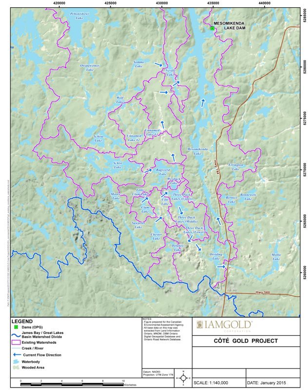
Source: IAMGOLD Corporation, January 2016.
Figure C-2 Anticipated local watershed boundaries and flow directions within the Mollie River and Mesomikenda Lake subwatersheds, including retention dams and watercourse realignments that will be in place from the end of construction until the open pit is filled at the end of stage 1 of the abandonment phase
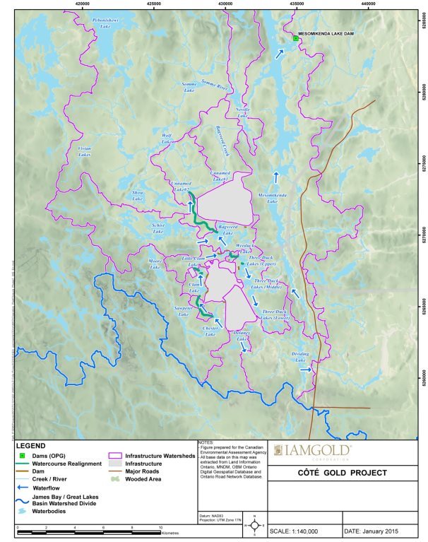
Source: IAMGOLD Corporation, January 2016.
Figure C-3 Anticipated local watershed boundaries and flow directions within the Mollie River and Mesomikenda Lake subwatersheds, including retention dams and watercourse realignments that will be in place at the end of stage 2 of the abandonment phase.
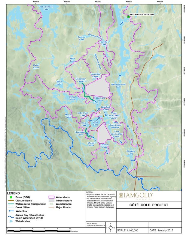
Source: IAMGOLD Corporation, January 2016.
Appendix D Proposed Water Management Systems
This appendix elaborates on the project overview (Chapter 2) and map of project components (Figure 2-2) to provide additional information about how water will be managed at the mine site, throughout each phase of the Project.
Water management during the construction and operation phases
Water management systems, including ditches, collection ponds, water pipelines, the mine water pond, the polishing pond, and associated pumping equipment, would be installed during the construction phase in advance of mining operations. During the operation phase, contact water in the open pit would be removed by pumping to the mine water pond. Contact water at the mine rock area would be collected into a series of collection ponds that would be connected by ditches around the perimeter of the mine rock area. Dedicated ditches would be built around the overburden stockpile to direct contact water to the mine rock area collection ponds. Contact water from the low-grade ore stockpile would also be collected into a series of collection ponds, which would be connected by ditches around the perimeter of the stockpiles. Berms would be built at the edge of the collection ponds for the low-grade ore stockpiles, and liners would be used on the berms to prevent seepage losses into the open pit. Water from the mine rock area and low grade ore stockpile collection ponds would be pumped to the mine water pond. The mine water pond would be lined to prevent seepage losses into the open pit.
Water in the mine water pond would be delivered to the ore processing plant. The tailings produced from ore processing and process water would be treated at the process plant to remove dissolved metals and ions, including cyanide used in ore processing. Treated water from the process plant would be discharged by pipeline into the tailings management facility, where any residual cyanide would be destroyed by exposure to sunlight.
The tailings management facility would store tailings solids, with water draining towards a reclaim pond. Tailings dams would be built along the perimeter of the tailings management facility, with starter dams protected by geomembrane liners to minimize seepage losses. Contact water from tailings management facility dams and seepage losses would be collected in a series of seepage ponds, with connecting ditches around the perimeter. The collected water would be pumped back to the reclaim pond, where water may be recycled back to the processing plant for reuse.
Excess water in the mine water pond would be directed by pipeline to the polishing pond, and from there could be recycled back to the processing plant for reuse, or directed to the tailings management facility reclaim pond. Excess water in the polishing pond would be discharged into the environment by a pipeline into Neville Lake, at the outflow of Bagsverd Creek. If required prior to discharge, the water would be further treated to remove suspended solids and metals to meet Metal Mining Effluent Regulations and Ontario regulations. Seepage losses from the polishing pond would be collected and pumped back to the polishing pond, if necessary.
Small volumes of freshwater would be drawn from Mesomikenda Lake for potable water, truck washing and fire reserve requirements. Treated sewage effluent could be discharged into the environment or recycled along with other waters on the mine site.
Water management during the decommissioning phase and stage 1 of the abandonment phase
During the decommissioning phase and stage 1 of the abandonment phase, the mine water pond would be drained by pumping into the open pit. The mine water pond would then be revegetated. The area of the ore processing plant and associated infrastructure would also be revegetated. Ditches alongside site roads would be removed and revegetated. The water intake pipe from Mesomikenda Lake would be removed.
Approximately 25 percent of the mine rock area would be revegetated during the decommissioning phase and stage 1 of the abandonment phase. Contact water in collection ponds at the mine rock area would be pumped into the open pit. The area of the low-grade ore stockpile would be revegetated. The proponent does not anticipate any remaining stockpiles of low-grade ore after the operation phase; however, if stockpiles remain, they would be revegetated in a similar manner as the mine rock area. The tailings management facility reclaim pond and the polishing pond would be drained by pumping back towards the open pit. The polishing pond and the dry areas of the tailings management facility would be progressively revegetated. Ditches and collection ponds adjacent to the tailings management facility would remain in place, although the ditches would be allowed to drain naturally. Any surface drainage from the revegetated tailings management facility would passively discharge into a natural channel to the middle basin of Mesomikenda Lake, while surface drainage from the polishing pond would passively discharge into Bagsverd Creek.
Water management during stage 2 of the abandonment phase
During stage 2 of the abandonment phase, after the open pit has filled, pumping from the mine rock area collection ponds to the open pit would cease if the contact water is deemed to be of suitable quality. The mine rock area collection ponds would be removed and revegetated. The contact water from the mine rock area would then passively discharge into Delaney Lake, Chester Lake and Lower Three Duck Lake, and the mine rock area seepage collection ponds would be drained and revegetated.
Appendix E Summary of Aboriginal Consultations
This appendix provides a summary of comments received during the course of the environmental assessment. Most of the full comments and responses are found in the Environmental Impact Statement documentation provided by the proponent[14]. The Agency has synthesized all comments received during all phases of the environmental assessment and categorized them according to valued components and environmental assessment components.
|
Group |
Summary of Comment |
Summary of Proponent's Response |
Agency Response |
|---|---|---|---|
|
Current Use of Lands and Resources for Traditional Purposes |
|||
|
Wabun Tribal Council, Métis Nation of Ontario |
The project footprint is not an accurate reflection of the traditional area that will be impacted, considering additional areas will be affected by air, noise, traffic, health and safety, and other issues. Identified direct loss or restriction of access to travel routes, including navigation and portage routes, sites, areas, and wildlife and plant resources of importance for the exercise of rights, inclusive of harvesting rights, and fish species of interest (bass, burbot/ling cod, northern pike/jackfish, pickerel/walleye, and trout, sauger and perch). |
The Project has been designed to be as compact as possible to minimize changes in access. Suitable canoe and portage routes will be established to ensure routes remain usable. It applied an integrated methodology using indicators to predict effects on all areas of the environment, including Aboriginal groups and committed to continue to discuss potential project effects on traditional activities with potentially affected Aboriginal groups throughout the life the Project. The impact assessment concluded no additional areas outside the project footprint would be rendered unavailable for traditional uses. Some areas around the project footprint may require controlled access and traditional uses may continue dependent on project activities. The Project may displace some wildlife species within one to five km of human infrastructure. The analysis of the Highway 144 traffic, comparing existing traffic to construction phase traffic showed a negligible increase in noise levels. |
The Agency has considered potential impacts to the current use of lands and resources for traditional purposes, taking into account all available information, including the traditional knowledge and traditional land use studies provided. The Agency assumes that the final project boundary would include areas between and around each project component and will likely be informed by modelled air quality exceedances to satisfy Province of Ontario legislative requirements. The Agency recommends, for consideration in the Minister's Decision Statement, that the proponent use best available information and knowledge, including community and Aboriginal traditional knowledge, to inform actions in implementing the Project. Furthermore, the Agency recommends, for consideration in the Minister's Decision Statement, consultation with potentially affected Aboriginal groups as a requirement in relation to the following key mitigation and follow-up measures described in Subsection 7.3.3 and Appendix G of the Report:
|
|
Wabun Tribal Council |
The magnitude of the impact of non-traditional hunters in the area used by the Mattagami First Nation when the transmission line is constructed has been underestimated. There is no biological basis to the study area for impacts from the transmission line. |
The proponent predicts no significant effects on wildlife populations in relation to its preferred transmission line alignment. In accordance with the Environmental Impact Statement Guidelines, levels of uncertainties are included in the assessment, where applicable. A level of magnitude was assigned for this potential impact and no additional information is required to support the effects prediction for this indicator. The selection of the study area does not limit the scope of the prediction of effects and the justification for the extent of each study area is provided in the Amended Environmental Impact Statement. |
The Agency has considered impacts associated with increased access by hunters along the transmission line alignment and notes the proponent has committed to continued engagement with potentially affected Aboriginal groups throughout the life the Project. The Agency acknowledges that increased access cannot be completely avoided or mitigated. The Agency notes that, with the exception of migratory birds, the Province of Ontario regulates hunting in the province. |
|
Métis Nation of Ontario |
Identified that changes to wildlife and plant populations and distributions, as well as potential contamination, resulting from the Project may have serious impacts on hunting and other traditional land use activities and should be mitigated and accommodated. |
Impacts to wildlife and plant populations and distributions are predicted not to be measurable in the local and regional study area. With the exception of developing on-site wildlife management plans, no additional mitigation is warranted to prevent significant impacts. |
The Agency has considered potential impacts to wildlife and plant populations and distributions, the potential for contamination of traditional foods, and the related effects to current use of lands and resources for traditional purposes. In addition to key mitigation in Subsection 7.2.3 and Appendix G of the Report in relation to migratory birds, the Agency recommends, for consideration in the Minister's Decision Statement, consultation with potentially affected Aboriginal groups as a requirement in relation to the following key mitigation and follow-up measures described in Subsection 7.3.3 and 7.4.3, and Appendix G of the Report:
|
|
Métis Nation of Ontario, Wabun Tribal Council |
Noted that given the uncertainty of the anticipated timeline for project construction, there is a high potential for changes to occur to environmental baseline conditions which would impact traditional land uses and socio-economic land uses. |
The proponent considers changes to the baseline environment unlikely in the absence of any mining activity. It will continue to monitor various aspects of the environment between completion of the environmental assessment and commencement of the Project and use this information to support permitting processes and environmental management plans. |
The Agency recommends, for consideration in the Minister's Decision Statement, that the proponent use best available information and knowledge, including community and Aboriginal traditional knowledge, to inform actions in implementing the Project. Furthermore, the Agency recommends, for consideration in the Minister's Decision Statement, that the proponent prepare and submit an annual report to the Agency, make that report available to the public, including Aboriginal groups, and consult with Aboriginal groups prior to initiating any material change(s) to the Project that may result in adverse environmental effects. Furthermore, the Agency recommends, for consideration in the Minister's Decision Statement, consultation with potentially affected Aboriginal groups as a requirement in relation to the following key mitigation and follow-up measures described in Subsection 7.3.3 and Appendix G of the Report:
|
|
Wabun Tribal Council, Métis Nation of Ontario |
Requested additional information on the baseline methodology for the traditional knowledge and land use study (e.g. questionnaire, study areas, objectives). Identified data limitations, gaps in the effects assessment (e.g. trapping) and identified that comments about potential effects were not documented accurately. |
The assessment accurately describes the information contained in Wabun Tribal Council's traditional knowledge and traditional land use study as well as comments expressed by Aboriginal groups. The traditional study area was provided by the Aboriginal groups in a study that was developed by a consultant selected by the Wabun Tribal Council. The Project will not limit the ability to carry out traditional activities in the area. Traditional trapping was not selected as an indicator for the effects assessment because no specific trap lines or trap areas were identified by Aboriginal peoples during the study. The Métis Nation of Ontario traditional knowledge and land use study was submitted to the proponent and it determined no changes were required. |
The Agency sought clarification from Aboriginal groups during the course of the environmental assessment on potential effects to current use of lands and resources for traditional purposes to validate the information presented by the proponent. Furthermore, the Agency required the proponent to consider any information provided by Aboriginal groups during all phases of the environmental assessment process in its effects analysis. The Agency has summarized information on traditional land use in Section 7.3 of the Report. |
|
Brunswick House First Nation |
Emphasized the need for the environmental assessment to strongly consider impacts to water systems, plants, and soils. |
Comment provided to the Agency early in the environmental assessment process and no proponent response requested. |
The Agency has considered potential impacts of the Project on watersheds, plants, and soils, as well as the impacts of the Project on the current use of lands and resources for traditional purposes. Brunswick House First Nation has indicated that they are satisfied with the plans the proponent has in place to mitigate impacts. |
|
Wabun Tribal Council, Métis Nation of Ontario |
Requested clarification about potential effects to wildlife and habitat, including moose and other ungulates, amphibians, and furbearer populations. Asked for policy for dealing with wildlife within the project footprint. |
The proponent predicts that the biological function of terrestrial fauna, flora and wetlands will not be significantly impacted by the Project. It was acknowledged that the Project may displace a few individuals in a population but that these effects would not be measurable at the population level. It was noted that the habitat found is common throughout the study areas. On-site traffic impacts to wildlife will be mitigated through strict enforcement of site speed limits. Ongoing monitoring of wildlife interactions and daily observations within the project footprint will be used to identify wildlife activity areas along roadways and right-of-way. Policies such as a stop work policy and a no hunting policy will protect wildlife onsite and assist in tracking wildlife populations. |
The Agency has considered potential impacts of the Project on wildlife species, in the context of potential effects on the current use of lands and resources for traditional purposes and changes to the environment, and effects of those changes, that are directly linked or necessarily incidental to federal decisions that may be required for the Project. This information has been summarized in Sections 6.4, 7.3 and 7.6 of the Report. Furthermore, the Agency recommends, for consideration in the Minister's Decision Statement, consultation with potentially affected Aboriginal groups as a requirement in relation to the following key mitigation and follow-up measures described in Subsection 7.3.3 and Appendix G of the Report:
|
|
Wabun Tribal Council, Métis Nation of Ontario |
Identified potential effects to habitat quantity and the local distributions and migratory patterns of wildlife, such as destruction of land and water from overprinting by project components, habitat fragmentation caused by access roads and other infrastructure (including the transmission line alignment) and potential effects to the local distributions and migratory patterns of wildlife. Also, indicated a lack of support for justification in choosing the Cross-Country transmission line alignment. |
The proponent predicts that the biological function of terrestrial fauna, flora and wetlands will not be significantly impacted by the Project. It is acknowledged that the Cross-Country alignment will result in habitat fragmentation effects but these effects would not result in significant impacts on wildlife. As the Cross- Country alignment is significantly shorter it will result in substantially less vegetation required to be cleared in comparison to the alternative Shining Tree alignment. Also, further widening of the Shining Tree alignment in addition to the existing transmission line corridor would further expose wildlife to predators and widen the fragmentation along this corridor. |
The Agency has considered potential impacts of the Project on the current use of lands and resources for traditional purposes, including how changes in habitat quality and wildlife species as a result of habitat loss and fragmentation would affect those uses. The transmission line alignment options each have different potential environmental effects: the Cross-Country transmission line alignment is 40 km shorter and the Shining Tree alignment results in further widening of the existing disturbance. The Agency acknowledges the proponent has committed to designing a compact project footprint, minimizing the width of the transmission line alignment to 50 m, utilizing existing infrastructure for access and minimizing the construction of new roads and other corridors wherever alternatives exist. Key mitigation and follow-up measures described in Subsections 7.2.3 and 7.3.3, and Appendix G of the Report include:
|
|
Métis Nation of Ontario, Wabun Tribal Council |
Identified the need for a monitoring program for potential effects to traditional land use, including wildlife, ceremonial sites, and medicinal plants. Requested involvement in ongoing monitoring plans. |
The proponent committed to work collaboratively with the affected Aboriginal groups to discuss potential effects on traditional activities and identify a monitoring program, as required. |
The Agency has considered the need for additional monitoring programs to verify effects to traditional land use, ceremonial sites, and medicinal plants. The Agency recommends, for consideration in the Minister's Decision Statement, that the proponent use best available information and knowledge, including community and Aboriginal traditional knowledge, to inform actions in implementing the Project. This would include consulting potentially affected Aboriginal groups, and undertaking monitoring and analysis to determine the effectiveness of any mitigation measures. Furthermore, the Agency recommends, for consideration in the Minister's Decision Statement, consultation with potentially affected Aboriginal groups as a requirement in relation to the following key mitigation and follow-up measures described in Subsections 7.3.3 and 7.5.3, and Appendix G of the Report:
|
|
Wabun Tribal Council |
Requested additional information in the alternatives assessment to substantiate conclusion that mine rock area will contain vegetation comparable to baseline conditions. |
The proponent committed to monitor the success of similar plans and engage Aboriginal groups throughout the Project. It will apply adaptive management approaches to achieve the goals of closing the site as required by provincial legislation. |
The Agency has considered the proponent's response and recognizes that habitat regeneration, inclusive of the flooding of the open pit, mine rock area and tailings management facility, will take time. The Agency notes that full restoration of the project footprint to a condition that replicates the pre-project environment is not possible. The Agency understands that the mine closure requirements of the Province of Ontario's Mining Act includes consultation with potentially impacted Aboriginal groups. Furthermore, the Agency recommends, for consideration in the Minister's Decision Statement, consultation with potentially affected Aboriginal groups as a requirement in relation to the following key mitigation and follow-up measures described in Subsection 7.3.3 and Appendix G of the Report:
|
|
Métis Nation of Ontario, Mattagami First Nation, Wabun Tribal Council |
Requested that objectives of the closure plan ensure that impacted sites are returned to a productive state to support traditional harvesting. Identified gaps in the closure plan, including plans to remove the transmission line, and the commitment that vegetation on the mine rock area will be of comparable quality to baseline conditions. Asked whether the site can actually be fully rehabilitated for future use and what the site would look like following decommissioning and abandonment. Identified that the length of time required for site closure is too long. |
The proponent committed to considering this comment during the preparation of the Mine Closure Plan. After abandonment the vegetation quality will be of comparable productivity to baseline conditions. The level of information provided on progressive re-vegetation and closure is suitable for the purpose of an environmental assessment. The proponent noted that the duration of the abandonment phase is based on the expected duration for the open pit to flood. |
The Agency understands that the mine closure requirements of the Province of Ontario's Mining Act includes consultation with potentially impacted Aboriginal groups and considers future land and resource use. The Agency also understands that the length of time associated with the site closure is similar to the abandonment phases described in Section 2 and Appendix C of the Report. Abandonment Stage 1 will be completed when the open pit has filled. If more aggressive regeneration of the open pit is undertaken, environmental effects could result in areas from which the water is taken. The Agency acknowledges the proponent's commitment to restore the site to a condition that allows for productive plant harvesting following decommissioning. The Agency understands that habitat regeneration will take time and that full restoration of the project footprint to a condition that replicates the pre-project environment is not possible. Key mitigation and follow-up measures described in Subsection 7.3.3 and Appendix G of the Report include measures described in the row above. |
|
Wabun Tribal Council |
Identified that specific measures were not taken to consult with Aboriginal land users concerning the residual effects on the visual environment. |
The only visual aesthetics-related comment received from Aboriginal groups during open houses indicated that groups are interested in understanding the potential effects on land near the Project. As a result of the comment, the proponent added an effect assessment indicator and mapping to show where project components may be visible from both lakes and land. |
The Agency has considered potential aesthetic impacts of the Project and acknowledges the proponent's commitment to limiting the extent of the visual effects such as constructing a single mine rock area located further away from sensitive receptors and limiting the design height of the mine rock area to the predicted maximum of 150 m. |
|
Aboriginal Health and Socio-Economic Conditions |
|||
|
Métis Nation of Ontario, Wabun Tribal Council |
Identified potential effects from release of methylmercury due to flooding and expressed concern with any changes to existing fish consumption advisories. Requested baseline fish tissue and water quality sampling, pathways assessment, additional mitigation measures, and plans for fish tissue monitoring. |
The proponent responded to comments on the technical methodology and provided additional information, including adding both mercury and methylmercury as parameters for water quality sampling and made changes to mitigation measures to address methylmercury production. |
The Agency has considered potential effects to Aboriginal health associated with the consumption of contaminants in fish. Key mitigation and follow-up measures described in Subsection 7.4.3 and Appendix G of the Report include:
|
|
Métis Nation of Ontario |
Requested explanation of the source of lead and cadmium contamination identified in baseline sampling results from Côté Lake and a commitment to include cadmium and lead in fish tissue sampling if elevated concentrations are detected in surficial sediments during mine operations. |
Cadmium and lead baseline results indicating contamination are anomalous due to sampling or analytical error and do not reflect actual baseline conditions. In all instances fish muscle tissue concentrations of cadmium and lead were well below consumption benchmarks in baseline studies, and ongoing sampling for cadmium and lead in fish tissue was not identified as being required. |
The Agency acknowledges the proponent's response and notes its commitment to monitor groundwater and surface water for parameters including cadmium and lead. |
|
Métis Nation of Ontario |
Raised potential human health effects from herbicide use along transmission lines. |
The proponent committed to avoid the use of chemical agents for vegetation clearing along transmission line right of way. |
The Agency acknowledges the proponent's commitment to avoid using chemical agents to control vegetation along the transmission line alignment. This has been identified as key mitigation in Subsection 7.3.3 of the Report. |
|
Mattagami First Nation |
Identified concern with potential drinking water contamination and asked where waste material would go (including arsenic and mercury). |
The Project will not use arsenic or mercury. The only hazardous material being used is cyanide, which will be destroyed prior to leaving the ore processing plant. The environmental assessment process has evolved to address historic mining issues such as arsenic and mercury being deposited into water ways. |
The Agency has considered potential impacts of the Project on Aboriginal health, including waste water discharges and consumption of contaminated water. The Agency notes the proponent will be required to meet Fisheries Act and Metal Mining Effluent Regulations. The Agency also recognizes that the proponent will have requirements imposed by the Province of Ontario. The Agency also notes there will be periodic discharges of effluent into Neville Lake that may cause occasional exceedances of provincial and federal drinking water standards for antimony and arsenic within a localized area. The Agency understands the initial effluent mixing zone is not considered a drinking water source, and the proponent anticipates that these exceedances would be infrequent and localized to the initial effluent mixing zone. The proponent must manage domestic waste associated with the work camp in a manner that meets federal and provincial sewage discharge requirements. Key mitigation and follow-up measures described in Subsections 7.1.3 and 7.4.3, and Appendix G of the Report include:
|
|
Mattagami First Nation |
Concern about health of future generations and the land. |
Proponent acknowledged these types of concerns and identified it is committed to working closely with Aboriginal groups. |
The Agency acknowledges the strong connections that Aboriginal groups have to the lands and waters within their traditional areas and that these connections have importance across generations. The Agency also acknowledges that some areas of the mine site will affect the continued ability to exercise rights within these areas and that these effects may last for multiple generations. The Agency is of the view that effects in the local and regional study areas will not affect the health of Aboriginal groups, including the health of future generations, but recognizes that full restoration of some areas to a condition that replicates the pre-project environment is not possible. |
|
Wabun Tribal Council |
Requested revision of the Ecological Health Risk Assessment to include the potential exposure of waterfowl and shorebirds to the tailings management facility. |
An assessment was completed for terrestrial receptors potentially exposed to contaminants of concern resulting from aerial deposition and aquatic and terrestrial receptors exposed directly or indirectly to contaminants present in discharged effluent. The risk of ecological receptors, such as waterbirds and shorebirds, being exposed to contaminants in the tailings management facility does not require evaluation because the tailings management facility is not considered a suitable ecological habitat for ecological receptors. |
The Agency is of the view that there is a potential for ungulates and birds to come into contact with contaminated water at the tailings management facility and polishing pond. Key mitigation and follow-up measures described in Subsection 7.4.3 and Appendix G include:
|
|
Métis Nation of Ontario |
Requested information about potential impacts from dust. |
Information on potential impacts of dust on human and other ecological receptors was provided. |
The Agency acknowledges the proponent's response and has summarized potential impacts of dust on migratory birds and human health in Sections 7.2 and 7.4 of the Report respectively. Key mitigation and follow-up measures described in Subsection 7.4.3 and Appendix G of the Report include:
|
|
Wabun Tribal Council |
Identified that the use of mine water for dust suppression may spread contaminants and requested an alternative source of water be identified. |
Any contact water used for dust suppression will only be in areas that drain towards the open pit or the mine rock area collection ponds. Should dust suppression be required in other areas, the proponent would either use other dust suppression measures or a separate fresh water source such as Mesomikenda Lake. |
The Agency has reviewed the proponent's plan to use mine water as a source of water for dust suppression in areas that drain towards the open pit or the mine rock area. The Agency agrees that the proponent should not spread contamination. Key mitigation and follow-up measures described in Subsections 7.1.3 and 7.4.3, and Appendix G of the Report include:
|
|
Wabun Tribal Council |
Requested the chemicals of concern assessment include consideration of the potential additive effects of exposure to multiple chemicals of concern. |
The proponent identified that additive and synergistic effects resulting from exposure to multiple chemicals is a factor that required consideration. For compounds that target a specific organ or operate via a common mechanism of action, additivity is often assumed to address the potential for cumulative effects. It acknowledged that addressing additive effects from multiple stressors that operate on multiple organ systems is much more difficult and as pointed out is typically dealt with in the uncertainty section where it is acknowledged that owing to simultaneous exposure to multiple chemicals that may operate synergistically, there is the possibility that risks are underestimated. It noted that most of the parameters identified as chemicals of concern are essential nutrients and are not expected to be present at concentrations that present a risk. |
The Agency has considered potential impacts of the Project on Aboriginal health, including the potential for additive effects associated with exposure to chemicals of concern. The Agency is of the view that key mitigation and follow-up measures described in Subsections 7.1.3 and 7.4.3, and Appendix G of the Report would reduce this risk:
|
|
Wabun Tribal Council, Métis Nation of Ontario |
Identified gaps in the socio-economic baseline information, requested additional information to better understand impacts and requested opportunities for continued engagement. |
The proponent studied the impacts of noise, air quality, water quality and hydrology and found no significant impacts. No significant adverse effects to socio-economic conditions of Aboriginal peoples due to environmental changes have been predicted. Best practices were implemented and reasonable efforts were made to obtain socio-economic information through primary and secondary research to inform the socio-economic baseline studies and effects assessment. It also reviewed the Métis Nation of Ontario traditional knowledge and traditional land use study and did not expect any negative effects on Métis businesses or outfitters. The proponent committed to developing a socio-economic community management plan in consultation with Aboriginal groups to monitor and support enhanced benefits to local Aboriginal businesses. |
The Agency has considered impacts of the Project on Aboriginal socio-economic conditions based on the available information. The Agency acknowledges and expects the proponent to honour its commitment to work with Aboriginal groups to confirm adverse environmental effects to socio-economic conditions do not occur and develop a socio-economic community management plan in consultation with Aboriginal groups to monitor and support enhanced benefits to local Aboriginal businesses. |
|
Physical or Cultural Heritage, and Effect on Historical, Archaeological Sites or Structures |
|||
|
Mattagami First Nation, Wabun Tribal Council |
Expressed importance of protecting water and the life that it brings to future generations. Also identified the importance of engaging women from the community. Requested that a water ceremony be conducted in dialogue with women in the community, who traditionally lead water ceremonies. |
The proponent is open to hosting a water ceremony on the site and continuing dialogue with the women of the community to arrange for a water ceremony. |
The Agency has considered potential impacts of the Project on water and notes the proponent's commitment to work with the women of Mattagami First Nation to arrange for a water ceremony. |
|
Métis Nation of Ontario |
Identified impacts and restriction of access to historical gathering places, spiritual sites, important landscape features, a historic trading or Hudson Bay Company Post(s), and former village and burial site. |
The proponent reviewed the Métis Nation of Ontario traditional knowledge and land use study and found that no changes or impacts on conclusions were required. |
The Agency has considered potential impacts of the Project on Métis based on the information provided in the traditional knowledge and traditional land use study as well as other sources. Key mitigation measures described in Subsection 7.5.3 and Appendix G of the Report include: avoid, protect or recover archaeological artifacts discovered during all project phases, in accordance with the Ontario Heritage Act and associated regulations and protocols, and notify the appropriate Aboriginal groups. |
|
Wabun Tribal Council, Métis Nation of Ontario |
Identified need for local First Nations involvement during archaeological work. Asked whether any Métis archaeological sites were identified. |
There was extensive and continuous field involvement of Elders and Band members from Wabun Tribal Council to assist in identifying areas of high archaeological potential and in testing and excavating sites. If any additional sites with archaeological potential are identified through construction and operation, then the proponent will notify Aboriginal groups and will provide opportunities for participation. There were no Métis sites identified. |
The Agency acknowledges the proponent's commitment to continued engagement with Aboriginal groups. Key mitigation measures describe in Subsection 7.5.3 and Appendix G of the Report include:
|
|
Mattagami First Nation, Wabun Tribal Council |
Identified potential impacts to Ojibwe cultural values due to the removal of the bald eagle nest and habitat loss impacting local bald eagle populations. Identified the need for culturally appropriate mitigation. |
The proponent indicated it does not predict local bald eagle populations as a whole to be impacted by the Project and the biologists found numerous empty nests in the vicinity that could be occupied by the bald eagle. The removal of the bald eagle nest would have to be approved by the Ministry of Natural Resources and Forestry in consultation with Aboriginal groups on how the removal of the nest can be conducted in a culturally sensitive manner. The proponent is open to hosting traditional ceremonies onsite. |
The Agency has considered impacts of the loss of the bald eagle nest, a culturally important species to many Aboriginal groups. The Agency has identified as a key mitigation measure in Subsection 7.5.3 and Appendix G of the Report that the removal of eagle's nests be done in accordance with Ontario's Fish and Wildlife Conservation Act and in a culturally sensitive manner, and engage with Mattagami First Nation and Flying Post First Nation in doing so. |
|
Fish and Fish Habitat |
|||
|
Wabun Tribal Council, Métis Nation of Ontario |
Impacts to commercial, recreational and Aboriginal fisheries and forage fish should be assessed (the Environmental Impact Statement assessed impacts to sport fish only). |
Commercial, recreational and Aboriginal fisheries included sport fish and forage fish that support these species and impacts on these activities have been assessed. The term "sport fish" was used incorrectly and was corrected to commercial, recreational, and Aboriginal fisheries in the Amended Environmental Impact Statement. The water quality impact assessment indirectly includes protection of forage fish and their habitat. |
The Agency has considered impacts to commercial, recreational and Aboriginal fisheries, including forage fish. The Agency acknowledges the proponent's commitment to work with Aboriginal groups and Fisheries and Oceans Canada to satisfy the requirements of the Fisheries Act. Key mitigation measures described in Subsection 7.1.3 and Appendix G of the Report include:
|
|
Métis Nation of Ontario |
Requested additional information on the timing of construction and operation activities and the interaction of these activities with fish and fish habitat. |
While the exact construction start dates and timelines are not known, the proponent committed to ongoing consultations on the timing of site construction including avoidance of in-water works during spawning periods. Interactions of project activities with fish and fish habitat and mitigation measures for potential effects are described in Chapter 10 of the Amended Environmental Impact Statement. |
The Agency and federal authorities have considered the timing of construction and potential effects to fish and fish habitat for all project phases. The Agency acknowledges the proponent's commitment to work with Aboriginal groups and Fisheries and Oceans Canada to satisfy the requirements of the Fisheries Act. Key mitigation measures described in Subsection 7.1.3 and Appendix G of the Report include the measures described in the row above. |
|
Wabun Tribal Council, Métis Nation of Ontario |
Requested additional detail about the proponent's plans for offsetting losses to fish and fish habitat from watercourse realignments, including rationale for how impacts will be adequately mitigated. Seeking a commitment to be consulted on detailed plans for fish and fish habitat mitigation, compensation and monitoring. |
The proponent provided additional information about offsetting any serious harm to fish from the proposed watercourse realignments, including plans to transplant vegetation, benthic invertebrates and forage fish. The proponent committed to consulting Aboriginal groups during the Fisheries Act application process and outlined that Aboriginal groups will be consulted on regulatory submissions which are required to support approvals of the Project. |
The Agency notes that the proponent and Fisheries and Oceans Canada are committed to engaging with potentially affected Aboriginal groups during the Fisheries Act application and regulatory process. Key mitigation measures described in Subsection 7.1.3 and Appendix G of the Report include the measures described two rows above. |
|
Wabun Tribal Council, Métis Nation of Ontario |
Requested additional information about the effects of blasting on critical fish life stages. |
The shockwave associated with blasting will not be lethal to fish present in water bodies adjacent to the site. In addition, there is limited fish spawning habitat along the pit wall areas. The assessment of the potential effects of blasting on fish is included in Chapter 9 of the Amended Environmental Impact Statement. |
The Agency and federal authorities have considered potential effects of blasting activities on fish and fish habitat including disruption to spawning habitat in Clam Lake. Key mitigation measures described in Subsection 7.1.3 and Appendix G of the Report includes implementing an offsetting plan that accounts for increased noise and vibrations from blasting in the open pit. |
|
Wabun Tribal Council |
Identified potential impacts to water quality during the watercourse realignments and draining of Côté Lake, including increases in contaminants such as total suspended solids, and requested additional information to demonstrate the efficacy of erosion controls. |
Côté Lake already drains into Three Duck Lake, and the two lakes have similar water quality, so the draining of Côté Lake would not negatively affect water quality in Three Duck Lake. Similarly, watercourse realignments would establish connections between water bodies with similar water quality, and negative effects to water quality would not be expected from the realignments. Best management practices will be used to control erosion. |
The Agency has considered potential changes to water quality resulting from the Project, and its potential effects on fish and fish habitat. The Agency notes the proponent will be required to manage water quality in mine effluent to meet the Metal Mining Effluent Regulations, and in all water bodies surrounding the Project to meet the requirements of the Fisheries Act, while taking into account the Canadian Council of Ministers of the Environment's, Canadian Water Quality Guidelines for Protection of Aquatic Life. Key mitigation measures described in Subsection 7.1.3 and Appendix G of the Report include:
|
|
Wabun Tribal Council, Métis Nation of Ontario, Flying Post First Nation |
Requested additional information, including baseline information, to fully understand watercourse realignments, changes to groundwater levels and water quality impacts on terrestrial fauna, wetlands, fish, wildlife, turtles, and ecosystems in all water bodies. |
The biological function of terrestrial fauna, flora and wetlands is not predicted to be significantly impacted by the Project. Additional detail was provided detailed wetland baseline information and predicts changes will not eliminate any plant community types, including wetlands. Dewatering of water bodies and watercourse realignment will affect habitat quality, influencing the quantity of some wetlands. The implementation of a natural channel design approach to the watercourse realignments will provide suitable habitat for larger mammals. A monitoring program is proposed which includes well nests adjacent to select hydrological monitoring stations to determine groundwater and surface water interactions. This program will be integrated with the water quality, hydrology, aquatic biology and terrestrial ecology monitoring programs. |
The Agency has considered potential impacts of changes to watercourse realignments including impacts on wetlands, and terrestrial plant and wildlife species identified as being of importance to Aboriginal groups. The Agency acknowledges the proponent's commitment to incorporate suitable habitat for terrestrial fauna when implementing the offsetting plan and its commitment to maintaining the natural water flows and levels within the realignments. The Agency recommends, for consideration in the Minister's Decision Statement, that the proponent use best available information and knowledge, including community and Aboriginal traditional knowledge, to inform actions in implementing the Project. This would include consulting Aboriginal groups, and undertaking monitoring and analysis to determine the effectiveness of any mitigation measures. Key mitigation measures are described in Subsection 7.1.3 and Appendix G of the Report. |
|
Wabun Tribal Council, Mattagami First Nation, Métis Nation of Ontario, Brunswick House First Nation |
Concerned about impacts to water quality. For instance, identified the potential for significant impacts from the release of deleterious substances at the mine site including the tailings management facility and inquired about the treatment of open pit and polishing pond discharges during abandonment. In addition, sought clarification on the groundwater and surface water quality assessment, methodology and requested additional information on whether site-specific water quality objectives would be provided, and if so, stated they should be included in the Environmental Impact Statement. |
The proponent provided clarification and rationale for its assessment methodology. The proponent committed, when necessary, to further effluent treatment to ensure acceptable levels are met. Furthermore, the proponent described mitigations and components of project design that will be implemented to ensure that water quality remains well below criteria and guideline limits. The polishing pond will be removed during the decommissioning phase and the proponent is committed to treating any flow from the open pit, if required. The open pit discharges are expected to meet Provincial Water Quality Objectives and the Canadian Council of Ministers of the Environment's Canadian Water Quality Guidelines for Protection of Aquatic Life. |
The Agency and federal authorities have considered the proponent's water quality assessment methodologies and potential changes to water quality in the context of effects on fish and fish habitat. The Agency notes the proponent will be required to manage water quality in mine effluent to meet the Metal Mining Effluent Regulations, and in all water bodies surrounding the Project to meet the requirements of the Fisheries Act. The proponent will also be required to work with the Ontario Ministry of the Environment and Climate Change to develop receiver-based effluent discharge criteria consistent with provincial water quality management policies and provincial water quality objectives. The Agency acknowledges the proponent's commitment to remove and revegetate the polishing pond after operations, monitor surface water quality in water bodies at the mine site through all project phases and to ensure that concentrations of metals such as zinc, copper and iron in the effluent mixing zone are below levels that are harmful to aquatic life. Key mitigation measures described in Subsection 7.1.3 and Appendix G of the Report include:
|
|
Wabun Tribal Council, Métis Nation of Ontario |
Identified that the extent of the mixing zone had not been defined, and asked that the proponent consider ways to supplement water flow rates to ensure effluent limits are met and that aquatic life is protected. |
Two potential effluent discharge options were evaluated – in Neville Lake, at the outflow of Bagsverd Creek and the upper-middle basin of Mesomikenda Lake. Neville Lake was preferred due to the lesser predicted effect on water quality. The extent of the mixing zone would be further defined as part of the provincial Environmental Compliance Approval process. Discharge from the polishing pond into Neville Lake would only occur when receiving water conditions are suitable. |
The Agency and federal authorities have considered the proponent's water quality assessment methodologies and potential changes to water quality in the context of effects on fish and fish habitat. The Agency acknowledges that the proponent has committed to recycling mine water in a manner that would reduce the frequency and duration of effluent discharge. Key mitigation measures described in Subsection 7.1.3 and Appendix G of the Report include minimizing the release of untreated effluent into the environment and managing effluent discharges and surface water quality during all phases to be in compliance with the Metal Mining Effluent Regulations and the Fisheries Act. |
|
Wabun Tribal Council, Métis Nation of Ontario |
Identified potential impacts from acid generation and metal leaching, asked questions about the technical methodology, and requested additional information about proposed mitigation measures for impacts from run-off and seepage, including a mine rock waste management plan. |
A comprehensive investigation and evaluation of the metal leaching / acid rock drainage characteristics of waste rock and tailings has been completed and documented. The percentage of potentially acid generating rock is expected to be low and well distributed throughout the overall mine rock, metal leaching is expected to be low and no specific management of potentially acid generating and metal leaching rock is required. Contingency plans would be used should monitoring results identify a need to treat effluent for acid or metal leaching. |
The Agency and federal authorities have considered the proponent's water quality modelling methodologies, including determination of metal concentrations in waterways in relation to effects on fish and fish habitat. The Agency notes that the proponent will be required to meet the requirements of Ontario's Mining Act including characterizing, monitoring and handling potentially acid generating rock piles, including low-grade ore stockpiles. Key mitigation measures described in Subsection 7.1.3 and Appendix G of the Report include distributing waste rock in the mine rock area in a manner that minimizes acid generation and metal leaching and implementing measures to collect contact water and seepage. |
|
Wabun Tribal Council |
Identified potential effects to flow rates in Mesomikenda Lake from water taking. |
Freshwater will be taken in accordance with conditions provided in the Permit to Take Water, when approved by the Province of Ontario. The water removal is intended to supplement recycled site water and provide for truck washing, potable and fire reserve requirements. Predicted changes to flow and water level in Mesomikenda Lake were assessed under operational conditions, including lake sensitivity to various climate and removal scenarios. |
The Agency and federal authorities have considered the proponent's water quantity modelling and monitoring methodologies, and the effects on surface water flow in Mesomikenda Lake in relation to effects on fish and fish habitat. Key mitigation measures described in Subsection 7.1.3 and Appendix G of the Report include recycling of water to reduce the need to draw freshwater from Mesomikenda Lake. |
|
Wabun Tribal Council, Métis Nation of Ontario |
Identification of inconsistencies and gaps in baseline data collection methodology, reference sites, and request for additional information to support the effects assessment for fish and fish habitat. |
The proponent provided additional rationale for the baseline methodology and committed to surveys to identify reference areas for monitoring prior to mine construction. Further rationale for the effects assessment methodology and how specific gaps identified by Aboriginal groups were addressed was provided. |
The Agency has considered the proponent's methodology for collection of baseline data and notes that Wabun Tribal Council remains unsatisfied with the proponent's responses for some aspects of the environmental assessment methodology. The Agency recommends, for consideration in the Minister's Decision Statement, that the proponent use best available information and knowledge, including community and Aboriginal traditional knowledge, to inform actions in implementing the Project. This would include consulting Aboriginal groups, and undertaking monitoring and analysis to determine the effectiveness of any mitigation measures. Key mitigation measures described in Subsection 7.1.3 and Appendix G of the Report include continued engagement with Aboriginal groups and Fisheries and Oceans Canada to take into account Aboriginal views and satisfy the requirements of the Fisheries Act to avoid serious harm to fish. |
|
Métis Nation of Ontario |
Asked for clarification on the groundwater and surface water quality monitoring methodology. Requested to be involved in development of monitoring, planning and adaptive management programs. |
A monitoring program is proposed which includes well nests adjacent to select hydrological monitoring stations which will allow for the determination of interactions between groundwater and surface water. Nested groundwater wells, if necessary, will be installed to further observe surface-water groundwater interaction. Surface water monitoring during and after the operation phase will be completed within the local study area and at far-field stations downstream of the current local study area boundary to confirm the water quality model predictions, as required. The proponent is open to Aboriginal participation during the development of environmental management plans. |
The Agency acknowledges the proponent's commitment to continue to engage with Aboriginal groups during all phases of the Project and monitor groundwater and surface water quality at locations on and near the mine site, and in water bodies near and downstream of the mine site. With respect to effluent, the Agency notes the proponent would have to comply with the Metal Mining Effluent Regulations, and understands that part of this requirement includes environmental effects monitoring. |
|
Migratory Birds |
|||
|
Wabun Tribal Council, Métis Nation of Ontario |
Requested additional information on the timing of project construction and operation activities and their interaction with birds, and wildlife. Asked why the bird and wildlife study areas do not include the study area for air, noise and vibration. Requested specific mitigation measures be developed to protect critical life stages for migratory birds and wildlife. |
While the exact construction start dates and timelines are not known, the proponent committed to ongoing consultations on the timing of site construction including avoidance of vegetation clearing during egg incubation periods. The selection of a study area does not limit the scope of the prediction of effects. If the analysis were to show that certain birds or wildlife species are affected by noise within a 5 km radius, then this effect would be considered in the impact assessment. |
The Agency has considered the timing of project construction and operation activities and is generally satisfied with the proponent's response. The Agency is of the view that sensory disturbances to migratory birds would be minimal. The Agency notes that artificial lights from the Project may attract or deter migratory birds, and recognizes Environment and Climate Change Canada's advice that risks to migratory birds from vehicular collisions may increase indirectly as a result of artificial light attracting nocturnal birds such as common nighthawk and eastern whip-poor-will that feed on insects concentrated around light sources. Key mitigation and follow-up measures described in Subsection 7.2.3 and Appendix G of the Report include:
|
|
Wabun Tribal Council |
Identified that the baseline methodology for birds may have led to underrepresentation of species. |
The protocols selected for the Project were consistent with comments provided by the Ontario Ministry of Natural Resources and Forestry and with guidance provided by Environment and Climate Change Canada on similar projects. Statistical analysis of the collected data was used to determine if the appropriate level of effort was expended to assess the effects of the Project on upland breeding bird. |
The Agency, based on expert advice from Environment and Climate Change Canada, is satisfied with the proponent's baseline methodologies for assessing migratory birds. |
|
Group |
Summary of Comment |
Summary of Proponent's Response |
Agency Response |
|---|---|---|---|
|
Wabun Tribal Council, Métis Nation of Ontario |
Noted that they were dissatisfied with some of the proponent's responses provided in the Amended Environmental Impact Statement. |
The proponent continues to engage Aboriginal groups on outstanding concerns. |
The Agency has considered the proponent's responses to concerns raised by Aboriginal groups in relation to the Amended Environmental Impact Statement. In addition to submissions from the proponent, the Agency has conducted its own analysis and considered information from the proponent, government authorities and Aboriginal groups in coming to conclusions about the environmental assessment. |
|
Flying Post First Nation |
Requested clarification on impact to the environmental assessment decision if the Project does not go ahead right away. Inquired if the environmental assessment decision would still hold if there were to be a significant change made to the Project after the environmental assessment decision. |
The proponent has not provided clarification on timing of the start of the Project. However the proponent has indicated that they have assessed the greatest possible footprint of the potential Project to provide its effects assessment of all possible scenarios and that there is no expiration date on the approval. |
The environmental assessment decision is based on the Project, as described in the proponent's submitted Project Description. Any potential modifications to the Project made during the environmental assessment process are also taken into consideration by the Agency. The final implementation of a designated project can vary somewhat from the proposal considered during the environmental assessment, but the proponent will be expected to carry out the designated project in a way that is consistent with the analysis. In all cases the proponent must comply with conditions established in the environmental assessment Decision Statement. In the event that the proposed project changes significantly, the environmental assessment decision may not be applicable. |
|
Wabun Tribal Council |
Requested all proponent commitments be enforced through regulatory authorizations. |
Response not required as this topic relates to environmental assessment process and is addressed in the Agency response. |
The specifications of conditions to be included in the Minister's Decision Statement are stipulated in section 53 of CEAA 2012. Subsection 6(b) of CEAA 2012 stipulates the proponent's obligation to comply with these conditions. Furthermore, subsection 99(1) of CEAA 2012 stipulates fines that can be levied if found guilty of a contravention of section 6. |
|
Wabun Tribal Council |
Concern that First Nation consultations will proceed without proper planning and requested additional clarity with respect to what consultation obligations have been delegated to the proponent. |
Response not required as this topic relates to the environmental assessment process and is addressed in the Agency response. |
The federal government has a common law duty to consult and, where appropriate, accommodate Aboriginal peoples when the Government has knowledge that its proposed conduct might adversely affect potential or established Aboriginal or treaty rights. As part of the environmental assessment process, the Agency instructs the proponent to gather information about the impacts of the proposed project on potential or established Aboriginal or treaty rights. The information collected is used to inform decision-making. While the Agency does not delegate the procedural aspects of consultation to the proponent during the environmental assessment process, the Agency does acknowledge the proponent's commitment to continued engagement with potentially affected Aboriginal groups throughout all phases of the Project. The Agency conducts consultations on behalf of the federal Crown directly with potentially affected Aboriginal groups, according to a consultation plan that is shared and discussed with groups early in the process and that is iteratively updated. The Agency works with Aboriginal groups to plan consultation opportunities in advance to meet their needs. If, following the conclusion of the environmental assessment, the Minister of Environment and Climate Change decides that the Project is not likely to cause significant adverse environmental effects, the Minister will establish conditions in relation to the key mitigation measures. These conditions will clearly articulate the Agency's expectations of the proponent for continued consultation with Aboriginal groups when implementing the conditions. |
|
Wabun Tribal Council, Métis Nation of Ontario |
Requested additional information or clarity around project design and text in the Environmental Impact Statement. |
Proponent provided all requested information. |
The Agency is of the view that it has access to the appropriate level of information necessary for the environmental assessment. Where information was unavailable from the proponent, the Agency conducted its own analysis, based on proponent information as well as views of government authorities and Aboriginal groups. |
|
Group |
Summary of Comment |
Summary of Proponent's Response |
Agency Response |
|---|---|---|---|
|
Wabun Tribal Council |
Identified gaps in the information provided relating to Aboriginal and treaty rights, including potential adverse impacts on the ability of Aboriginal peoples to exercise rights and related interests, measures and commitments to mitigate potential adverse impacts, and the identification of residual effects including impacts. |
The proponent committed to meet with Wabun Tribal Council to continue discussions about these comments and understand that Wabun Tribal Council will continue discussions with the Crown related to Aboriginal and treaty rights and related interests. The proponent is of the view that impacts have been assessed inclusive of all potentially affected Aboriginal groups and their rights. |
The Agency assessed impacts on potential or established Aboriginal or treaty rights and accommodation where necessary as part of the environmental assessment process. In assessing impacts on rights, the Agency considered the information and analysis on valued components such as current use of lands and resources for traditional purposes, physical and cultural heritage and health and socio-economic conditions. This assessment included consultation with Aboriginal groups, and incorporated traditional knowledge where available. This assessment is outlined in Chapter 9 of the Report. The Agency is of the view that the Project's potential impacts on potential or established Aboriginal or treaty rights have been adequately identified and appropriately mitigated or accommodated. |
|
Flying Post First Nation, Wabun Tribal Council |
Identified that information on the historical use of the land (and prior taking up of land) should be required in the Environmental Impact Statement Guidelines and clarified that the definition of traditional information should not be limited to current use. |
Response not required as this topic relates to the environmental assessment process and is addressed in the Agency response. |
The Environmental Impact Statement Guidelines included a requirement for the proponent to consider Aboriginal groups' traditional territories that reflect historic use, in its assessment. |
|
Group |
Summary of Comment |
Summary of Proponent's Response |
Agency Response |
|---|---|---|---|
|
Cumulative Effects |
|||
|
Métis Nation of Ontario, Wabun Tribal Council |
A regional study area is needed to identify and monitor cumulative effects to water quality, including effects from methylmercury release, and to traditional land use activities carried out across the territory used by the affected land users. |
Identified that the rationale for choosing each study area has been justified and clarified that the study areas chosen did not limit the scope of the prediction of effects. The proponent stated that the traditional study area was provided by Wabun Tribal Council and no rationale was provided. Not assigning a regional study area for water quality is technically sound as no measurable effects on water quality are expected outside of the local study area, with the exception of the effluent mixing zone. The proponent committed to monitor surface water quality downstream of the local study area to confirm the results of the water quality model predictions and the water quality effects assessment. |
The Agency has considered the proponent's response, and the extent of the potential effects of other existing and reasonably foreseeable projects and activities in the area surrounding the Project in reaching its conclusions. The Agency is of the view that the effects of the Project's residual effects in combination with effects of other existing and reasonability foreseeable projects and activities would be minimal. |
|
Wabun Tribal Council, Métis Nation of Ontario, Flying Post First Nation |
Raised concerns that the Project would contribute to cumulative effects on access to traditional lands due to traffic, population, noise and loss of land and that the temporal boundary for the cumulative effects assessment selected by the proponent should have considered historical effects of industrial mining and logging. |
The proponent responded that, aside from the Chester Gold Mine, no other industrial scale mining has occurred in the location of the Project and that the baseline conditions account for effects from past projects and activities. The proponent also indicated that due to the long history of logging in the area, vegetation regrowth patterns have adapted to the logging operations. The proponent concludes that cumulative effects on traditional land uses are not expected. |
The Agency has considered the proponent's response and its cumulative effects methodology including the temporal boundary, in reaching its conclusions. The Agency is of the view that the proponent's effects assessment is reasonable and the cumulative effects of the Project in combination with other existing or reasonability foreseeable projects would be minimal. |
|
Accidents and Malfunctions |
|||
|
Wabun Tribal Council |
Requested information on whether mine hazards from past mining sites have been identified along the proposed transmission line alignment, and whether these mine hazards could affect the transmission line route. |
The proponent did not identify any rehabilitated mine hazards that would be disturbed by construction or operation of the transmission line alignment. The proponent also indicated that if any previously rehabilitated mine features were discovered during further Project planning, they would develop measures as necessary to mitigate the risks from the hazard. |
The Agency has considered the proponent's response and expects the proponent to develop measures to mitigate the risks from rehabilitated mine hazards, as necessary, if any hazards are discovered and disturbed by construction or operation of the transmission line alignment. |
|
Wabun Tribal Council |
Noted that the failure of the tailings management facility dam along its southern boundary could result in release of tailings into Bagsverd Lake. |
The proponent agreed that the failure of a tailings dam along the southern boundary could cause a release of tailings into Bagsverd Lake. The proponent indicated that the tailings management facility dams would be designed to contain the Environmental Design Flood (a 1-in-100-year 24-hour rainfall event), with an emergency spillway to safely route a 1-in-1000-year flood to Mesomikenda Lake. The dams would also be designed to withstand a 1-in-1000-year earthquake. |
Key mitigation and follow-up measures described in Subsection 8.2.3 and Appendix G of the Report include designing the tailings management facility dams to meet requirements of the Canadian Dam Association Dam Safety Guidelines and Ontario's Lakes and Rivers Improvement Act, to allow capacity for the Environmental Design Flood (a 1-in-100 year 24-hour rainfall event), to safely route the 1-in-1000 year Inflow Design Flood to Mesomikenda Lake, and to withstand a 1-in-1000 year earthquake. These also include designing retention dams in a manner that will allow capacity for a 1-in-100 year 24-hour rainfall event above the maximum water level. |
|
Effects of the Environment on the Project |
|||
|
Métis Nation of Ontario |
Indicated that the effects of climate change did not appear to be integrated into the hydrology effects assessment. |
The proponent is of the view that although dewatering of water bodies and realignment of watercourses will affect fish habitat and the quantity of wetlands, the effects of climate change on hydrology would be negligible due to the abundance and distribution of upland wetland communities and the proposed habitat compensation mitigation measures. |
The Agency has considered the hydrological effects assessment and the potential impacts of climate change on hydrology, in reaching its conclusions. Key mitigation and follow-up measures described in Subsections 7.1.3 and 7.2.3, and Appendix G of the Report include constructing realignment channels in a manner that provides necessary habitat and environmental conditions as well as implementing all reasonable measures to prevent accidents and malfunctions that may result in adverse environmental effects. |
|
Alternatives Assessment |
|||
|
Wabun Tribal Council |
Identified that alternative means for pit dewatering could impact nearby groundwater/surface water interconnections as well as water quality. |
Means of dewatering the pit are not anticipated to substantially change the rate of water pumping/water management volumes and that an assessment of alternatives for dewatering the open pit is not warranted, as the method for dewatering is already determined and no suitable alternative exists. |
The Agency is satisfied with the proponent's response and notes the proponent's commitment to work with Fisheries and Oceans Canada to develop an offsetting plan for any serious harm to fish and fish habitat, including effects associated with the dewatering of Côté Lake. The Agency is of the view that alternative means for dewatering the open pit are not required. |
|
Wabun Tribal Council |
Concerned that the assessment of alternatives for mine waste disposal will not be incorporated into the environmental assessment. |
A detailed assessment of alternatives for the mine rock area and tailings management facility was completed. Regulatory requirements include a requirement to assess alternatives for mine waste disposal. Bagsverd Creek is proposed to be realigned for the development of a Tailings Management Facility and no tailings will be deposited into waters frequented by fish. As a result, a Metal Mining Effluent Regulations Schedule 2 amendment will not be required for the Tailings Management Facility. |
The Agency has considered the proponent's response and is generally satisfied with the proponent's alternative assessment methodology. The Agency acknowledges that the proponent will be required to submit a revised alternatives assessment for the mine rock area consistent with the alternatives requirements associated with the federal Metal Mining Effluent Regulations Schedule 2 amendment process and in accordance with the Guidelines for the Assessment of Alternatives for Mine Waste Disposal (Environment and Climate Change Canada, 2011). |
|
Group |
Summary of Comment |
Summary of Proponent's Response |
Agency Response |
|---|---|---|---|
|
Wabun Tribal Council |
Requested an evaluation of the environmental effects of the Project on potential lake sturgeon habitat in the project area. |
No species at risk fish are found within the vicinity of the Côté Gold development. The presence of lake sturgeon in the local study area was investigated. Mesomikenda Lake would be the only water body in the local study area where lake sturgeon could potentially be found. No reports have been identified confirming the presence of lake sturgeon in Mesomikenda Lake. |
The Agency is satisfied with the proponent's response and expects the proponent to evaluate potential effects of the Project on lake sturgeon, should its presence be confirmed in the local study area. |
|
Métis Nation of Ontario, Wabun Tribal Council |
Requested a description of potential species at risk habitat, and any other sensitive areas, including details about sampling used for basking turtles and amphibians. Requested mitigation strategies that will be applied to ensure effects are minimized. Requested clarification on how Endangered Species Act regulations will be implemented to address adverse effects. |
All sampling methods and results are provided in the terrestrial biology Technical Supporting Documents. Sampling locations were selected based on potential for the habitat to be affected by the Project. Given the objective of the amphibian survey program was to generate a species list for the study area, it was not necessary to increase the survey effort. No habitats of provincially or federally listed species at risk and other sensitive areas were identified in the terrestrial biological study area. The assessment concluded that there will be no impacts to Species at Risk. The Endangered Species Act will not be contravened, as no harm to species at risk will occur, including any habitat loss of protected species, as a result of project activities. |
The Agency has identified the following species at risk as being potentially affected by the Project: olive-sided flycatcher, common nighthawk, eastern whip-poor-will, Canada warbler, chimney swift, barn swallow, bobolink, eastern meadowlark, rusty blackbird, short-eared owl, snapping turtle, Blanding's turtle, little brown myotis, northern myotis, and tri-coloured bat. These species are also protected under Ontario's Endangered Species Act with the exception of the tri-coloured bat. Taking into consideration the proponent's response, the Agency recommends implementation of additional monitoring measures to detect the presence of Blanding's turtles and snapping turtles, as suggested by Environment and Climate Change Canada to reduce the potential adverse effect of mortality from vehicular collisions on these species. Effects of the Project on species at risk migratory birds have been summarized in Section 7.2 of the Report. The Agency also recommends that the proponent consider applicable recovery strategies and action plans for the identified species at risk as outlined under the Species at Risk Act in an effort to reduce or prevent the decline of these species. |
|
Flying Post First Nation, Métis Nation of Ontario |
Requested additional information about the wildlife monitoring plans for species at risk (e.g. Eastern Wolf) and requested local and traditional knowledge be incorporated to better understand changes throughout the lifetime of the Project. |
Monitoring will include maintaining wildlife logs and documenting wildlife occurrences including species at risk. |
The Agency has considered potential effects of the Project on species at risk. The Agency is satisfied with the proponent's commitment to monitor the presence of wildlife incidents and risks to wildlife within the project footprint through all project phases, and to establish a monitoring program in collaboration with Aboriginal land users (e.g. that hunt wildlife) as appropriate. |
|
Group |
Summary of Comment |
Summary of Proponent's Response |
Agency Response |
|---|---|---|---|
|
Métis Nation of Ontario |
Requested information on greenhouse gas emissions and the contribution the Project will have to regional emissions. |
Greenhouse gas emissions, based on conservative estimates and including an estimation of greenhouse gases associated with the electricity required by the Project, would be approximately 285,818 tonnes of carbon dioxide (CO2) equivalent per year, as a maximum. This would represent 0.17% of the provincial contribution and 0.04% of the national amount. In regards to the percent contribution to the regional area, regional data is difficult to acquire. The proponent committed to requesting this information from the Province of Ontario and will provide the data, if available. |
For projects in the metal mining sector, the Agency's analysis indicates that these types of projects have negligible upstream greenhouse gas emissions when compared to the direct project emissions. As a result, the Agency's analysis of the effects of greenhouse gas emissions is on the direct emissions attributable to the Project including consideration of transboundary effects. The Agency is satisfied with the proponent's response and is of the view that greenhouse gas emissions from the Project would represent a minimal contribution to provincial and national targets. |
|
Group |
Summary of Comment |
Summary of Proponent's Response |
Agency Response |
|---|---|---|---|
|
Métis Nation of Ontario |
Requested additional information on employment and procurement opportunities and a training agreement with the proponent. |
The proponent committed to continuing to work with Aboriginal groups on benefits to local communities and indicated as project planning advances and discussions continue with Aboriginal groups, a procurement process will be developed. |
The Agency acknowledges the proponent's commitment to provide training, employment and procurement opportunities. The Agency also acknowledges the proponent's commitment to develop a socio-economic / community management plan and support Aboriginal training and economic opportunities. |
|
Brunswick House First Nation, Métis Nation of Ontario |
Requested additional information about potential effects on traffic, including increases in traffic and the potential for highways being shut down during construction. |
The effects of the Project on traffic and surrounding communities are considered in the socio-economic prediction of effects. It committed to managing potential traffic effects through a number of measures, including scheduling delivery of major equipment and shuttle buses to avoid peak times where practical. |
The Agency acknowledges the proponent predicts traffic volumes to be higher during peak construction periods but within the service capabilities. |
|
Wabun Tribal Council |
Provided comments and revisions to the population demographic information to be included in the Amended Environmental Impact Statement. |
The Amended Environmental Impact Statement contained the best available information. The proponent committed to exploring other topics as part of the socio-economic / community management plan. |
The Agency also acknowledges the proponent's commitment to develop a socio-economic / community management plan to support Aboriginal opportunities. |
|
Wabun Tribal Council |
Asked for clarification about the location of the non-hazardous waste disposal site and the potential to affect waste management services also used by Mattagami First Nation. |
The Amended Environmental Impact Statement properly reflects the preferred alternative, which is to deposit non-hazardous solid waste in the existing Ontario Ministry of Natural Resources and Forestry landfill. It is the proponent's understanding that Mattagami First Nation is not making use of these solid waste management facilities. |
The Agency acknowledges the proponent's response. |
Appendix F Mitigation Measures, Monitoring and Follow-up Proposed by the Proponent
This Appendix includes all mitigation measures, monitoring, and follow-up proposed by the proponent and has been organized into three tables; Table F-1 lists mitigation measures, monitoring and follow-up proposed by the proponent in relation to environmental changes that may occur due the effects of the Project; Table F-2 lists mitigation, monitoring and follow-up measures proposed by the proponent in relation to effects of the Project on the Agency's valued components; Table F-3 lists mitigation measures proposed by the proponent in relation to accidents and malfunctions that may occur throughout the duration of the Project.
|
Environmental Change |
Mitigation Measures, Monitoring and Follow-up Activities |
|
Water Quantity |
Mitigation measures
Monitoring and follow-up activities
|
|
Water Quality |
Mitigation measures
Monitoring and follow-up activities
|
|
Air Quality |
Mitigation measures
Monitoring and follow-up activities
|
|
Noise and Vibration |
Mitigation measures
Monitoring and follow-up activities
|
|
Terrestrial Landscape |
Mitigation measures
Monitoring and follow-up activities
|
|
Valued Component |
Mitigation Measures, Monitoring and Follow-up Activities |
|---|---|
|
Fish and fish habitat |
Mitigation measures In addition to mitigation for water quality, water quantity and vibration outlined above, the proponent has also committed to the following mitigation in relation to fish and fish habitat: Mitigation for loss of fish and fish habitat, and effects to fish spawning and fish passage
Mitigation for contamination of fish
Monitoring and follow-up In addition to monitoring and follow-up for water quality and water quantity outlined above, the proponent has also committed to the following monitoring and follow-up in relation to fish and fish habitat:
|
|
Migratory birds, including those listed as federal species at risk |
Mitigation measures In addition to mitigation for terrestrial landscape outlined above, the proponent has also committed to the following mitigation in relation to migratory birds: Mitigation for mortality, harm, or disturbance to birds, their eggs and nests from vegetation clearing and watercourse realignments
Mitigation for sensory disturbances
Mitigation for collisions with vehicles
Monitoring and follow-up activities
|
|
Current use of lands and resources for traditional purposes by Aboriginal groups |
Mitigation measures In addition to monitoring and follow-up for air quality, noise and vibrations outlined above, the Proponent has committed to the following monitoring and follow-up in relation to current use of lands and resources for traditional purposes by Aboriginal peoples:
Monitoring and follow-up activities
|
|
Health and socio-economic conditions of Aboriginal groups |
Mitigation measures Mitigation for effects to water quality In addition to mitigation for water quality outlined above, the proponent has also committed to the following mitigation in relation to the health of Aboriginal peoples:
Mitigation for effects on air quality In addition to mitigation for air quality outlined above, the proponent has also committed to the following mitigation in relation to the health of Aboriginal peoples:
Mitigation for effects on community health
Mitigation for effects on socio-economic conditions
Monitoring and follow-up activities In addition to monitoring and follow-up for water quality and air quality outlined above, the proponent has also committed to the following monitoring and follow-up in relation to the health and socio-economic conditions of Aboriginal peoples
|
|
Physical and cultural heritage sites and features, and structures of historical or archaeological importance |
Mitigation measures
Monitoring and follow-up activities
|
|
Effects identified under subsection 5(2) of CEAA 2012 |
Mitigation measures
|
|
Federal species at risk |
Mitigation measures In addition to mitigation for changes to the environment outlined above, the proponent has also committed to the following mitigation in relation to federal species at risk:
Monitoring and follow-up activities The proponent has also committed to the following monitoring and follow-up in relation to federal species at risk:
|
|
Accident and/or Malfunction |
Mitigation Measures, Monitoring and Follow-up Activities |
|---|---|
|
Open pit slope failure |
|
|
Mine rock area / low-grade ore stockpile slope failure |
|
|
Retention dam failure |
|
|
Tailings management facility dam failure |
|
|
Tailings pipeline failure |
|
|
Mine water pond dam failure |
|
|
Watercourse realignment failure |
|
|
Spills and leaks to the environment |
|
Appendix G Key Mitigation Measures, Monitoring and Follow-Up Considered by the Agency
|
Valued Component |
Key Mitigation Measures, Monitoring and Follow-Up |
|---|---|
|
Effects identified under subsection 5(1) of the Act |
|
|
Fish and fish habitat |
Mitigation measures Mitigation for loss of fish and fish habitat, and effects to fish spawning and fish passage
Mitigation for effects to fish from changes in water quality
Monitoring and Follow-up None identified. |
|
Migratory birds |
Mitigation measures
Monitoring and Follow-up
|
|
Current use of lands and resources for traditional purposes by Aboriginal peoples |
Mitigation measures
Monitoring and Follow-up
|
|
Health and socio-economic conditions of Aboriginal peoples |
Mitigation measures Mitigation for effects on Aboriginal health related to water quality[15]
Mitigation for effects on human health related to air quality
Monitoring and Follow-up
|
|
Physical and cultural heritage sites and features, and structures of historical or archaeological importance |
Mitigation measures Mitigation for effects on archaeological sites
Mitigation for effects on cultural heritage
|
|
Effects identified under subsection 5(2) of the Act |
|
|
The Agency has not identified any key mitigation, monitoring or follow-up measures in relation to effects caused by changes to the environment that are directly linked or necessarily incidental to federal decisions pursuant to other legislation (Appendix H). |
|
|
Other Considerations |
|
|
Accidents and malfunctions |
Mitigation measures
Monitoring and Follow-up None identified. |
Appendix H Changes to Water Bodies for Which a Federal Decision may be pursued by the Proponent
| Water Body | Change to Environment and Rationale | Proposed Legislation* |
|---|---|---|
| *Meaning legislation for which the proponent has indicated it may pursue a federal decision: Fisheries Act (FA); Metal Mining Effluent Regulations (MMER) ; Navigation Protection Act (NPA). Federal decisions that may be required for the Project are outlined in Table 1-2 in Subsection 1.2.2 of the Report. The outcome of these potential requests for federal decisions cannot be confirmed at the time of the environmental assessment, nor can it be confirmed that additional federal decisions under this or other legislation will not be required by a federal authority in relation to these changes or other landscape changes not listed here. | ||
| Unnamed Pond | Lost due to development of open pit | FA |
| Côté Lake | Lost due to development of open pit | FA, NPA |
| North Beaver Pond | Lost due to development of open pit and watercourse realignments around open pit | FA |
| Mollie River (Chester Lake to Côté Lake) | Lost due to development of open pit; Mollie River will be realigned connecting Chester and Clam lakes | FA, NPA |
| Clam Creek | Lost due to development of open pit | FA, NPA |
| Intermittent Stream between Unnamed Pond & Beaver Pond | Lost due to development of open pit | FA |
| Stream where Beaver Pond was located | Lost due to development of open pit | FA |
| Intermittent Stream between Beaver Pond & Mollie River | Lost due to development of open pit | FA |
| East Clam Lake | Altered (east section lost, water level lowered 0.8 m) to isolate East Clam Lake from open pit | FA, NPA |
| Clam Lake | Altered (water level lowered 0.8 m) to isolate Clam Lake from open pit | FA, NPA |
| Upper Three Duck Lake | Altered (west arm lost) to isolate Upper Three Duck Lake from open pit | FA, NPA |
| Chester Lake | Altered (water level increased 0.3 m); considered navigable, but effects to navigability not anticipated | FA |
| Little Clam Lake | Altered (water level lowered 2.4 m) to allow water to flow north around the open pit | FA, NPA |
| Bagsverd Lake South | Altered (water level increased 1.5 m) to connect Mollie River realignment for open pit back to its original watershed configuration | FA, NPA |
| Unnamed Inlet stream to Chester Lake | Altered (flow reversed, and channel widened) to accommodate the Mollie River realignment around the open pit | FA |
| West Beaver Pond stream to Bagsverd Lake South | Altered (stream becomes lake habitat) to accommodate flow from Mollie River realignment and direct it east around open pit | FA |
| Bagsverd Pond outlet to Bagsverd Lake South | Altered (flow reversed, increased water level) to incorporate this isolated pond and allow connectivity to lentic habitat as part of the Fisheries Act offsetting plan | FA |
| Bagsverd Pond | Altered (water level increased 0.5 m) to direct flow north to the connecting channel between Bagsverd Lake South and Weeduck Lake as part of the Fisheries Act offsetting plan | FA |
| East Beaver Pond | Lost (overprinted) due to development of mine rock area | MMER |
| Upper Inlet Unnamed Lake #3 | Lost (overprinted) due to development of mine rock area | MMER |
| Bagsverd Creek from Bagsverd Lake to Unnamed Lake #1 | Lost due to development of tailings management facility; Bagsverd Creek will be realigned connecting Bagsverd Lake and Unnamed Lake #2, prior to any deposition of tailings | FA, NPA |
| Unnamed inlet to Bagsverd Creek | Lost (overprinted) due to development of the polishing pond | MMER |
| Unnamed Lake #2 | Altered (water level increased 0.3 m), caused by connection of the Bagsverd Creek realignment; considered navigable, but effects to navigability not anticipated | FA |
| Permanent Pond | Altered (water level increased 2 m), caused by a dam between the pond and tailings management facility | FA |
Appendix I Summary of Comments on the Draft Environmental Assessment Report
Key comments received on the draft Report are summarized in the table below. Editorial comments, and comments that identified factual errors, have been addressed in the Report and are not included in the table.
|
Group |
Comment |
Agency Response |
Changes to the Report |
|---|---|---|---|
|
Fish and fish habitat [subparagraph 5(1)(a)(i) of CEAA 2012] |
|||
|
Proponent
|
The draft Report does not reflect that a conceptual offsetting plan for serious harm to fish has been proposed to Fisheries and Oceans Canada. |
Information within the proposed conceptual offsetting plan was taken into account in the preparation of Section 7.1 of the Report and in the Agency's conclusion that the Project is not likely to cause a significant adverse environmental effect on fish and fish habitat. Several considerations within the conceptual offsetting plan, and the views expressed by Fisheries and Oceans Canada, have been updated in Subsection 7.1.2. |
Subsection 7.1.2 of the Report modified. |
| Northwatch | Information provided about the watercourse realignments was insufficient to demonstrate aquatic resources can successfully be restored. | ||
|
Environment and Climate Change Canada |
Provided additional details to clarify views regarding uncertainties in the proponent's hydrology models. |
Details were added to the views of Environment and Climate Change Canada on the proponent's hydrology modelling. |
Subsection 6.1.2 of the Report modified. |
|
Ontario Ministry of the Environment and Climate Change |
The description of the location of the final effluent discharge point implies it will include Bagsverd Creek, and may not be clear to readers. |
The Agency clarified throughout the Report that effluent will be discharged into Neville Lake, at the outflow of Bagsverd Creek. |
Changes made throughout the Report. |
|
Proponent |
References to discharge of "treated effluent" may mislead readers. Effluent would only be treated by a dedicated treatment plant if necessary to meet federal and provincial regulations and criteria. |
The Agency changed "treated effluent" to "effluent" or "final effluent", where appropriate in the Report. References to site-specific water quality objectives were also removed, except where cited as a proponent proposal. The views of the Ontario Ministry of the Environment and Climate Change were updated in Subsection 7.1.2 in relation to potential toxicity in the effluent mixing zone. The Agency has identified a key mitigation measure for the proponent to manage water quality in mine effluents and surrounding water bodies, including by treating effluent produced by the Project, as necessary to meet the Metal Mining Effluent Regulations and the Fisheries Act (Subsection 7.1.3 of the Report). While keeping in mind the concerns raised by the Ontario Ministry of the Environment and Climate Change, the Agency is of the view that measures described in the Report would be effective in ensuring that changes to water quality in Neville Lake are not likely to cause a significant adverse environmental effect on fish and fish habitat. |
Subsection 7.1.2 of the Report modified. Additional edits made throughout the Report. |
| Ontario Ministry of the Environment and Climate Change | The development of site-specific water quality objectives should not be presented as mitigation by the proponent. A better example of mitigation is effluent treatment to meet water quality objectives. The Ontario Ministry of the Environment and Climate Change has not agreed to the approach of developing site-specific water quality objectives for the Project. | ||
| Ontario Ministry of the Environment and Climate Change | The proponent's information does not clearly demonstrate that the preferred alternative for effluent discharge location and design, and the level of effluent treatment (i.e. proposed maximum concentration limits), would minimize the mixing zone size and result in the least potential for adverse aquatic effects, including toxicity. The province has requested additional information to increase certainty that the proposed mitigation measures are designed to appropriately address effluent discharge impacts. | ||
|
Ontario Ministry of the Environment and Climate Change |
The Province of Ontario has asked the proponent to address the potential for effects on the thermal and dissolved oxygen habitat for cold water fish species in Neville Lake, and to provide receiver-based effluent criteria for phosphorus. To verify there is no effect, consider requiring follow-up monitoring for dissolved oxygen and temperature profiles at the deepest point of Neville Lake. |
The Agency has identified a key mitigation measure for the proponent to manage water quality in mine effluents and surrounding water bodies, including by treating effluent produced by the Project, as necessary to meet the Metal Mining Effluent Regulations and the requirements of the Fisheries Act (Subsection 7.1.3 of the Report). The Agency is satisfied that these measures, combined with the receiver-based effluent criteria for phosphorus that the Province of Ontario will require for its Environmental Compliance Approval, and related monitoring, would be effective in ensuring that changes to phosphorus levels in Neville Lake are not detrimental to fish and fish habitat. |
No changes made. |
|
Wabun Tribal Council (on behalf of Mattagami First Nation and Flying Post First Nation) |
Potential effects on lake trout in Mesomikenda Lake, due to changes in phosphorus and dissolved oxygen, are not considered in the draft Report. The effects on lake trout in Mesomikenda Lake should be assessed and necessary steps to protect lake trout should be included in the Report. |
The Agency is of the view that natural levels of dissolved oxygen, which are currently well above the levels needed for spawning, are not likely to decrease below levels that are considered protective of lake trout habitat. The Agency notes that the receiver-based effluent criteria that would be established through a provincial Environmental Compliance Approval would be effective in ensuring that changes to phosphorus levels in Mesomikenda Lake are not detrimental to fish and fish habitat. |
No changes made. |
|
Mesomikenda Lake Cottagers Association |
Any risks to the fish sanctuary in the West Arm of Mesomikenda Lake should be added to the Report. It is a major spawning area for walleye and lake herring. |
The Project is not predicted to affect the fish sanctuary in the West Arm of Mesomikenda Lake. Water levels in Mesomikenda Lake will not be altered by the Project. The proponent will also have to comply with the Metal Mining Effluent Regulations, the Fisheries Act, and any requirements of the Province of Ontario, regarding the deposit of effluent to surrounding water bodies, including the proposed final effluent discharge into Neville Lake. |
No changes made. |
|
Individual |
From the map provided it seems a dam would be required on the east side of the polishing pond to prevent direct effluent discharge into Mesomikenda Lake. |
Based on the topography of the site, a dam should not be needed. The proponent will also have to comply with the Metal Mining Effluent Regulations, the Fisheries Act, and any requirements of the Province of Ontario, regarding the deposit of effluent to surrounding water bodies. |
No changes made. |
|
Proponent |
Mitigation measures are not proposed for seepage from the base of the tailings management facility given the competent ground conditions that will limit seepage to the perimeter of the dams. Commitments are to limit seepage from the perimeter of the facility and externally capture seepage in collections ditches. |
Uncertainties remain about the potential for seepage through the base of the tailings management facility and related potential effects on surface water quality in surrounding water bodies. The Agency's rationale is described in Sections 6.1.2, 6.2.2, and 7.1.3 of the Report. The Agency has identified a key mitigation measure for the proponent to manage water quality in surrounding water bodies, including by implementing measures to limit seepage losses from the tailings management facility, as necessary (Subsection 7.1.3 of the Report). The explicit reference to the "perimeter and the base" has been removed for clarity, with the expectation that measures will be implemented where required to be in compliance with the Metal Mining Effluent Regulations and the Fisheries Act. Measures to limit seepage losses may include those that are inherent in project design as well as any other measures that may be deemed necessary before or after project commencement. |
Subsection 7.1.3 of the Report modified. |
|
Northwatch |
The Report demonstrates a lack of progress on the identification and prevention of acid drainage potential. The Agency should ensure the proponent has performed all required analyses prior to approval of the Project. For economically marginal mines, potentially acid generating material should be processed early so it can be encapsulated if an early shutdown occurs. |
The Agency has identified a key mitigation measure for the proponent to manage water quality in surrounding water bodies, including by managing potentially acid generating mine waste to avoid acid generation and metal leaching into the environment (Subsection 7.1.3 of the Report). The proponent will also have to meet any requirements set out in its Closure Plan, with regards to characterizing, managing, monitoring and handling mined materials, pursuant to Ontario's Mining Act. |
No changes made. |
|
Wabun Tribal Council (on behalf of Mattagami First Nation and Flying Post First Nation) |
Water quality predictions have uncertainty because only one year of baseline data was used in the assessment. |
The proponent initially used one year of baseline data in its water quality effects assessment. After collecting and reviewing a second year of data, the proponent determined the data would not materially change the water quality effects assessment. The Agency has identified key mitigation measures in the Report related to effluent and surface water quality, and concluded there is enough certainty in the predictions that the desired outcomes can be met by the proponent. |
No changes made. |
|
Wabun Tribal Council (on behalf of Mattagami First Nation and Flying Post First Nation) |
Provided technical considerations for regulatory authorities regarding future applications for effluent discharge permits. Requested that related monitoring plans be submitted to Aboriginal groups for review. |
The Agency will forward these comments to the relevant regulators. |
No changes made. |
|
Aboriginal peoples – Current use of lands and resources [subparagraph 5(1)(c)(iii) of CEAA 2012] |
|||
|
Wabun Tribal Council (on behalf of Mattagami First Nation and Flying Post First Nation) |
The current use patterns of Aboriginal groups may evolve over time and there may not be sufficient mitigation in place to address effects. Questions about the possibility of delaying the environmental assessment decision were raised. A temporal limitation on the environmental assessment decision was recommended. |
The Agency has identified measures for the proponent to develop a traditional land and resource use follow-up program and engage Aboriginal groups in its implementation. The Agency recommends this follow-up program for inclusion in the Minister's Decision Statement, as well as a requirement for the proponent's actions to be informed, during all phases of the Project, by the best available information and knowledge, including community and Aboriginal traditional knowledge; that the proponent engage each Aboriginal group during all phases of the project; and, that the proponent, where follow-up is required, verify the accuracy of the environmental assessment, determine whether additional mitigation measures are required and implement any additional mitigation measures that may be required. Given these measures, the Agency notes that should the locations and intensity of traditional practices such as hunting, trapping, and plant gathering increase in the areas proposed to be affected by the Project, during the time between the environmental assessment decision and project commencement, that the proponent will be informed by the best available information and will be able to take measures to avoid, mitigate, or compensate for those effects. |
|
| Proponent | Acknowledged new commitment to discuss potential project effects on traditional activities with potentially affected Aboriginal communities throughout the life of the Project. Should additional information regarding an Aboriginal community's traditional practices become available, will review and consider any potential effects, and develop and implement the necessary mitigation measures, as appropriate. | ||
|
Wabun Tribal Council (on behalf of Mattagami First Nation and Flying Post First Nation) |
Requested a traditional land and resource use monitoring and follow-up program to verify the environmental assessment predictions. The traditional knowledge and land use baseline must be updated as part of this program. The program should not be limited to species of importance. Examples of other elements that can be included: surveys to determine changes in traditional activity patterns; harvest rates; hunter surveys; satellite imagery to measure habitat disturbance; flow monitoring; fisheries surveys; radio-tracking and aerial surveys; snow tracking or controlled trapping studies; and tissue samples for heavy metal analysis. Specifically with respect to wildlife, recommended monitoring ungulates, furbearers and birds to determine population trends. Requested monitoring be completed in impacted areas and reference locations. Can include regular winter track surveys during construction and operations, and bird point counts every year. |
The Agency has considered the environmental effects of the Project on traditional land and resource activities, including cumulative effects. In the draft Report, the Agency proposed measures for monitoring of species of importance to traditional land use. However, based on the comments received, Agency has identified measures for the proponent to develop a traditional land and resource use follow-up program and engage Aboriginal groups in its development and implementation. Additional provisions that the Agency recommends for inclusion in the Minister's Decision Statement are noted in the row above. |
Subsections 7.3.1, 7.3.3, 9.3 and Appendix G of the Report modified. |
| Proponent | The proponent requested its commitment regarding the traditional land use monitoring program be clarified in the Report. | ||
|
Proponent |
The assumption that the future property boundary may be approximately 4000 ha is unsubstantiated by the Agency. |
To better understand the potential effects on the current use of lands and resources, the Agency estimated the area within the modelled property extent used in the proponent's air quality models, combined with the tailings management facility. The estimated area encompasses approximately 4000 ha; however, the actual potential property boundary is not known. Text has been clarified accordingly. |
Subsection 7.3.3 of the Report modified. |
|
Mining Association of Canada |
Safety is paramount when determining if access to the property should be provided. |
The Agency agrees. |
No changes made. |
|
Aboriginal peoples – Health and socio-Economic conditions [Section 5(1)(c)(i) of CEAA 2012] |
|||
|
Wabun Tribal Council (on behalf of Mattagami First Nation and Flying Post First Nation) |
A socio-economic management plan should be a requirement of the federal environmental assessment approval. The Agency's reliance on the provincial environmental assessment to address broader socio-economic matters is problematic. |
Under CEAA 2012, the Agency takes into account socio-economic effects on Aboriginal peoples arising from changes to the environment. The Agency is of the view that mitigation and follow-up measures designed to address environmental changes caused by the Project on the current use of lands and resources will also serve to address potential effects to resources important for socio-economic purposes. The proponent commitment to work with Aboriginal groups to develop a socio-economic community management plan is noted in the Report. |
No changes made. |
| Proponent | Acknowledged updated commitment for the socio-economic community management plan to monitor and respond to project effects on Aboriginal peoples. There will be ongoing consultation with affected Aboriginal groups. | ||
|
Wabun Tribal Council (on behalf of Mattagami First Nation and Flying Post First Nation) |
Wildlife and shorebirds are likely to frequent the tailings management facility. The mitigation and monitoring plan should include performance-based mitigation measures and specific triggers for their implementation. Alternately, an ecological risk assessment should be completed. |
The Agency has recommended mitigation for inclusion in the Minister's Decision Statement related to potential wildlife interactions with the tailings management facility. This recommendation involves the proponent engaging Aboriginal groups in the identification of performance-based measures and triggers for implementation. |
Subsection 7.4.3 and Appendix G of the Report modified. |
| Proponent | Wildlife and shorebirds are not likely to frequent the tailings management facility, but a monitoring program with specific triggers for corrective actions can be implemented. | ||
|
Environment and Climate Change Canada |
Monitoring total and dissolved mercury and total methylmercury from the water column should be included for all water bodies where an increase in water level is predicted as a result of the Designated Project, as well as all other water bodies directly connected to realignment channels. |
The Agency has considered the advice of Environment and Climate Change Canada and has recommended a follow-up measure for inclusion in the Minister's Decision Statement for the proponent to monitor methylmercury in surface water in and downstream of areas where increases to water levels have been predicted. The Agency has not included total and dissolved mercury in the surface water monitoring, noting that the Project is not predicted to cause increases to the concentrations of total and dissolved mercury in these areas. Flooding of organic material can, under certain conditions, lead to mercury methylation. Methylmercury is more easily absorbed and accumulated in fish than inorganic mercury. Mercury methylation is governed by many chemical factors and does not necessarily depend on the amount of inorganic mercury available. The proponent committed, in its Amended Environmental Impact Statement, to monitor all three parameters. |
Subsection 7.4.3 and Appendix G of the Report modified. |
|
Ontario Ministry of the Environment and Climate Change |
There is uncertain potential for enhanced mercury methylation in Neville Lake from stimulation by sulphate in effluent. Although the proponent is not predicting any harmful effects, the Agency may choose to consider Neville Lake in the design of the fish tissue monitoring program. |
The Agency has recommended mitigation and follow-up measures, for consideration in the Minister's Decision Statement, related to methylmercury production in areas associated with watercourse realignments and where flooding of organic material may occur. Mercury methylation in Neville Lake, due to effluent discharge, was not predicted. The Agency expects the proponent to implement measures to avoid methylmercury production in all areas, and inform its actions with the best available information and knowledge. |
No changes made. |
|
Wabun Tribal Council (on behalf of Mattagami First Nation and Flying Post First Nation) |
Because there are existing fish consumption advisories, any increase in methylmercury uptake by fish is undesirable. Monitoring in traditionally harvested fish species should only be implemented if forage fish show increases in methylmercury concentrations. The Agency should consult with the Ontario Ministry of the Environment and Climate Change to ensure environmental assessment decisions are aligned with provincial policy. |
The Agency has noted the advice, and will continue to coordinate with the province. The Agency has recommended, for inclusion in the Minister's Decision Statement for the proponent to monitor methylmercury in surface water in and downstream of areas where increases to water levels have been predicted; and for the proponent to notify Aboriginal groups of any health risks (Subsection 7.4.3). The dominant species will be monitored based on methylmercury bioaccumulation in the environment. The Agency notes the proponent's commitment to non-lethal biopsy tissue sampling methods. |
Subsection 7.4.3 of the Report modified. |
|
Aboriginal peoples – Structure, site or things of historical, archaeological, paleontological or architectural significance [subparagraph 5(1)(c)(iv) of CEAA 2012] |
|||
|
Proponent |
Updated information was provided about archaeology assessments. Stage 3 and Stage 4 assessments are complete at all sites within the project footprint and artifacts are being registered with the Ontario Ministry of Tourism, Culture and Sport. Stage 1 and Stage 2 assessments are complete at all sites outside of the project footprint. |
Comment and status update noted. No change to Agency conclusions. |
No changes made. |
|
Other socio-economic effects [subsection 5(2) of CEAA 2012] |
|||
|
Northwatch |
The Agency's recommended mitigation for the 4M Circle Canoe Route would enable continued transit along the route, but does not save the experience of travelling the route by canoe. |
Effects on the 4M Circle Canoe Route are described in Sections 7.3 and 7.6 of the Report. The Agency acknowledges that navigability of the route will be modified, and some users may avoid a short portion of the route due to its proximity to a mine. The Agency has recommended a key mitigation measure for inclusion in the Minister's Decision Statement that the proponent establish suitable canoe and portage route alternatives during the construction phase. |
No changes made. |
| Individual | Expressed an interest in being consulted on the realignment of the 4M canoe and portage routes. | ||
|
Northwatch |
Other land users, such as cottagers, canoeists, trappers and bait managers, are not provided satisfactory treatment. |
As described in Section 7.6, the Agency considered effects in relation to changes to the environment that are directly linked or necessarily incidental to a federal decision, in accordance with CEAA 2012. The geographic extent of the Agency's analysis focused on the loss and alteration of water bodies that are associated with federal decisions. The Agency considered these land users with a focus on how they may be affected by the loss and alteration of water bodies. |
No changes made. |
|
Consultation |
|||
|
Mesomikenda Lake Cottagers Association |
The proponent should form a liaison committee with Indigenous groups, the cottagers' association, and the town of Gogama, and provide the committee with site tours and access to environmental reports. |
The Agency has recommended, for inclusion in the Minister's Decision Statement, requirements for the proponent to submit an annual report to the Agency which must address activities undertaken on each of the conditions in the Minister's Decision Statement, and to make it available to the public. Other items that are recommended to be required and available to the public include the plans for offsetting serious harm to fish, communication plans, and the proponent's implementation schedule. |
No changes made. |
|
Proponent |
Consultation efforts undertaken by the proponent are under-represented. |
The proponent's maintenance of an Aboriginal liaison and a website were noted in the Report. Additional information about the proponent's consultation and engagement efforts are available in its Environmental Impact Statement. |
|
|
Impacts on potential and established Aboriginal and Treaty rights |
|||
|
Métis Nation of Ontario |
All land uses and associated potential project effects identified in the Métis Nation of Ontario Draft Traditional Knowledge study have been adequately considered and appropriately addressed by the proponent. All issues raised have been effectively resolved. The Métis Nation of Ontario, on behalf of the local Métis Community, supports the issuance of a positive environmental assessment decision; however, this does not imply a position on any subsequent regulatory review for the Project. |
Comment noted and added to the Report. The Report reflects the information presented by the Métis Nation of Ontario and the proponent during the environmental assessment process. |
Section 9.2 of the Report modified. |
|
Métis Nation of Ontario Proponent |
The Métis Nation of Ontario and the proponent advised that they have negotiated a Memorandum of Understanding outlining the process for discussing and accommodating Métis rights and interests in respect of the Project. |
Comment noted. |
No changes made. |
|
Brunswick House First Nation |
Through discussion with the Agency during the formal comment period on the draft Report and potential conditions, Brunswick House First Nation referenced historical trapping, sacred sites, and important moose habitat but also indicated that it has not confirmed with all community members the nature of their current uses and interests in the project area. Noted that open and continuous communication throughout the Project is important to the group. Recommended an Aboriginal site monitor be onsite throughout project implementation to verify that environmental assessment commitments are met. |
The Agency recognizes that Brunswick House First Nation is a Treaty 9 signatory and has the right to exercise its rights throughout the treaty lands. The Project is located outside of, but in proximity to, the identified traditional territory of Brunswick House First Nation. Through discussions with the Agency, Brunswick House First Nation expressed interest in ensuring any environmental effects of the Project are mitigated. The First Nation also expressed that open and continuous communication throughout the Project was important to the First Nation. Although there continues to be uncertainty with the potential for Project effects to impact Brunswick House First Nation, the Agency is of the view that Brunswick House First Nation should be afforded the opportunity to continue to engage with the proponent regarding this Project. |
|
|
Beaverhouse First Nation |
Does not have any known concerns for the Project. Continued updates are welcomed. |
Comment noted. |
No changes made. |
|
Cumulative Effects |
|||
|
Northwatch |
The Report did not discuss the development known as the Chester Property, or other contiguous mining properties acquired by the proponent, as part of a cumulative effects assessment. |
The cumulative effects assessment takes into account projects that are considered reasonably foreseeable in the future. The acquisition of property does not necessarily indicate that a project will occur. The cumulative effects would need to be considered in future environmental assessments if a project were to become reasonably foreseeable. |
No changes made. |
|
Federal species at risk – [Effects identified under subsection 79(2) of the Species at Risk Act] |
|||
|
Individual |
Interest was expressed in the natural flora and fauna of the area, including reptiles and amphibians, lake trout, and giant red and white pines. Asked if there are any species at risk in Côté Lake or Bagsverd Creek, which will be drained and realigned, respectively. |
Section 8.1 of the Report outlines potential effects to species at risk and the Agency's conclusions. Section 7.6 outlines the effects of the watercourse realignments on reptiles and amphibians, in general. The presence of Blanding's Turtles has not been confirmed in the project footprint. The Agency provided advice to the proponent about monitoring and mitigation that can be implemented to avoid an adverse effect, should their presence be detected. |
No changes made. |
|
Other comments |
|||
|
Wabun Tribal Council (on behalf of Mattagami First Nation and Flying Post First Nation) Northwatch |
Not all Agency expectations of the proponent were captured as key mitigation or follow-up requirements. The proponent may not honour the commitments made in its Environmental Impact Statement if they are not captured as Agency requirements. |
The Agency has identified key mitigation and follow-up measures in the Report and has drawn a significance conclusion on each valued component as well as for the Project overall. The Minister will consider the Agency's conclusions in her section 52 decision on whether the Project is likely to cause significant adverse environmental effects. If the Minister decides that the Project is unlikely to cause significant adverse environmental effects, she will exercise her section 53 decision and establish conditions in relation to the environmental effects. She will do so in consideration of the recommendations from the Agency in regards to key mitigation and follow-up measures. That said, the Agency notes that the proponent has made commitments during the conduct of the environmental assessment which all participants in the environmental assessment process expect the proponent to honour. |
No changes made. |
|
Environment and Climate Change Canada |
Suggested defining and using the terms Mine Waste and Mine Rock throughout the Report. |
Agreed and revised. |
The glossary was modified, and changes were made throughout the Report. |
|
Individuals (2) |
Potential environmental effects on local landowners and seasonal residents on Mesomikenda Lake, including on human health from air and water pollution, noise, and vibrations, are not addressed. The transmission line will affect the enjoyment of property. Suggested re-routing it along Highway 144 and the existing hydro line. Noise levels will increase due to increased traffic on Highway 144 and the mine road. Future dialogue should be required with a guarantee of mitigation for landowners. |
Section 1.2.3 of the Report outlines the types of effects that were considered in the environmental assessment for this project, in accordance with section 5 of CEAA 2012. Potential effects on private land owners, such as the ones described, were not assessed by the Agency because they are not within the scope of section 5 of CEAA 2012. Section 6.3 of the Report outlines changes to the atmospheric environment, including air quality and noise. The proponent will be required to meet Ontario Ambient Air Quality Criteria at all locations outside of its property boundary, and Province of Ontario NPC-300 noise guidelines at points of reception including cottages. The proponent's alternatives assessment and rationale for selecting the transmission line alignment are described in Chapter 4. |
No changes made. |
|
Individual |
Treated domestic sewage should be disposed of off-site, rather than in the tailings management facility. |
The Agency has not recommended a specific disposal option for treated sewage, as neither option is likely to cause a significant adverse environmental effect in relation to effects taken into account under CEAA 2012. When the proponent determines its preferred method of disposal, any related discharges will be subject to provincial permitting. |
No changes made. |
|
Proponent |
Multiple comments suggested improvements to the Report to better reflect the description of the Project including terminology, activities, and mitigation measures. |
The Agency acknowledges these comments and made changes where appropriate. |
Changes were made throughout the Report. |
|
Proponent |
It is anticipated that the transmission line will be removed during the decommissioning phase, as opposed to stage 2 of the abandonment phase. |
Comment noted. The project description was updated. |
Section 2.3, Table 2-1, of the Report was modified. |
[1] Operational Policy Statement
Determining Whether a Designated Project is Likely to Cause Significant Adverse Environmental Effects under CEAA 2012
www.canada.ca/en/environmental-assessment-agency/services/policy-guidance.html
[2] The Matachewan First Nation was identified for consultation in the latter stages of the environmental assessment based on information received by the Agency during the environmental assessment process.
[3] Operational Policy Statement
Addressing "Purpose of" and "Alternative Means" under CEAA 2012
www.canada.ca/en/environmental-assessment-agency/services/policy-guidance.html
[4] This cumulative environmental effects assessment was guided by the Agency's Operational Policy Statement – Assessing Cumulative Environmental Effects under the Canadian Environmental Assessment Act, 2012 (March 2015) available on the Agency website: www.canada.ca/en/environmental-assessment-agency.html.
[5] Turtles and amphibians were added to the proponent's list of terrestrial biology effects assessment indicators by the Agency, for the purpose of the Report.
[6] The description of the definitions and limits for the magnitude of effect on traditional land uses was modified by the Agency from "does not overlap areas used", or "not proximal to areas used", to "does not affect areas used", for the purpose of the Report. The term "affect" refers to any change caused to the environment by the Project.
[7] Traditional trapping was added to the proponent's list of effects assessment indicators by the Agency, for the purpose of the Report.
[8] The description of the definitions and limits for the magnitude of effect to cultural, spiritual and ceremonial sites provided by the proponent was modified by the Agency to clarify its applicability to cultural values such as bald eagle nests.
[9] The Agency's assessment of socio-economic conditions was informed by the proponent's effects assessment indicators for general land use, including recreational and commercial fishing, and cottages and outfitters.
[10] The description of the definitions and limits for the magnitude of effect on land use was modified by the Agency from "does not overlap areas used", or "not proximal to areas used", to "does not affect areas used", for the purpose of the Report. The term "affect" refers to any change to the environment caused by the Project.
[11] Effects assessment indicators refer to the proponent's or Agency's indicators listed in Appendix A, Table A-2.
[12] Level of effect for each rating criterion was assigned using the definitions and limits described in Appendix A, Table A-1 and Table A-2.
[13] The likelihood of a significant adverse environmental effect was determined by taking into account the proponent's decision tree in Appendix A, Table A-3, which combined the level (low, moderate or high) assigned to each rating criterion for each effect.
[14] The Environmental Impact Statement includes comments in the Summary of Comments and Response (Section 4.6.1.3) and Amended Environmental Impact Statement includes comments in the Responses to Comments on the Environmental Impact Statement Report (Appendix Z). Information provided by Aboriginal groups and the proponent subsequent to the Amended Environmental Impact Statement being received were also taken into consideration in developing this summary.
[15] Additional key mitigation for human health related to water quality is listed in the fish and fish habitat row under the subheading Mitigation for contamination of fish.